
The Grouse Ridge Lookout is one of California’s older surviving fire lookouts. Built in 1923, this historic Tahoe National Forest lookout was used for decades before later being retired as fire-detection technology and staffing practices changed.
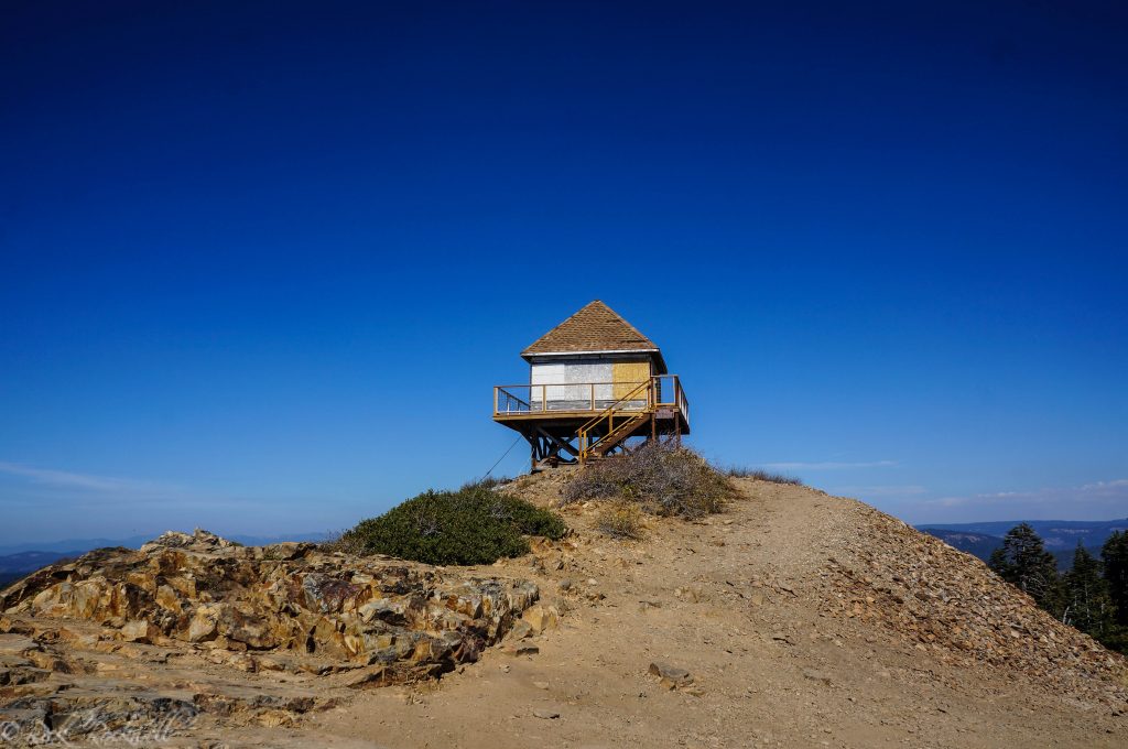
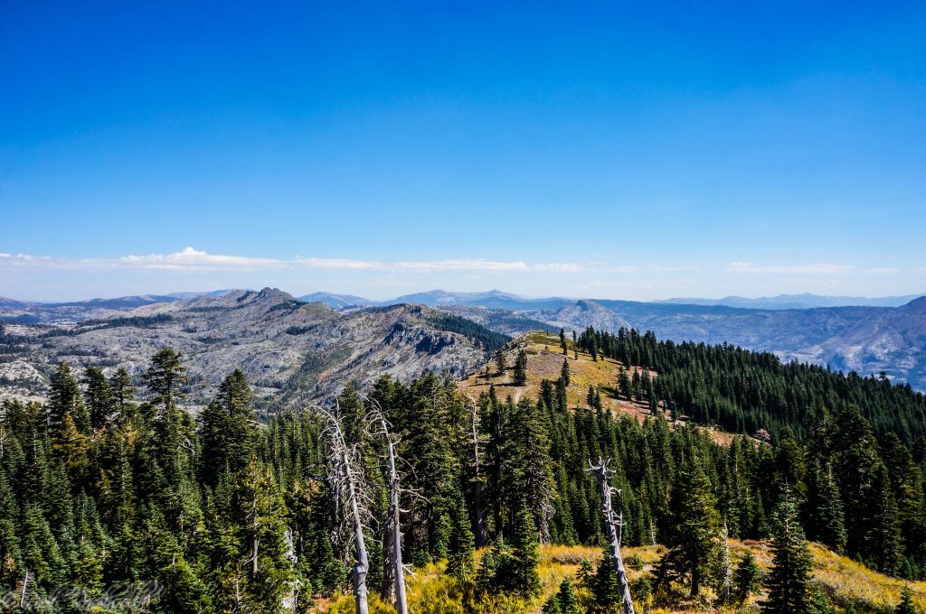
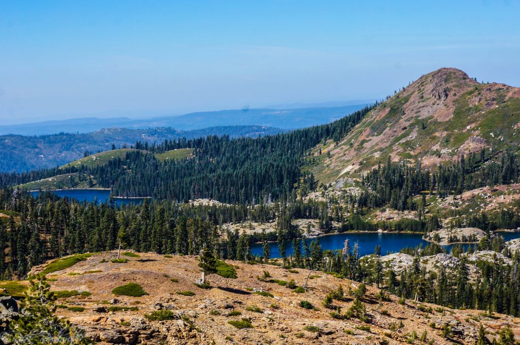
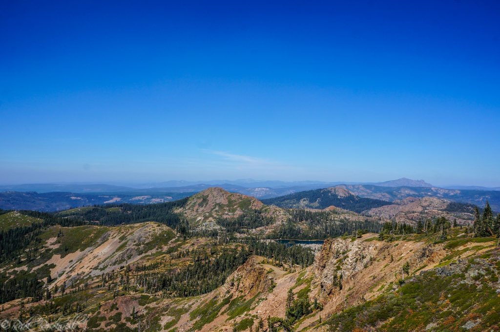
Today, the lookout is one of the more memorable high-country stops in the Grouse Ridge area. Getting there requires patience, a rough forest-road drive, and a short walk from the trailhead area, but the payoff is a historic wooden lookout with wide views over granite, lakes, forested ridges, and Sierra high country.
It is also a place where the journey matters. The final miles on Grouse Ridge Road are slow and bumpy, so this is not the kind of roadside viewpoint you casually tack onto a day without checking conditions first.
Quick Facts About Grouse Ridge Lookout
- Location: Tahoe National Forest, near Grouse Ridge Campground
- Built: 1923
- Access road: Rough dirt road via Bowman Lake Road and Grouse Ridge Road / Forest Road 14
- Vehicle note: High-clearance vehicle strongly recommended
- Short walk: About 1/4 mile from the trailhead/campground area
- Fees: No fee listed for Grouse Ridge Campground
- Facilities: Vault toilet nearby; no potable water; pack out trash
- Best season: Summer into early fall, depending on snow and road conditions
- Interior access: Exterior viewing only unless officially opened or listed for rental
Where Is Grouse Ridge Lookout?
Grouse Ridge Lookout sits in Tahoe National Forest near Grouse Ridge Campground and the Grouse Ridge Trailhead. The lookout is reached from Bowman Lake Road, then Grouse Ridge Road / Forest Road 14, in the high country above the Grouse Lakes area.
This is a remote, rough-road Sierra stop, not an easy paved viewpoint. Check road and weather conditions before heading out.
Directions to Grouse Ridge Lookout
From I-80, take Highway 20 toward Bowman Lake Road / Forest Road 18. Follow Bowman Lake Road to Grouse Ridge Road / Forest Road 14, then continue about 6 miles on the rough dirt road to the Grouse Ridge Campground and trailhead area.
From there, the lookout is about 1/4 mile west, or left, along an old road closed to vehicles.
Road Conditions and Vehicle Advice
Grouse Ridge Road / Forest Road 14 is an unimproved dirt road for the final 6 miles. Expect rocks, ruts, narrow stretches, and slow driving.
A high-clearance vehicle is strongly recommended. Snow, storms, runoff, downed trees, and fire activity can change access, so check Tahoe National Forest conditions before visiting, especially early or late in the season.
Visiting The Grouse Ridge Lookout
Over the years, I have become enamored with these fire lookouts. In addition to their history, the views are incredible.
The Grouse Ridge Lookout has been one of the most challenging lookouts I have reached in terms of driving down unmaintained forest roads. Six miles on this road, weaving through the forest and up to the ridge, definitely makes you question whether or not you really want your vehicle to continue taking punishment.
This is not the kind of road where you want to be rushed, low on gas, or testing a vehicle you are not confident in.
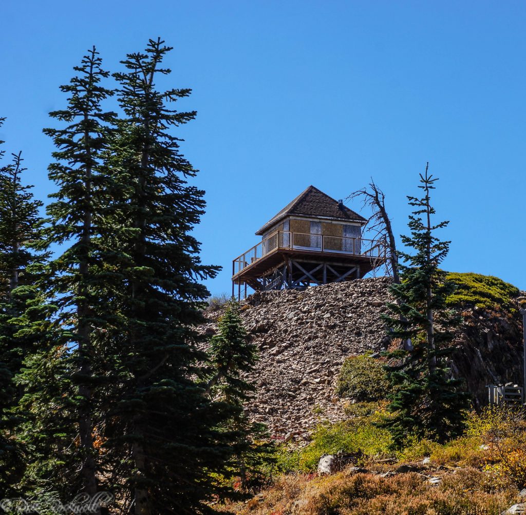
The road dead ends near the trailhead area. From there, head west, or left, about 1/4 mile to the lookout. The walk follows an old forest road that is closed to vehicles. You can feel the climb as you head toward the lookout, and about halfway up, the structure begins to peek through the trees.
Depending on when you visit, the views stretch as far as the eye can see and are absolutely beautiful.
Probably the most amusing part about the lookout is the location of the outhouse. It sits on an outcropping at roughly 7,700 feet in elevation, which makes it one of the more memorable restroom placements you will find in the Sierra.
Can You Go Inside Grouse Ridge Lookout?
No, not under normal public access.
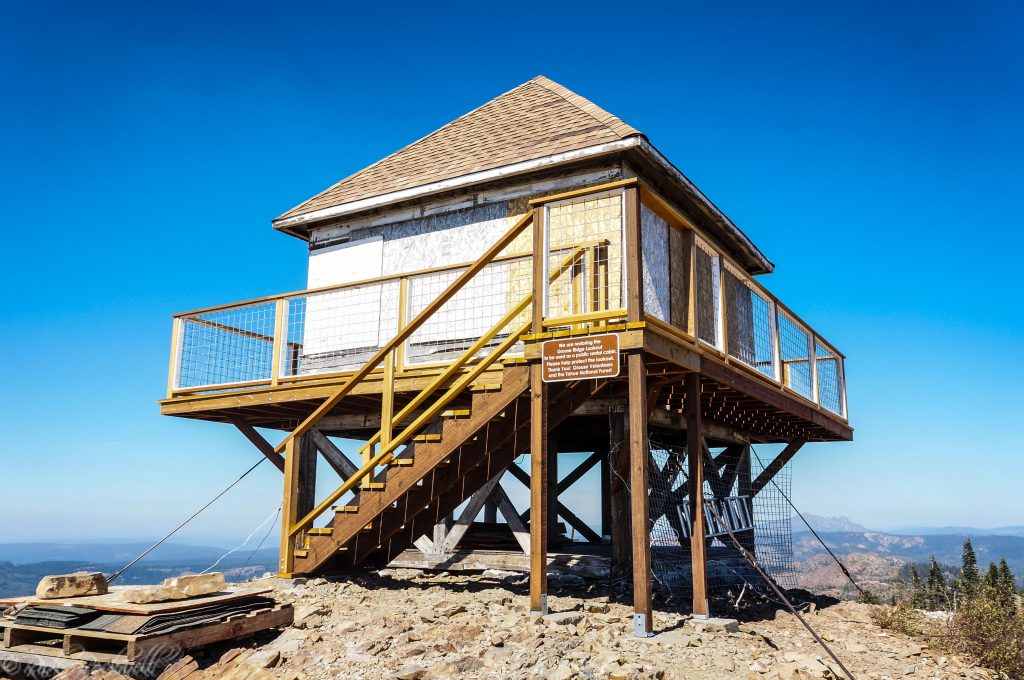
When I visited, I was able to walk around the balcony, but there was no going inside the lookout. That is still the safer way to describe the visit unless the Forest Service or a current restoration partner officially lists the lookout as open or rentable.
Even from the outside, the structure is worth seeing. You can walk around the platform, look at the old cab, and take in the same kind of broad ridge-and-lake views that made the site useful as a fire lookout in the first place.
As always with historic structures, treat the building carefully. Do not force doors, remove materials, carve into wood, add graffiti, or climb on anything that is not clearly meant for public use. Places like this only survive when visitors respect them.

Grouse Ridge Lookout: Parking and Amenities
The nearby Grouse Ridge Campground area is the main facility reference point for visiting the lookout and trailhead area.
The Forest Service lists Grouse Ridge Campground as a no-fee site with nine campsites, tables, fire rings, bear boxes, and a vault toilet. There is no potable water and no trash service.
That means you should bring all the water you need, especially if you are hiking beyond the lookout. You should also pack out everything you bring in.
This is high-country forest travel, not a developed roadside attraction. Do not count on services, cell reception, open facilities, or easy help nearby.
Best Time to Visit Grouse Ridge Lookout
The best time to visit Grouse Ridge Lookout is usually summer into early fall, after the road has opened and before winter weather returns.
The Forest Service lists the general season of use for Grouse Ridge Campground as Memorial Day to mid-October, with normal facility operation from Memorial Day weekend to Labor Day weekend. However, that can change depending on weather. The Forest Service also notes that the campground often opens late because of snow banks on the access road.
Seasonal access problems are not new at Grouse Ridge. A California Lookouts transcription of a June 13, 1943, Nevada State Journal item notes that winter storm damage, snow, and downed timber were delaying access to Grouse Ridge Lookout that June. It is a good reminder that this high-country road has long been shaped by snowpack, weather, and forest conditions.
Do not assume the road is open just because the calendar says late spring or early summer. This area sits high enough that snow and storm damage can linger.
For views, late morning through afternoon can be beautiful, but summer haze, wildfire smoke, thunderstorms, and heat can all change the experience. If skies are clear, the lookout is a fantastic place to take in the surrounding ridges and lakes.

Grouse Ridge Lookout History
During the early 20th century, California and federal forest managers were reshaping how they approached fire prevention, detection, and lookout planning. Coert DuBois was one of the important figures in that larger fire-protection story, especially in California lookout design and planning.
Newspaper records show the Forest Service was looking at Grouse Ridge even before the current lookout was built. A California Lookouts transcription of a September 30, 1915, Truckee Republican item notes that Tahoe National Forest officials were considering Grouse Ridge or Fall Creek Mountain for a new primary lookout to better cover the Upper Yuba headwaters.
By the early 1920s, fire lookouts were becoming a more formal part of California’s mountain fire-detection network. In 1923, the Grouse Ridge fire lookout was built in the Tahoe National Forest, making it one of the older surviving fire lookouts in California.
Historic lookout references suggest that Tahoe National Forest once had numerous lookout sites, though only some still stand today and fewer are still used for their original fire-detection purpose.
That is what makes Grouse Ridge Lookout such a worthwhile stop. It is not just a viewpoint. It is a piece of California fire-history infrastructure still standing in the landscape it was built to watch.
Type of Lookout
The Grouse Ridge Lookout is an early 14-by-14-foot live-in lookout cab, a size and layout that became closely associated with California fire-lookout design. The Grouse Ridge version is especially interesting because of its age and roof style, which makes it feel like an early example of the small wooden lookout cabs that followed across the West.
The lookout cab is 14 by 14 feet and has five windows on each wall, giving rangers 360-degree views while watching for smoke. The one-room lookout sits on a platform roughly 10 feet off the ground.
That 14-by-14-foot size also fits into a larger California fire-lookout story. Forest Service history notes that Coert DuBois’s 1917 live-in cab design established the basic floor plan for many California lookout cabs that followed.
That simple design made sense for the job. A fire lookout needed visibility, airflow, a compact work space, and enough elevation to see smoke columns before a small fire became something larger.
Retirement
In the decades after World War II, and especially as newer technology became more common, many fire lookouts were retired across the state. Airplanes, helicopters, radios, and other detection methods became more effective parts of fire management.
Additionally, fire prevention methods were improving, which helped reduce the need for so many staffed lookout stations.
Grouse Ridge Lookout was part of that larger shift. After serving for decades, it was retired from regular fire-detection use.
Abandonment
After the lookout was retired, it was left abandoned and became a popular spot for hikers and locals. Unfortunately, it also became a popular spot for vandals who damaged the structure, removed pieces, and left graffiti on the historic building.
That is a common pattern with retired fire lookouts. Once they are no longer staffed or maintained regularly, they can deteriorate quickly, especially in places with harsh winter weather and limited road access.
Restoration
After the turn of the 21st century, volunteers began helping care for and preserve the structure. Recognizing its historic value, a more formal approach to repairing the lookout began taking shape. Today, the lookout has undergone restoration work and looks far better than it would have if it had simply been left to the weather and vandals.
Because of its age and historic value, the repairs have been tied to efforts to preserve the lookout as a historic structure.
A 2011 Forest Service Preserve America report noted that rehabilitation work on Grouse Ridge Lookout had been completed in 2010 and approved by the State Historic Preservation Office, with the long-term goal of adding the lookout to the Forest Service recreation-rental program.
A past restoration source also described the long-term goal of making the lookout available for rental during the camping and hiking season, with furnishings such as twin beds, a propane stove, a heater, and possibly propane lighting.
However, visitors should not assume the lookout is currently rentable unless an official Forest Service or Recreation.gov listing confirms it.
Grouse Ridge Trail vs. Grouse Ridge Lookout
One confusing part of this area is the name overlap. Grouse Ridge Lookout, Grouse Ridge Trail, Grouse Ridge Road, Grouse Ridge Campground, and the Grouse Ridge Trailhead area are all related, but they are not the same thing.
The lookout is the historic fire lookout reached by a short walk from the trailhead/campground area.
The Grouse Ridge Trail is a longer Tahoe National Forest trail. The Forest Service lists Grouse Ridge Trail as 8 1/8 miles long, beginning at Eagle Lakes and ending at Sawmill Lake. It is open for hiking and backpacking.
That means you do not have to hike the full Grouse Ridge Trail to visit the lookout. If your main goal is the fire lookout, the walk from the trailhead area is short. If your goal is a bigger hiking day, the trail system can take you deeper toward lakes, granite, forest, and the broader Grouse Lakes area.
Older hiking descriptions and user routes may vary depending on where people start, which side trips they take, and whether they include nearby lakes. For this article, it is safest to separate the short lookout walk from the longer official Grouse Ridge Trail.
Nearby Hikes and Lakes
Grouse Ridge Lookout works well as a short historic stop, but the surrounding area is also known for hiking, backpacking, lakes, and high Sierra scenery. The surrounding Grouse Ridge Non-Motorized Area is part of a larger high-country landscape of granite, alpine lakes, wet meadows, forest, and protected habitat.
Nearby hike or area | What to Know | Best For |
Grouse Ridge Trail | Longer Tahoe National Forest trail that runs into the Grouse Lakes area | Hikers and backpackers who want more than the lookout stop |
Glacier Lake Trail | Popular lake destination connected with the Grouse Ridge trail system | A lake-focused hike from the ridge area |
Grouse Lakes Area | Broader high-country lake basin below the ridge | Backpacking, lake-hopping, and longer Sierra outings |
Carr Lake and Island Lake Area | Nearby lake basin with Carr Lake, Round Lake, Island Lake, and related trails | Building a larger Grouse Ridge hiking cluster |
Bowman Lake Road Stops | Rough-road corridor with access to multiple forest recreation areas | Visitors already exploring the Bowman Lake Road side of Tahoe National Forest |
Grouse Ridge Trail
The official Grouse Ridge Trail is listed by the Forest Service as 8 1/8 miles long, beginning at Eagle Lakes and ending at Sawmill Lake. It is open to hiking and backpacking and gives access to the larger Grouse Lakes area.
The trail is a wonderful Sierra mountain route with access to lakes, granite, forest, and open high-country scenery. Along this trail system are lakes like Glacier Lake and other popular hiking destinations. From the ridge-side access, the route drops away from the high country near the trailhead, which means some hikers will feel the climb more on the way back.
The trailhead area has parking nearby, with Grouse Ridge Campground located close to the access point. The lookout is about 1/4 mile to the left, or west, of the trailhead area and is often visited before or after a hike along the ridge.
Glacier Lake Trail
Glacier Lake is one of the popular lake destinations in the Grouse Ridge area. It is often mentioned with hikes from the Grouse Ridge Trail system and makes sense for visitors who want more than the quick lookout stop.
Grouse Lakes Area
The Forest Service describes hiking and biking trails leading off the ridge toward the Grouse Lakes Area at the base of the ridge. This is one of the big reasons people make the rough drive into this part of Tahoe National Forest.
Carr Lake and Island Lake Area
Carr Lake, Round Lake, Island Lake, and the nearby lake basin make another strong pairing in the broader region. If you are building a Grouse Ridge or Tahoe National Forest hiking trip, add the Carr Lake Trailhead and its destinations to your itinerary.
Bowman Lake Road Stops
Bowman Lake Road itself accesses several recreation areas and forest routes. Conditions vary, so treat this as a rough-road corridor rather than a casual paved scenic drive.
Is Grouse Ridge Lookout Worth Visiting?
Yes, Grouse Ridge Lookout is worth visiting if you enjoy historic fire lookouts, Sierra views, and rougher forest-road destinations.
The lookout gives you history, scenery, and a real sense of place. It is not just another viewpoint. It is a reminder of how fire detection worked before modern technology, when people spent long days in small wooden cabs watching the horizon for smoke.
That said, this is not a stop for everyone. The road is rough, the facilities are limited, there is no potable water, and access depends heavily on season and conditions. If you are not comfortable with unimproved forest roads, Grouse Ridge Lookout may feel like more effort than reward.
But if you like old fire lookouts, high Sierra ridges, quiet forest roads, and places that still feel a little hard-earned, Grouse Ridge Lookout is one of those California backcountry stops that stays with you.
Frequently Asked Questions About Grouse Ridge Lookout
Can you go inside Grouse Ridge Lookout?
No, not under normal public access. Visitors should treat the lookout as exterior-viewing only unless the Forest Service or an official restoration partner says otherwise.
How rough is the road to Grouse Ridge Lookout?
The final stretch on Grouse Ridge Road / Forest Road 14 is an unimproved dirt road. Expect a slow drive, and use a high-clearance vehicle if possible.
How far is the walk to Grouse Ridge Lookout?
From the trailhead and campground area, the lookout is about 1/4 mile away along an old road closed to vehicles.
Is Grouse Ridge Lookout the same as Grouse Ridge Trail?
No. Grouse Ridge Lookout is the historic fire lookout. Grouse Ridge Trail is a longer Tahoe National Forest trail that continues into the surrounding Grouse Lakes area.
When is the best time to visit Grouse Ridge Lookout?
Summer into early fall is usually best. Snow can linger on the access road, and conditions can change, so check Tahoe National Forest updates before visiting.
Sources
Tahoe National Forest — Grouse Ridge Campground
https://www.fs.usda.gov/r05/tahoe/recreation/grouse-ridge-campground
Tahoe National Forest — Grouse Ridge Trail
https://www.fs.usda.gov/r05/tahoe/recreation/trails/grouse-ridge-trail
Grouse Ridge Lookout Restoration Project — original restoration source referenced in earlier article
https://www.grouseridgelookout.org/project.htm
USDA Forest Service / Forest History Society — The History and Architecture of the USDA Forest Service
https://foresthistory.org/wp-content/uploads/2017/01/HistoryArchitectureUSDA-Part1.pdf
Advisory Council on Historic Preservation — 2011 Forest Service Preserve America Section 3 Report
https://www.achp.gov/sites/default/files/2018-09/2011%20FS%20Section%203.pdf
Bear Yuba Land Trust — Grouse Ridge Conservation Easement https://www.bylt.org/bylt-secures-protection-of-857-acres-in-grouse-ridge/
California Lookouts — Grouse Ridge Lookout
https://californialookouts.weebly.com/grouse-ridge.html
Note: California Lookouts was used for transcribed newspaper leads from the Truckee Republican and Nevada State Journal. Original scans should be pulled before direct quotation.
CalExplornia — Grouse Ridge Lookout field notes and photos