

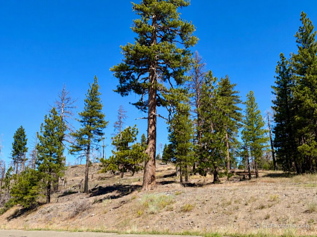
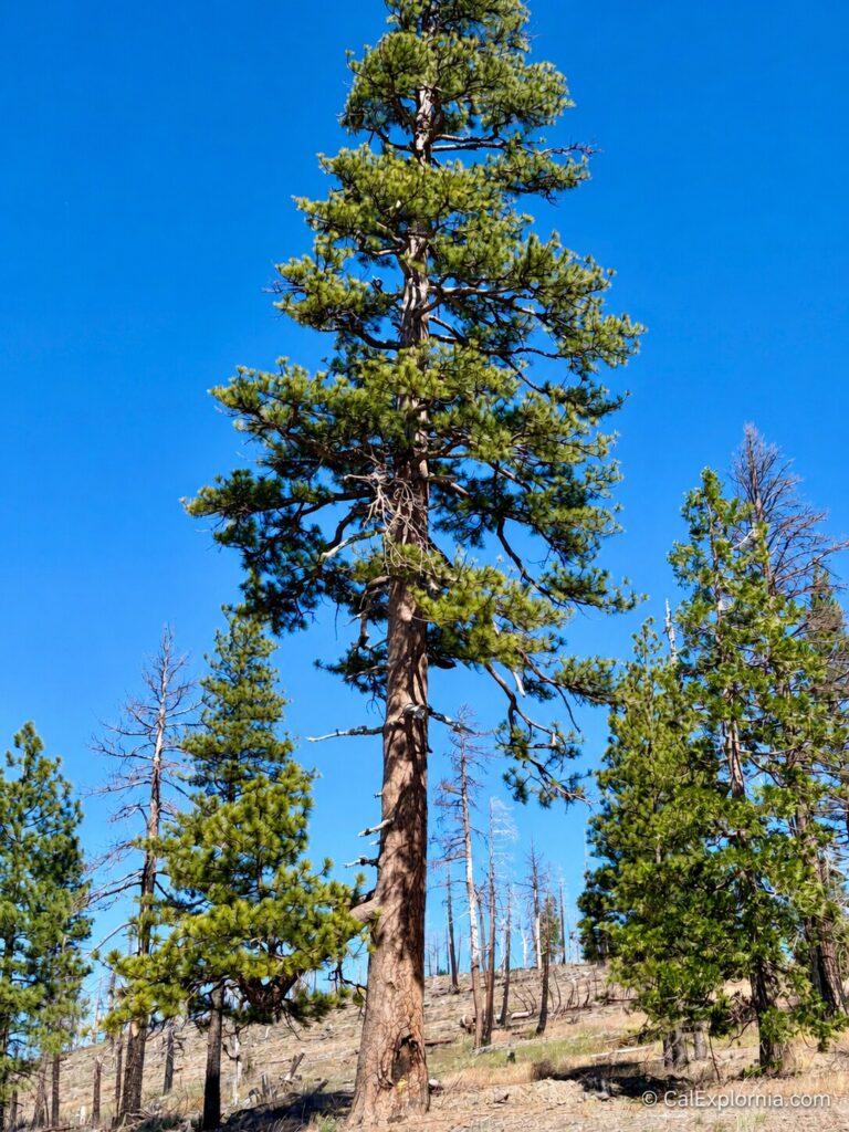
The Old 49er Tree is one of those Sierra history stops that is easy to miss unless you know the story first. It stands near Darlington Flat along Mormon Emigrant Trail, between the Highway 50 side of Eldorado National Forest and the Highway 88 / Carson Pass corridor.
Officially documented as the Old 49 Road Tree, this historic roadside tree once carried a blaze pointing travelers toward the “old 49 road.” The lettering and directional arrow turned the tree into a practical guidepost tied to the Gold Rush-era Carson Pass route.
The original inscription is gone now, destroyed in a 1984 fire. What remains is a quieter landmark with a much bigger story: an emigrant road cut across the Sierra in 1848, Gold Rush traffic moving west, trading posts and lodging houses serving the wagon route, a lower road bypassing rougher terrain, preservation efforts in the 1970s, and a fire that erased the tree’s most famous feature.
Quick Facts About the Old 49er Tree
- Historic name: Old 49 Road Tree, also called the Old 49er Tree, 49er Tree, and 49er Pine
- Location: Near Darlington Flat along Mormon Emigrant Trail in Eldorado National Forest, El Dorado County
- GPS coordinates: 38.704367, -120.389133
- Historic context: Part of the Carson Pass emigrant route; Mormon Emigrant Trail was formerly known as Iron Mountain Road
- Significance: Historic tree marker that pointed north toward an older Gold Rush-era wagon-road alignment
- Tree details: Ponderosa or Jeffrey pine at about 5,800 feet elevation
- Key dates: Protected with a fence in 1972; historic inscription destroyed by fire in 1984
- Best for: Gold Rush history fans and old-road explorers
- Best time to visit: Late spring through fall, depending on snow and road status
Where Is the Old 49er Tree?
The Old 49er Tree stands near Darlington Flat on the north side of Mormon Emigrant Trail in Eldorado National Forest. The Historic American Landscapes Survey places it roughly three-quarters of a mile east of North-South Road, along the high-country connection between the Highway 50 side of the forest and the Highway 88 / Carson Pass area. The official Library of Congress record gives the coordinates as 38.704367, -120.389133.
Finding and Visiting the Old 49er Tree
The Old 49er Tree is near Darlington Flat west of the Sierra crest, along Mormon Emigrant Trail. This paved forest road runs seasonally between the Sly Park / Highway 50 side of Eldorado National Forest and the Highway 88 corridor near Silver Lake, Caples Lake, and Carson Pass.
If you are driving toward Highway 88 from the Sly Park area, the tree will be on your left side. The easiest way to find it is to plug the GPS coordinates 38.704367, -120.389133 into your navigation app before heading into the forest.
As of July 2026, Eldorado National Forest listed Mormon Emigrant Trail / Iron Mountain Road as open, but the road remains subject to seasonal and winter restrictions. The Forest Service notes that it closes to passenger vehicles in winter, and conditions can change after storms, during spring melt, or when forest-road restrictions are in effect.
When visiting, pull over only where it is safe and legal. Do not block the road, walk into traffic, or step onto unstable shoulders.
During snow-free months, the Old 49er Tree is generally a quick roadside stop rather than a hike. Most visitors may only spend 5 to 15 minutes here.
However, if you are like me, you might stay for 30 minutes or more as you take in the history and excitement of standing beside a tree that once served as a road sign during California’s Gold Rush era.
The real challenge is knowing what you are looking at. Because the original blaze was destroyed, the site is much easier to appreciate when you understand why the tree mattered and what happened to it.

Why Is It Called the Old 49er Tree?
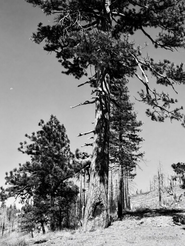
The name comes from the historic blaze that once marked the trunk.
According to the Historic American Landscapes Survey, the tree carried the words “old 49 road” with an arrow pointing north. The mark directed travelers toward an older route alignment after part of the original road had been bypassed.
By the mid-1850s, a lower road had been created south of the original 1848 alignment near Darlington Flat. HALS dates that change to around 1853, although the exact reason for the rerouting is not documented.
The terrain offers a clue.
Emigrants crossing Old Iron Mountain did not have kind words for the road. On September 1, 1850, William B. Ogle wrote that his party had traveled six miles over what he called the “damedst hills,” describing the stretch as roughly four miles up and two miles down.
Thomas Christy was not any more impressed. On August 4, 1850, he described the road as “very rough and uneaven” and wrote of a mountain climb about a mile and a half long that was “verry steep in some places.”
The newer road therefore appears to have been less a shortcut to a different destination than a wagon-road improvement: a lower alternative that avoided at least part of the rougher Old Iron Mountain ridge route.
The newer road therefore appears to have been less a shortcut to a different destination than a wagon-road improvement: a lower alternative that avoided at least part of the rougher Old Iron Mountain ridge route.
At the fork, someone carved directions into a tree. The arrow pointed north toward the original road, which was already becoming the “old 49 road.”
The “49” in the name points to Gold Rush migration and the overland traffic that crossed the Sierra by way of Carson Pass. Some later accounts connect the carving to an unknown emigrant, but the identity of whoever made it remains uncertain. HALS says the inscription may date to the mid-1850s.
The Gold Rush History Behind the Old 49er Tree
The Old 49er Tree belongs to the larger story of the Carson Pass emigrant route, one of the important overland approaches into California during the Gold Rush era.
In 1848, a group of Mormon travelers (44 men and one woman) set out to find a wagon route across the Sierra. Thirty-nine of the men were veterans of the Mormon Battalion, while five had worked at Sutter’s Mill during the period surrounding the discovery of gold.
Three other veterans had gone ahead to scout the route, but they never returned. The main party later found their bodies at the place that became known as Tragedy Spring.
The route builders were not following a road. In many places, they were making one as they went.
Addison Pratt remembered that after the party stopped near Sly Park, scouts went ahead to see whether wagons could cross the country in front of them. They returned with a grim assessment: “a road could barely be made with much labour.”
The company pushed on anyway. Men went ahead to scout and clear a way for the wagons and livestock.
Farther east, Pratt recorded that the group spent four days making one canyon section passable before the wagons could continue. Even the summer snow caused trouble. In late July, he wrote that the party “capsized two or three waggons in crossing snow banks.”
For roughly 46 miles, the group followed the watershed divide while climbing from around 3,000 feet toward 9,000 feet.
Even in July, they encountered deep snowbanks, frozen lakes, broken wagons, steep descents, and nights cold enough for ice to form.
The party had to find, clear, and sometimes build a route capable of carrying wagons and livestock across the Sierra.

The Carson Road Became More Than a Trail Through the Mountains
The Gold Rush road did not remain an empty track across the Sierra. As traffic increased, businesses appeared to serve the people, animals, and wagons moving through the mountains.
An 1883 history of El Dorado County preserved a directory of stations said to have operated along the old Carson Road in 1854, with distances measured westward from Old Mormon Station at present-day Genoa, Nevada.
At Red Lake Valley, about 40 miles from Old Mormon Station, Walgamot and French operated the Red Lake House and advertised “accommodations for all.”
Farther west, the directory listed Shipley and Dupont at Tragedy Springs, 59 miles from Old Mormon Station and only one mile from Silver Lake.
The surrounding entries show how developed parts of the road had become. Morris & Co. operated a trading post and served meals two miles away, while another two miles down the road stood Hoboken, a hotel and trading post.
By the mid-1850s, travelers along parts of the Carson Road could move between a chain of ranches, meal stops, trading posts, hotels, and other businesses built around the steady flow of wagons, livestock, and people crossing the Sierra.
Thousands of Animals and Hundreds of Wagons
The scale of that traffic becomes clearer in the surviving numbers.
The same 1976 historical account cited an immigration register for the summer of 1854 that counted:
- 808 wagons
- 30,015 cattle
- 1,903 horses and mules
- 8,550 sheep
Those numbers give a very different impression from the quiet forest road visitors see today. Hundreds of wagons and tens of thousands of animals moved through the broader corridor during a single summer season.
Stump Spring and the Roadside World Around the Tree
About a mile west of the Old 49er Tree, Stump Spring was already serving travelers before the Carson Road became a busy Gold Rush route. The 1848 Mormon party camped at the spring while opening the wagon road across the Sierra.
Six years later, an El Dorado County station directory listed Peter Peters as operating a trading post 68 miles west of Old Mormon Station. A later historical account identified Stump Spring as the site of Peters’ business.
When Betty Shannon visited the area for a 1976 Desert Magazine article, she found the spring about 100 feet south of the road, with a portion of the old emigrant trail still passing through the forest nearby.
She also described water from the spring flowing through a hollowed-out cedar log that had once served as a livestock watering trough.
The trading post, spring, and old cedar trough fit into the growing network of services that developed along the Carson Road as emigrant traffic increased.
For travelers and their animals, a reliable source of water could make a place worth stopping at, and businesses such as Peters’ trading post grew around those needs.
How the Old 49er Tree Was Protected in 1972
By the early 1970s, the Old 49er Tree had survived more than a century of Sierra weather, road changes, logging, and passing traffic. Its old blaze was still visible, but local preservationists were worried that vandalism could erase what time had not.
In September 1972, representatives from American Forest Products and the Sierra Chapter of the Sons of Utah Pioneers organized a work party to protect the tree.
They traveled to the site and built a wooden fence around the trunk, creating a physical barrier between the historic carving and anyone tempted to damage it.
The effort drew newspaper attention. The Placerville Mountain Democrat announced that a “work party” would mark the historical site, while the Sacramento Bee later referred to the tree itself as a “49er Road Sign.”
That phrase gets to the heart of why people cared. It was a surviving piece of Gold Rush history—a directional marker left from a time when travelers crossing the Sierra depended on signs, blazes, landmarks, and the knowledge of those who had gone ahead of them.
That makes the tree’s later story even more frustrating. The 1972 fence was meant to preserve the old blaze, but just 12 years later, the structure itself would become part of the fire that destroyed it.
What is equally disappointing today is how little visible protection or interpretation seems to remain at the site. The tree once inspired an organized preservation effort and newspaper coverage; more than 50 years later, that same sense of urgency appears to have faded.
From Iron Mountain Road to Mormon Emigrant Trail
The road name visitors know today also comes out of the 1970s preservation push.
Mormon Emigrant Trail was formerly known as Iron Mountain Road. In 1974, after lobbying by the Sierra Chapter of the Sons of Utah Pioneers, the road’s public identity shifted toward its emigrant-route history.
HALS cites the Sacramento Bee article “Iron Mountain Road Yields to New Name of Mormon-Emigrant Trail,” published May 22, 1974, and the Placerville Mountain Democrat article “Canon shot to mark dedication of the Mormon-Emigrant Trail,” published August 1, 1974.
However, two years after the Mormon Emigrant Trail name was adopted, Desert Magazine reported that travelers approaching from Highway 88 could still find an old “Iron Mountain Road” sign pointing the way.
A Final Look at the Old Carving Before the Fire
The preservation work around the Old 49er Tree and the campaign to restore the Mormon Emigrant Trail name brought renewed attention to the old road during the 1970s. That interest also sent writers and history enthusiasts back into the mountains to see what remained.
In 1976, Betty Shannon visited the route for her Desert Magazine article, “The New Old Mormon-Emigrant Trail.” Her account provides one of the clearest descriptions of the Old 49er Tree before the fire.
The blaze and directional arrow were still visible, but the tree was already beginning to reclaim the carving.
Shannon described heavy bark growing over parts of the crude lettering, including a portion of the word “road,” while enough of the old mark remained for visitors to understand what they were looking at.
Shannon repeated the story that an unknown emigrant had carved the marker into the tree. The identity of the carver remains unconfirmed, but her account preserves something just as valuable: a picture of the tree at a moment when its old road sign was fading but still readable.
Eight years later, the carving would be gone.
The Fire That Nearly Destroyed the Old 49er Tree
The protective fence built around the Old 49er Tree in 1972, was supposed to shield the landmark from vandalism. Unfortunately, it ended up becoming the fuel for a fire that almost erased history.
In 1984, an arsonist reportedly stacked the wooden fence against the tree and set it on fire.
According to the Historic American Landscapes Survey, the tree survived, but the historic “old 49 road” inscription did not.
That single event changed how visitors experience the site today. The most famous part of the tree (the carved road sign) is gone. What remains is the tree, the documented fire damage, and the historical record of what visitors once saw on its trunk.
The fire was covered by the Sacramento Bee in “Historic Marker Tree Burned,” published March 6, 1984, and by the Placerville Mountain Democrat in “Marker Burned,” published March 9, 1984.
The bitter irony is hard to avoid: a fence built to protect the tree became part of the fire that destroyed its most important historical feature.
What Can You See at the Old 49er Tree Today?
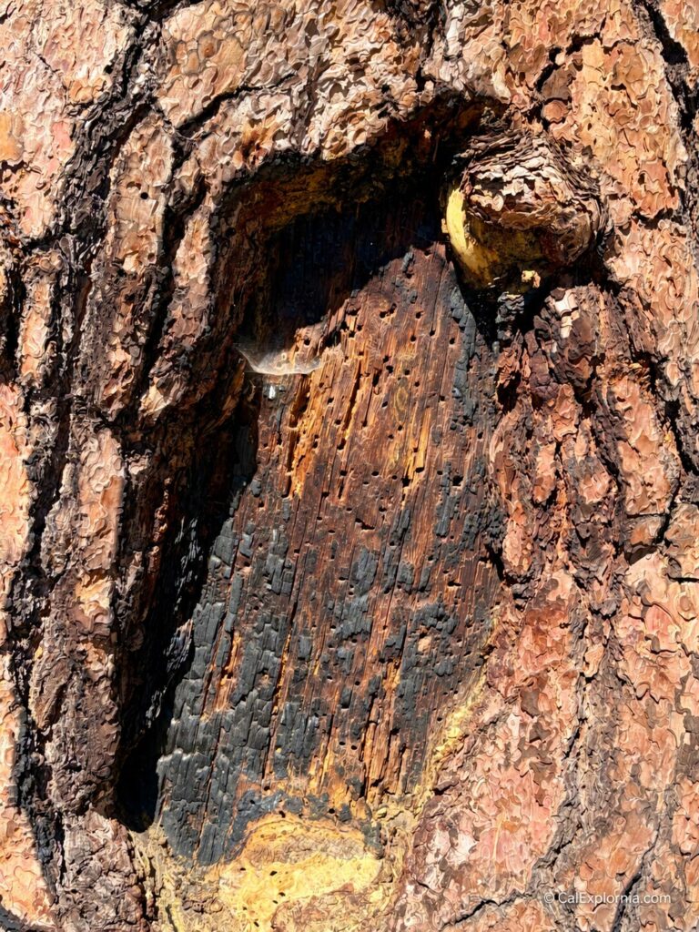
The original “old 49 road” carving and directional arrow are gone, so the tree does not immediately reveal the story that made it historically important.
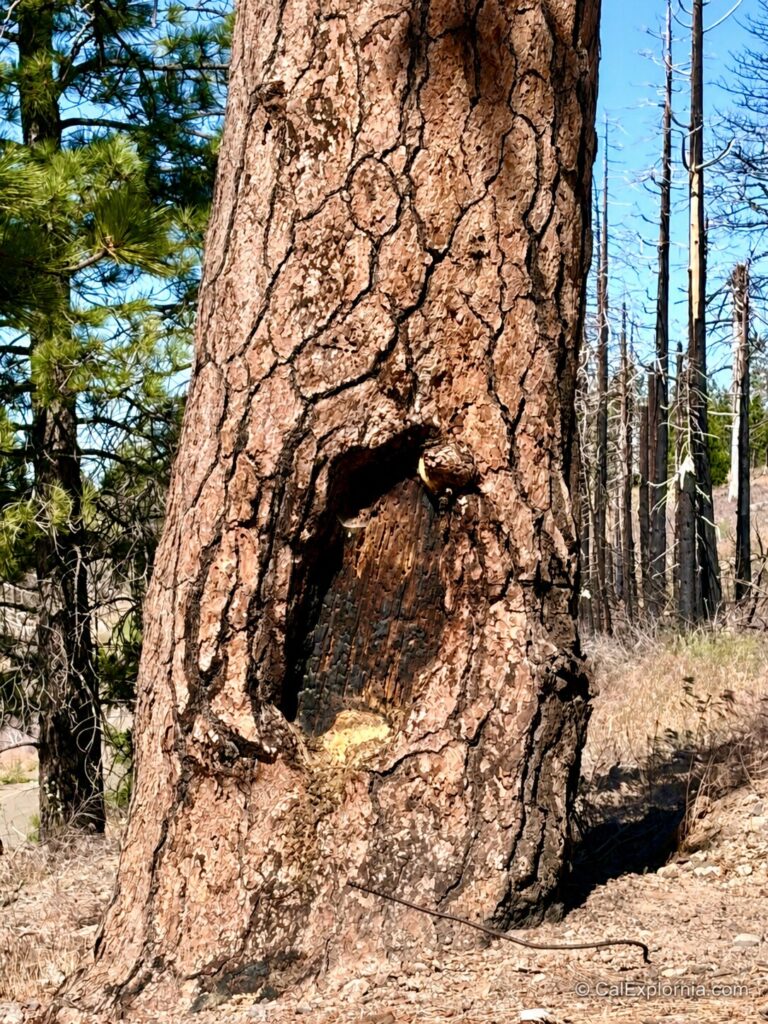
The 1984 fire destroyed the inscription, but evidence of the tree’s long and sometimes destructive history remained when the site was documented for the Historic American Landscapes Survey.
The survey recorded saw-cut marks on the north and west sides of the trunk and a charred scar on the lower east side where the old blaze once existed.
That means visiting the Old 49er Tree today is very different from seeing it in Betty Shannon’s 1976 account, when the old lettering and arrow could still be read.
Today, the experience is mostly about standing beside the surviving tree, looking at what remains, and understanding the role it once played along the old route.
I recommend taking some time to look beyond the tree as well. From both sides of the highway, you can enjoy wonderful views of the surrounding Sierra landscape.
Between the history and the scenery, I found myself spending far more time here than I expected.
Other Historic Stops Along Mormon Emigrant Trail
The Old 49er Tree works best as part of a larger Mormon Emigrant Trail and Carson Pass history route.
Tragedy Spring
Tragedy Spring is tied to the three men who went ahead of the 1848 route-making party and were later found dead in the area. It is one of the most important historic stops along Mormon Emigrant Trail.
Maiden’s Grave
Maiden’s Grave is another Highway 88 / Carson Pass roadside history stop. Its story also carries a long-running urban legend over whether the public monument marks the grave described in the traditional account.
Devil’s Ladder
Devil’s Ladder connects to the difficult terrain faced by emigrants on the Carson Route. Its steep climb toward Carson Pass helps explain why road building, route finding, and even a simple directional marker could matter so much.
Carson Pass
Carson Pass provides the larger geographic context for the Old 49er Tree. The pass was one of the important Sierra crossings used during the Gold Rush era and remains a major recreation corridor today.
Is the Old 49er Tree Worth Visiting?
Yes, the Old 49er Tree is worth visiting, especially if you enjoy Gold Rush history and unusual roadside attractions with deep stories behind them.
I first set out to find this tree before COVID, but I couldn’t locate it. It turns out that my son and I had unknowingly driven past it several times while traveling up and down Mormon Emigrant Trail.
Even after that failed attempt, I never gave up on finding it. This was a place I wanted to see and a story I wanted to tell.
A few years later, I found the HALS report during another round of research and discovered that it included the tree’s GPS coordinates. After years of wondering exactly where it stood, finding those coordinates felt like Christmas morning.
This summer, on the way to spend a few days in Lake Tahoe, my beautiful girlfriend and I made the Old 49er Tree part of a larger history and road-trip day. We paired it with stops at Maiden’s Grave, Tragedy Spring, a few lakes, and Markleeville before continuing on to Tahoe.
When I finally spotted the tree, I was so excited that I nearly jumped out of the car before putting it in park.
Sure, it’s disappointing that the original blaze is gone, but that does not erase the tree’s importance.
Standing beside it and looking across the surrounding Sierra landscape, I could finally appreciate why this tree had stayed on my mind for so many years.
FAQ About the Old 49er Tree
Where is the Old 49er Tree?
The Old 49er Tree is near Darlington Flat on the north side of Mormon Emigrant Trail in Eldorado National Forest, about three-quarters of a mile east of North-South Road.
Why is it called the Old 49er Tree?
The name comes from the historic “old 49 road” blaze that once marked the tree and pointed north toward the original wagon-road alignment.
Can you still see the original carving?
No. The original carving was destroyed in a 1984 fire, although the tree survived.
Is there a hike to reach the Old 49er Tree?
The Old 49er Tree is generally treated as a roadside history stop rather than a hike. Parking and pullout conditions can change, so stop only where conditions are safe and legal.
Is Mormon Emigrant Trail open year-round?
No. Mormon Emigrant Trail is a high-elevation road that closes to passenger vehicles in winter. Check Eldorado National Forest road status before planning a trip.
Sources
Library of Congress / Historic American Landscapes Survey — Old 49 Road Tree, HALS CA-149
https://www.loc.gov/pictures/item/ca4442/
Historic American Landscapes Survey Written Historical and Descriptive Data — Old 49 Road Tree, HALS CA-149
https://tile.loc.gov/storage-services/master/pnp/habshaer/ca/ca4400/ca4442/data/ca4442data.pdf
Eldorado National Forest Road and Trail Status
https://www.fs.usda.gov/r05/eldorado/conditions/road-and-trail-status
1850 Overland Accounts
William B. Ogle, Diary of Trip to California, 1850
William Henry Smith Memorial Library, Indiana Historical Society. Mattes 913.
Thomas Christy, Thomas Christy’s Road Across the Plains
A Guide to the Route from Mormon Crossing, Now Omaha, Nebraska, to the City of Sacramento, California, Via the North Side of the Platte River to Fort Laramie; Thence to Casper, Wyoming; Following the Sweetwater River to South Pass. Thereafter by Sublett’s and Hudspeth’s Cut-offs, to the Humboldt and Carson Rivers, and over the Sierra Nevada Mountains to the Famous Gold Diggings in California Compiled From His Personal Observations During the Spring and Summer of 1850. Edited by Robert H. Becker. Denver: Old West Publishing Co., 1969.
National Park Service bibliography confirming the Ogle manuscript and Christy publication details
https://www.nps.gov/oreg/learn/historyculture/upload/NPS-HRS-Biblio-Update2015-web.pdf
Supporting / Near-Official Sources
Eldorado National Forest Interpretive Association Highway 50 / Current Forest Notes https://enfia.org/discover/highway-50/
Archive / Newspaper Leads Cited by HALS CA-149
Sacramento Bee, “49er Road Sign,” Sept. 25, 1972, p. 6.
Placerville Mountain Democrat, “Work party will mark historical site Saturday,” Sept. 21, 1972, p. A-6.
Sacramento Bee, “Iron Mountain Road Yields to New Name of Mormon-Emigrant Trail,” May 22, 1974, p. 11.
Placerville Mountain Democrat, “Canon shot to mark dedication of the Mormon-Emigrant Trail,” Aug. 1, 1974, p. C-1.
Sacramento Bee, “Historic Marker Tree Burned,” Mar. 6, 1984, p. 8.
Placerville Mountain Democrat, “Marker Burned,” Mar. 9, 1984, p. A-2.
Newspaper citations are listed from HALS CA-149; original scans should be pulled before direct quotation.
Supporting Historical Color
Betty Shannon, “The New Old Mormon-Emigrant Trail,” Desert Magazine, Dec. 1976
Used for pre-fire visual details, historical traffic figures, station-directory context, Stump Spring details, and 1970s road-sign color. HALS remains the stronger source for the exact tree inscription wording and documented fire history.
https://dhshistoricalsociety.org/wp-content/uploads/2025/03/197612-DesertMagazine-1976-December.pdf
Mountain Democrat / CDNC archive lead for 1983–1987 holdings
https://cdnc.ucr.edu/?a=cl&cl=CL1&sp=MDP
Mountain Democrat, May 23, 1857, Johnson Cutoff / Placerville route context lead
https://cdnc.ucr.edu/?a=d&d=MDP18570523.2.20.1
Sacramento Daily Union, “From Sacramento to Carson Valley,” Nov. 15, 1859
https://cdnc.ucr.edu/?a=d&d=SDU18591115.2.2