Auburn State Recreation Area: A Guide To Trails, Waterfalls, Swimming, Camping, And Gold Country History
Table of Contents
Auburn State Recreation Area is one of the most dynamic outdoor destinations in Northern California. The ASRA is a sprawling canyon landscape where hiking trails, river access, swimming spots, campgrounds, waterfalls, whitewater, Gold Country and Native American history all come together in one place.
Stretching 30,600 acres and roughly 40 miles along the North and Middle Forks of the American River near Auburn, this is not the kind of park you experience in a single overlook, one short trail, or in one visit. It is a full recreation region, with enough variety to build an easy day trip, a rugged hiking weekend, or a multi-trip adventure around its trails, water features, and historic landmarks.
What makes Auburn SRA even more exciting, is its mix of adventure and history. One part of the park is defined by steep canyon hikes, lake access, and river bars, while another is shaped by old stagecoach routes, quarry corridors, historic bridges, and the unfinished legacy of Auburn Dam.
That range gives the ASRA a depth many state or regional parks do not have. Auburn State Recreation Area is not just a place to “go outside”. It is one of the best outdoor places in the Sierra foothills to experience how California’s natural beauty, recreation culture, and layered history all meet in one thrilling landscape.
Auburn State Recreation Area Quick Facts
- Location: Near Auburn in Placer and El Dorado counties
- Size: About 30,600 acres
- River Corridor: About 40 miles along the North and Middle Forks of the American River
- Trail System: More than 100 miles of hiking and horse trails
- Signature Areas: Confluence, Lake Clementine, Quarry Trail, Foresthill Divide, Olmstead Loop, Mineral Bar, Ruck-A-Chucky
- Major Activities: Hiking, trail running, swimming, boating, rafting, camping, mountain biking, fishing, horseback riding
- Famous Route: Western States Trail
- Day-use Fee: Standard vehicle day-use fee listed at $10
- Best For: Day hikes, trail weekends, river days, Gold Country history, endurance events
Where Auburn State Recreation Area Is Located
Auburn State Recreation Area is in the Sierra foothills near Auburn in Placer and El Dorado counties, stretching along the North and Middle Forks of the American River. From Sacramento, the easiest route is to take I-80 east to Auburn, then follow Highway 49, Auburn-Foresthill Road, or other local access roads depending on whether you are heading to the Confluence, Lake Clementine, or another part of the park.
Auburn State Recreation Area: Know Before You Go
| What to know | Why it matters |
|---|---|
| Day-use fees | Main fee areas charge for parking, so plan for a day-use fee instead of assuming every access point is free. |
| Reservations | Some areas, especially Lake Clementine during peak periods, may require advance reservations or have limited access. |
| Heat | Auburn SRA can get extremely hot in summer, and exposed canyon trails often feel harder than their mileage suggests. |
| Water | Bring more water than you think you need, especially for hikes, river days, or summer visits. |
| No potable water at campgrounds | Primitive campgrounds like Mineral Bar, Ruck-A-Chucky, and Lake b do not provide drinking water. |
| Closures | Seasonal road, trail, and campground closures can affect access, especially in winter or after storms. |
| Dogs | Dog rules vary by area, and some spots, including Lake Clementine, do not allow dogs. |
| Boating restrictions | Lake Clementine has seasonal boating rules, launch restrictions, and vessel inspection requirements. |
| Limited services | Some of the more remote areas have few services, so visitors should be prepared for a rougher, more self-sufficient outing. |
Due to its size and versatility, it’s best to approach the Auburn State Recreation Area as a region with different outdoor zones than just one park.
From there, the next step is to plan what kind of recreation adventure or leisure activity that you want to enjoy: a short scenic hike, a swim-and-relax river day, a longer trail run, a history-focused outing, or a more remote campground experience.
For example, if you want a short-scenic hike, then the Bridgeview Trail (0.8 miles) is an ideal choice. Perhaps, a swim in Clarks Hole would be perfect for your day off in the Summer. Other options could include boating on Lake Clementine, hiking or biking through history on the old Stagecoach Trail, whitewater rafting down the American River, or camping at Mineral Bar.
Once you decide your adventure or activity, then you can choose which part of the ASRA that fits your goal. Lastly, you will want to select where to park and make sure you have the appropriate day-use fee.
The Auburn State Recreation Area has a handful of trailheads with parking in addition to various spots along the highways that people park at.
The Main Areas Of Auburn State Recreation Area
As mentioned above, the Auburn State Recreation Area has a variety of different outdoor zones filled with activities specific to that area of the park. Those major outdoor zones include the following:
| Visitor Type | Best Area | Why It Fits |
|---|---|---|
| First-timers | The Confluence | Best overall introduction to Auburn SRA with river access, canyon scenery, and several major trail connections. |
| Families | Upper Lake Clementine | Easier warm-weather destination with lake access, day-use facilities, and a more relaxed outing style than steeper canyon trails. |
| Swimmers | Clarks Hole or Upper Lake Clementine | Clarks Hole is one of the park’s classic natural swimming spots, while Upper Lake Clementine is easier for a more traditional swim day. |
| Hikers | Confluence / Stagecoach / Foresthill Divide | These areas give hikers some of the best access to classic canyon trails, historic routes, and longer loop options. |
| Bikers | Quarry Trail / Foresthill Divide | Both areas work well for riders, with Quarry Trail offering easier mileage and Foresthill Divide giving a bigger canyon ride. |
| Equestrians | Cool Trailhead / Western States Trail corridor | The Cool side and Pleasant Avenue access are among the park’s best horse-friendly staging areas. |
| Campers | Mineral Bar or Ruck-A-Chucky | These campgrounds give visitors a more immersive canyon experience than a quick day-use stop. |
| History Fans | No Hands Bridge / Quarry Trail / Stagecoach Trail | These areas combine scenery with railroad, quarry, stagecoach, and Gold Country history. |
The Confluence
The Confluence is the most important orientation point in the park. It is the main trailhead area for hiking and mountain biking, with access toward Lake Clementine, Mammoth Bar, Stagecoach Trail, and the North Fork corridor. It is also one of the busiest areas in summer, which says a lot about how central it is to the Auburn SRA experience.
For a first visit, this is often where Auburn SRA makes its strongest impression. The canyon walls feel immediate, the river is close, and the number of trail options makes it a suitable starting point for most visitors.
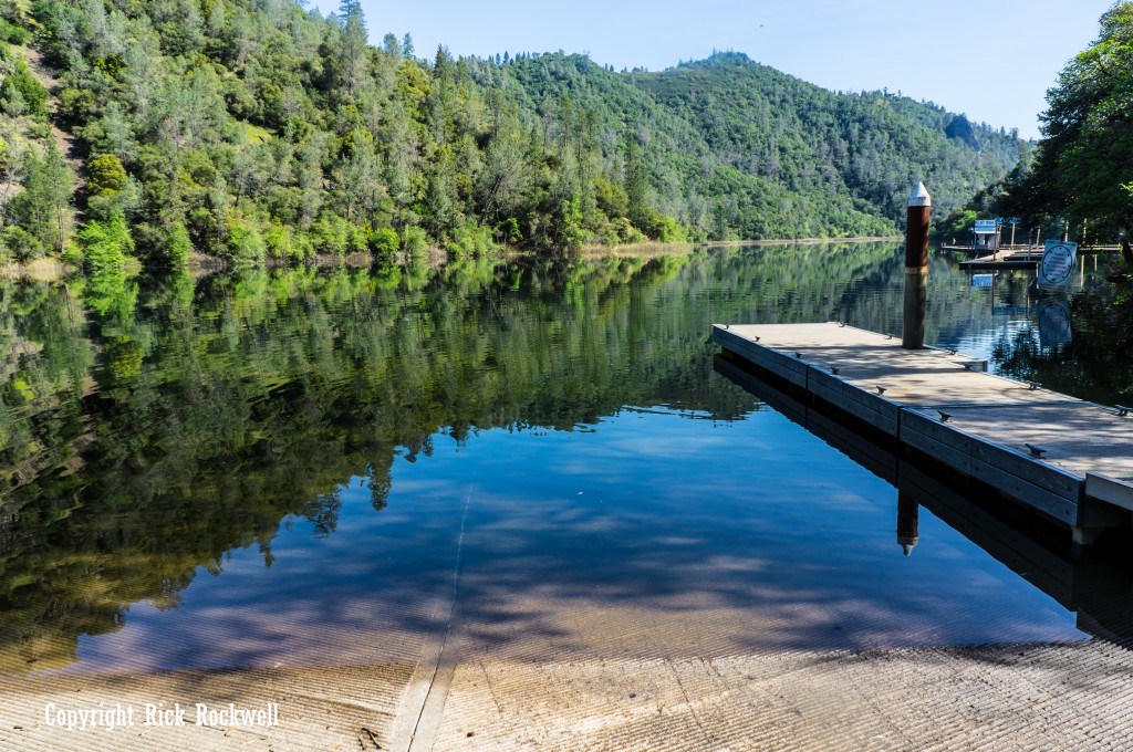
Lake Clementine
Lake Clementine is one of the best-known destinations within the park, and it gives Auburn SRA a broader summer identity than a rugged trail system through the river canyons. Lower Lake Clementine is accessible only by boat, Upper Lake Clementine is day-use only, dogs are not allowed within the boundaries of either upper or lower lake areas, vehicle access and seasonal openings can vary. Parking fees and reservation requirements for some weekend day-use access can also apply.
That planning detail matters. Lake Clementine is not just a scenic name dropped into the park overview. It is one of the main places where boating, shoreline use, and warm-weather recreation shape the Auburn SRA experience.
Quarry Trail Corridor
Quarry Trail is one of the most useful trails because it combines easier mileage with some of the park’s clearest historic timeline. This wide, level 5.6-mile trail follows the route of an old Gold Rush-era flume, and later part of it was used by the Mountain Quarries railroad to haul limestone from the adjacent quarry.
The Quarry Trail is an easy outing and one of the handful of places where history and adventure overlap to create a deeper experience.
Cool And The Olmstead Loop Side
The Cool side gives the park a different feel. Olmstead Loop is an 8.8-mile easy-to-moderate route through rolling oak woodlands, with descents, climbs, and water crossings, running near Highway 49 on one side and the canyon on the other.
This region shows that the ASRA is a larger recreation area with more variety than most realize. The broader foothill terrain works well for hikers, equestrians, and those wanting a longer-trail outing.
Foresthill Divide
Foresthill Divide is one of the stronger long-trail zones in the park. The Foresthill Divide Loop is a 10.6-mile route with views of Lake Clementine and both forks of the American River, and it is often described as a quintessential American River Canyon experience for hikers, cyclists, trail runners, and equestrians.
Things To Do In Auburn State Recreation Area
Auburn State Recreation Area is a vast and versatile outdoor playground. It reminds me of the Crystal Basin, in regards to the volume of recreational activities you can participate in. Yet, it’s a vastly different landscape, which gives Northern Californians a wonderful contrast to the mountainous region.
With that said, the following is a list of popular things to do in the Auburn State Recreation Area:
Camping
Camping gives visitors, a chance to experience the quieter, rougher, and more immersive side of Auburn State Recreation Area. Instead of polished resort-style campgrounds, Auburn SRA offers a more primitive canyon experience through places like Mineral Bar, Ruck-A-Chucky, and Lake Clementine Boat-In Campground.
Rafting
Rafting is one of the defining activities in Auburn State Recreation Area and one of the clearest reasons the park has such a strong identity of adventure. The North and Middle Forks of the American River are central to the park experience, and their whitewater routes help make Auburn SRA feel like far more than a typical hiking destination.
Boating
Boating adds another dimension to Auburn SRA, especially around Lake Clementine, where the park takes on more of a warm-weather recreation feel. For visitors who want water access without focusing entirely on rapids and whitewater, boating helps round out the park’s appeal and makes it easier to build a summer day around the lake. Trailered and motorized vessels entering Lake Clementine must meet California State Parks’ Golden Mussel prevention requirements, including quarantine and/or decontamination seal verification. Check current State Parks guidance before bringing a boat.
Off-Highway Vehicle
Off-highway vehicle recreation is another part of what makes Auburn State Recreation Area so versatile. Designated riding areas add a different kind of outdoor use to the park and help show that Auburn SRA is not only for hikers, swimmers, and campers, but also for visitors looking for motorized recreation in the foothills.
Hiking
Hiking is arguably the biggest reason people visit Auburn State Recreation Area, and the park has enough trail variety to support many different kinds of outings. Some hikes are shorter and scenic, some follow the river, and others open into longer canyon loops, making hiking one of the best ways to understand the park’s size and character.
Biking
Biking is another major draw in Auburn SRA thanks to the park’s large network of multi-use trails. Riders can find easier routes, longer cross-park corridors, and more demanding terrain depending on which part of the recreation area they choose.
The max cycling speed in the ASRA is 15 mph. Heading into blind curves requires slowing down to 5 mph. Class 1 e-bikes are allowed on trails, but Class 2 and Class 3 e-bikes are not allowed in the ASRA.
Horseback Riding
Horseback riding has long been part of the Auburn State Recreation Area experience, and the park’s extensive trail system makes it a natural fit for equestrian use. In several zones, especially the broader multi-use sections, horseback riding is one of the best ways to experience the canyons and foothill terrain at a slower, more immersive pace.
Chasing Waterfalls
To the surprise of many, ASRA is home to a number of waterfalls near Auburn including Codfish Falls, Chamberlain Falls, Black Hole of Calcutta Falls, Kanaka Falls and Pennyweight Falls.
Swimming
Swimming is a popular warm-weather activity, especially during the hotter months of July and August when river access becomes a great way to cool off. Places like Clarks Hole are popular swimming holes for locals and visitors alike. Swimming areas are natural river and lake environments with changing flows, slippery rocks, cold water, heat exposure, and possible harmful algal mats. Avoid discolored water or algal mats, keep dogs away from affected river areas, and check current advisories before entering the water.
Historic Bridges
Historic bridges add another layer of charm to the ASRA. They blend outdoor recreation with Gold Country history to create another fascinating dimension. Landmarks like No Hands Bridge, the Iowa Hill Bridge and Yankee Jims Bridge are all rewarding destinations for hikers, photographers and history buffs.
Gold Panning
Gold panning is allowed only by the “hands and pans” method; tools cannot be used, collected material cannot be sold commercially, mineral collection is limited, and natural, cultural, historic, prehistoric, and archaeological resources are protected.

Auburn State Recreation Area Trailheads You Should Know
Auburn State Recreation Area is easier to navigate when you choose a trailhead based on the kind of visit you want, since the park has multiple access points rather than one central entrance.
| Trailhead / Access Point | Best For | Good to Know |
|---|---|---|
| Confluence Trailhead | First-time visitors, hiking, mountain biking, canyon access | Main hub for several of Auburn SRA’s best-known trails and river/canyon points of interest. |
| Quarry Trail Trailhead | Easier mileage, history, western-side access | Useful access off Highway 49 with a gentler route and historical features. |
| Knickerbocker / Cool Trailhead | Equestrians, multi-use trails, Olmstead Loop | Good staging area near Cool with space for horse trailers. |
| Pleasant Avenue Trailhead | Horseback riding, Western States Trail access | Key equestrian staging area and important access point for the broader trail system. |
| Foresthill Divide Trailhead | Longer hikes/rides, canyon views, bigger outings | Better for visitors who want a more immersive sense of Auburn SRA’s scale. |
| Upper Lake Clementine Trailhead | Lake access, shorter hikes, warm-weather recreation | Useful for visitors focused on Lake Clementine and nearby trails. |
| Robie Point Trailhead | Canyon views, Western States corridor, Auburn-side access | Convenient option closer to Auburn itself. |
| Driver’s Flat / Ruck-A-Chucky Access | Primitive camping, quieter outings, Middle Fork access | More rugged and better suited to experienced visitors seeking a less developed area. |
Best Hikes And Trails In Auburn State Recreation Area
Preferences play a big part in this, but the following is a list of popular hikes and trails in the ASRA:
Lake Clementine Trail
Lake Clementine Trail is an easy 1.8-mile out-and-back beginning at the Confluence and following the North Fork American River. Continuing another quarter mile along the road can bring you to a view of North Fork Dam, which is arguably the most photographed location in the ASRA.
This is one of the best shorter hikes in Auburn SRA because it gives visitors river scenery and a real canyon feel without demanding a full loop or major mileage.
Lake Clementine Access Trail
The Lake Clementine Access Trail, sometimes called Doc Gordon’s, is a 1.4-mile route that is easy on the way down and moderate on the way back, with views of the lake and limestone outcroppings across the water.
That short distance can fool people. Like much of Auburn SRA, the trail feels different on the climb out, especially in warm weather. It is a good example of how canyon elevation change matters here even on relatively short hikes.
Stagecoach Trail
Stagecoach Trail is one of the most important individual trails in the park. Originally a stagecoach line built in 1852, it now climbs from the Confluence to Russell Road with bird’s-eye views over the Confluence and the American River canyon.
Quarry Trail
Quarry Trail remains one of the best easier options in Auburn SRA because of its wider tread, gentler grades, and historical context. It is especially useful for visitors who want a trail with substance but less of the steep canyon grind that defines some other parts of the park.
Foresthill Divide Loop
Foresthill Divide is one of the best longer outings in the recreation area. It belongs near the top of any ‘best hikes in Auburn SRA’ conversation because it reflects the park’s scale, variety, and endurance identity better than a shorter access trail can.
Olmstead Loop
Olmstead Loop broadens the pillar page because it shows off a different side of the park. Instead of focusing entirely on the Confluence and its steeper canyon feel, the Olmstead Loop shows more of the open foothill-oak-woodland character on the Cool side.
Best Biking Trails In Auburn State Recreation Area
Auburn State Recreation Area has plenty of bike-friendly routes, but if you want to avoid simply repeating the best-known hiking picks, it helps to focus on trails that ride especially well or add a different kind of experience. These three stand out for riders who want a mix of scenery, flow, and variety without just defaulting to the park’s most obvious hiking trails:
Bridgeview Trail
Bridgeview Trail is a great shorter ride if you want something scenic and accessible with a memorable visual payoff. It’s a wide, open 0.8-mile trail connecting with both Stagecoach and Mossy Rock, and it offers standout views of the Foresthill Bridge.
PG&E Road Trail
PG&E Road Trail is one of the better bike-focused choices for riders who want a short climb with bigger views and a stronger canyon feel. This 1.3-mile trail offers spectacular views of the Middle Fork American River along with past and present limestone quarrying scenery, which gives it more character than a basic connector trail.
Robie Point Firebreak Trail
Robie Point Firebreak Trail is a strong pick for riders who want a longer outing with broad views and a little more sense of progression. This 3.6-mile route features views of the North Fork American River and the Auburn Dam construction site. It also merges with the Western States Trail along the way.
Best Horseback Riding Trails In Auburn State Recreation Area
Auburn State Recreation Area is a strong destination for equestrians because the park has a large multi-use trail system, major horse-friendly access points, and enough scale to support both shorter outings and longer canyon rides. California State Parks specifically highlights over 100 miles of hiking and horse trails in the park, and calls out both Pleasant Avenue and the Knickerbocker/Cool Trailhead as important horse-trailer access areas.
Foresthill Divide Loop Trail
Foresthill Divide Loop is one of the best horseback riding trails in Auburn State Recreation Area because California State Parks explicitly describes it as a 10.6-mile trail for cyclists, hikers, trail runners, and equestrians. It is a strong choice for riders who want a fuller canyon experience, with broad views of Lake Clementine and both forks of the American River.
Western States Trail
The Western States Trail is one of the defining equestrian routes in the park and one of the reasons Auburn SRA has such a strong horse-trail identity. State Parks says it is the park’s most famous trail, with over 20 miles inside Auburn SRA, and notes that the Pleasant Avenue trailhead and horse assembly area connects riders to Cool, Foresthill, and other park trails.
Olmstead Loop Trail
Olmstead Loop is one of the best horse trails for riders who want a longer outing with a more open foothill feel instead of the steepest canyon terrain. State Parks describes it as an 8.8-mile loop near Cool with rolling oak woodlands, climbs, descents, and water crossings, and the nearby Knickerbocker/Cool Trailhead is specifically noted for having plenty of horse-trailer parking.
Auburn State Recreation Area Water Activities
Auburn State Recreation Area is shaped by the North and Middle Forks of the American River, so water is a major part of the experience here, whether you are looking for rafting, boating, swimming, fishing, or simply a place to cool off on a hot summer day.
Lake Clementine and What You Should Know
Lake Clementine is one of the most popular water destinations in Auburn State Recreation Area and gives the park a broader summer identity beyond hiking and trail use. Split into upper and lower sections, it supports day use, boating, fishing, and boat-in camping, but it also has more rules and seasonal access limits than many first-time visitors expect.
So, it is worth checking access details before you go. Upper Lake Clementine is day-use only and often requires weekend or holiday reservations during peak season, while Lower Lake Clementine is boat-access only. Dogs are not allowed, a day-use parking fee applies, seasonal boating restrictions are in place, and all visitors should be prepared to pack out their trash.
Best Auburn State Recreation Area Fishing Spots
Auburn State Recreation Area has enough river and lake access to make fishing one of its more underrated activities, especially for visitors who want to mix angling with a broader canyon day.
Middle Fork American River: This is the strongest general fishing zone in Auburn SRA and known for being a good place to catch trout and bass. It is one of the better picks for anglers who want a more river-oriented fishing experience instead of lake fishing.
Lake Clementine: Lake Clementine is one of the park’s best all-around fishing spots because it holds brown trout, largemouth and smallmouth bass, carp, and catfish.
Best Swimming Spots In The Auburn State Recreation Area
These swimming holes are in addition to the more well-known spots like Lake Clementine. In other words, these could be classified as “hidden” swimming holes or lesser-known spots to cool off:
Clarks Hole (Clarks Pool)
Clarks Hole is one of the best-known natural swimming holes in Auburn State Recreation Area, a large deep pool on the North Fork American River that has been used as a summer swimming spot for generations.
American Canyon Creek / Hoboken Creek
The confluence of American Canyon Creek and Hoboken Creek is a nice place to cool off.
Deep pool beneath North Fork Dam
On Lake Clementine Trail, there is a small river pool down a little way from the Dam. This is along the same trail as Clarks Hole.
Tinker’s Cut-Off pool
Tinker’s Cut-Off includes a small pool and a year-round waterfall, which makes it one of the better hidden-corridor water spots in Auburn SRA.
Best River Rafting Spots in Auburn State Recreation Area
Auburn State Recreation Area is one of the best whitewater landscapes in the foothills because it gives access to both the North Fork and Middle Fork of the American River. The park contains Class II, III, IV, and V runs, which gives adventurists a range of difficulty and versatility.
Tunnel Chute on the Middle Fork
Tunnel Chute is one of the most iconic rafting features in Auburn SRA because of the earliest hard-rock tunnels of its type built in California.
Ruck-A-Chucky on the Middle Fork
Ruck-A-Chucky is one of the best-known rafting zones in Auburn SRA and a major name in the park’s whitewater culture.
Chamberlain Falls Gorge on the North Fork
The stretch below Iowa Hill Bridge is one of the most dramatic and demanding rafting areas tied to Auburn SRA, with Chamberlain Falls, Staircase Rapids, and Bogus Thunder listed as major Class IV–V runs.
American River Confluence to Folsom Reservoir
For a more approachable rafting run, the lower stretch beginning at the North and Middle Fork confluence offers a Class II+ trip with one Class III rapid, making it one of the better Auburn-area options for a less extreme whitewater day.
Camping In Auburn State Recreation Area
The park has three main primitive campgrounds: Mineral Bar, Ruck-A-Chucky, and Lake Clementine Boat-in Campground. Reservations must be made through ReserveCalifornia.com.
Mineral Bar Campground
Mineral Bar Campground sits off Iowa Hill Road on the east side of the North Fork American River, where the Colfax–Iowa Hill Road crosses the river. It has 15 designated primitive campsites with picnic tables, pit toilets, garbage receptacles, and fire rings, but no drinking water, and the campground shifts between reservation and first-come, first-served periods depending on the season. Make sure to check the availability as the number of campsites dwindle per season. Additionally, the fees are $28 per night and $10 per extra vehicle per night.
Ruck-A-Chucky Campground
Ruck-A-Chucky Campground is a smaller, rougher campground on the Middle Fork side with just 5 primitive campsites, plus picnic tables, pit toilets, garbage receptacles, and fire rings. This campground also charges $28 per night and $10 per extra vehicle each night. However, it’s closed for the winter.
Lake Clementine Boat-In Campground
Lake Clementine Boat-In Campground is the most distinctive camping option in Auburn SRA because the 15 primitive campsites are accessible only by boat and there is no vehicle access to the camp areas. It includes floating restrooms, picnic tables, and fire rings, but no drinking water or trash service, and dogs are not allowed. The boat-in campground is also closed for the winter just like Ruck-A-Chucky. Additionally, the number of campsites is reduced throughout the year. Fees are $38 per night, $10 boat launch, and $10 for an extra vehicle per night.
Historical Points Of Interest In Auburn State Recreation Area
Auburn State Recreation Area has much more historical depth than most first-time and casual visitors realize. The park lies within the traditional homeland of the Nisenan, or Southern Maidu, and the area holds resources from the early 1800s, the Gold Rush, later mining and timber periods, transportation corridors, and the Auburn Dam era.
Nisenan Homeland
The Auburn SRA landscape sits within the traditional homeland of the Southern Maidu, or Nisenan. That matters because it gives the canyon a far older human story than the standard Gold Rush narrative.
Gold Rush Mining Landscape
The area was once crowded with fortune-seeking gold miners, and mining expanded into what are now the Middle and North Fork sections of the park. Early mining also left deep marks on the land, even if much of the environmental damage has softened over time.
Stagecoach Trail And Old Transportation Routes
Stagecoach Trail is one of the best examples of history embedded directly into recreation. The route was originally a stagecoach line built in 1852, which makes it one of the most evocative trails in the park.
Quarry Trail, Limestone, And The Mountain Quarries Railroad
Quarry Trail is another major historical anchor because it ties together a Gold Rush-era flume and the later Mountain Quarries railroad.
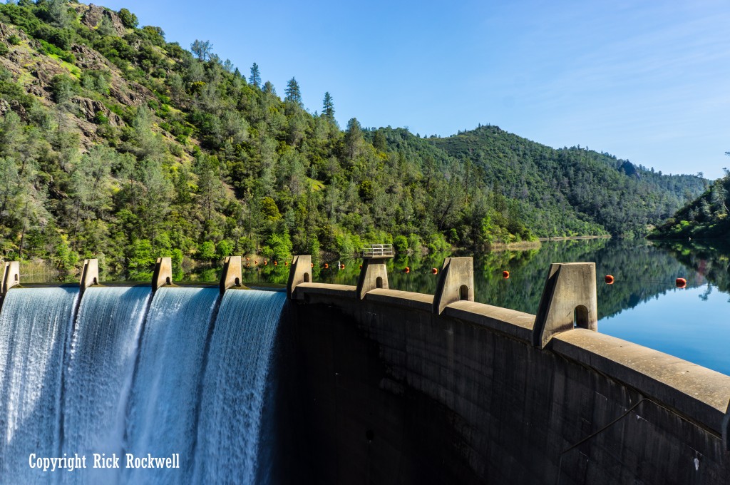
Auburn Dam And The Unfinished Project Story
Auburn Dam is one of the park’s defining historical threads. Lands in the canyon were acquired to support construction, operation, and maintenance of Auburn Dam and Reservoir, and the project was authorized in 1966 before later concerns and changing priorities halted it.
Auburn State Recreation Area Historic Bridges
Between major highway infrastructure, historic railroad engineering, and remote river crossings tied to old Gold Country routes, the bridges in Auburn SRA not only connect one side of the river to the other, but they also connect the outdoor landscapes with its deeper transportation and mining history.
Foresthill Bridge
Foresthill Bridge is the most visually dominant bridge in Auburn State Recreation Area, and the Foothills. It rises 730 feet above the American River, making it the highest bridge in California.
Mountain Quarries Railroad Bridge (No Hands Bridge)
No Hands Bridge, formally the Mountain Quarries Railroad Bridge, is a concrete arched bridge that’s listed on the National Register of Historic Places. It’s also one of the most photographed ASRA locations.
Iowa Hill Bridge
The historic Iowa Hill Bridge, and the “newer” bridge, are key crossings over the American River near the Mineral Bar region and lead to the historic, California ghost town of Iowa Hill.
Yankee Jims Bridge
Yankee Jims Bridge is another important crossing in the upper North Fork portion of Auburn SRA. Its purpose was for traffic to get to the old ghost town of Yankee Jims, which was named after the urban legend of Yankee Jim Robinson. Currently, there’s a new Yankee Jims Bridge being built, while the old one will be preserved as a foot bridge. Check current closure before visiting Yankee Jims.
Ponderosa Bridge
Ponderosa Bridge is one more major crossing associated with the upper North Fork section of the park. It’s also located at a small trailhead that leads to Codfish Falls.
Best Time To Visit Auburn State Recreation Area
The ASRA is a wonderful outdoor choice no matter what season it is. I have visited this park in every season and each time provided unique experiences.
Spring allows you to see blooming wildflowers, fuller creeks, and peak flow for waterfalls. The Summer is arguably the most ideal time due to the water activities. But this requires more planning and preparation.
The Fall provides some changes in color and a reprieve from the heat. Longer hikes become more enjoyable, as well. Winter can be quieter and greener, though access and conditions can vary more depending on recent weather.
Is Auburn State Recreation Area worth visiting?
Auburn State Recreation Area is one of my favorite “local” outdoor regions to visit no matter the season. I love taking friends and family here for their first time as they always gush over the park’s beauty and ruggedness, along with feeling rejuvenated from a fun time in the river canyons.
Hiking along the American River has been a favorite of mine since I was a kid. In the ASRA, you can also bike, ride horses, camp, raft, cross over cool bridges, view layers of distinct historic periods, and picnic along the river.
For me, I absolutely love the blend of history and scenery. It’s rich in Gold Rush lore, transportation evolution, and old stage coach roads. The options for adventure and outdoor fun rivals most regional or state parks in California.
Despite visiting ASRA for many years now, there are still parts of this park that I have yet to see. And, every time I visit this wonderful park, I feel like each experience is different than the previous ones.
I’ve hiked many popular trails, enjoyed the mist of North Fork Dam, cooled off in swimming holes, photographed historic points of interest, crossed old bridges by foot, chased waterfalls, and traversed the old stagecoach roads with the excitement of a kid.
The Auburn State Recreation Area is a must-visit location for anyone near Sacramento and the Foothills.
FAQ About Auburn State Recreation Area
What is Auburn State Recreation Area known for?
Auburn State Recreation Area is best known for its deep American River canyons, broad trail network, whitewater recreation, swimming areas, Lake Clementine, and strong Gold Country history.
Are there waterfalls in Auburn State Recreation Area?
Yes. The official park map identifies named waterfalls including Codfish Falls, Chamberlain Falls, and Kanaka Falls. There’s also the Black Hole of Calcutta Falls and the North Fork Dam.
Can you swim in Auburn State Recreation Area?
Yes, swimming is one of the park’s biggest warm-weather draws. Visitors often head to places like the Confluence area, Lake Clementine access points, and river bars along the American River like Clarks Hole.
Can you camp in Auburn State Recreation Area?
Yes. Auburn SRA has primitive camping at Mineral Bar, Ruck-A-Chucky, and Lake Clementine Boat-In Campground. These campgrounds are more rugged than resort-style campgrounds, so visitors should expect a more basic outdoor experience.
Are dogs allowed in Auburn State Recreation Area?
Dogs are allowed in much of Auburn State Recreation Area, but they are not allowed at Lake Clementine. Since rules can vary by zone, it is smart to check the specific area you plan to visit before heading out.
Is Auburn State Recreation Area good for kids and families?
Yes, but some areas work better than others. Families looking for easier access will generally do better focusing on shorter hikes, scenic river areas, and Lake Clementine-oriented outings rather than steep or exposed canyon climbs during hot weather.
How much does it cost to visit Auburn State Recreation Area?
A standard vehicle day-use fee ($10) is typically charged in the main fee areas.
Is Auburn State Recreation Area only for hikers?
No. Hiking is one of the main draws, but the park also supports mountain biking, horseback riding, boating, fishing, rafting, camping, swimming, and off-highway vehicle use in designated areas.
Recent Auburn State Recreation Posts
June 4, 2026
Auburn Waterfalls: Best Waterfall Hikes Near Auburn, California
Auburn is one of the best waterfall areas near Sacramento, but the waterfalls here do not all fit...
June 3, 2026
Foresthill Bridge: California’s Tallest Bridge Over the American River
Few landmarks in the foothills make you feel the scale of the American River canyon like Foresthill...
May 30, 2026
No Hands Bridge in Auburn: Visiting the Historic Mountain Quarries Bridge
No Hands Bridge is one of Auburn State Recreation Area’s most recognizable landmarks, a historic...
May 25, 2026
Black Hole of Calcutta Falls Guide: Auburn SRA Hike
Black Hole of Calcutta Falls is one of Auburn’s easiest waterfall hikes, but its unique name...
May 25, 2026
Lake Clementine Trail: A Guide to Auburn’s Best Waterfall Hike
Lake Clementine Trail is one of Placer County’s most rewarding hikes, leading from the North Fork...
May 23, 2026
Bunch Canyon Falls: A Rugged Gold Rush Waterfall Near Colfax, California
Bunch Canyon Falls is not the biggest Auburn waterfall in Placer County, and it is...
Sources
California State Parks – Auburn State Recreation Area overview: https://www.parks.ca.gov/?page_id=502
California State Parks – Auburn SRA Trails: https://www.parks.ca.gov/?page_id=1345
California State Parks – Auburn SRA General Plan / Resource Management Plan: https://www.parks.ca.gov/pages/21299/files/Part_1_3%20ASRA_APL_GP_RMP.pdf
California State Parks – Auburn SRA brochure map: https://www.parks.ca.gov/pages/502/files/ASRA_Brochure_Map_UPDATED_2021.pdf
California State Parks – Auburn SRA brochure: https://www.parks.ca.gov/pages/502/files/AuburnSRAFinalWebLayout2016_Flood_Rd_EDIT_12_31_20.pdf
California State Parks – Lake Clementine: https://www.parks.ca.gov/?page_id=1141
Canyon Keepers – Codfish Falls Trail Guide: https://www.canyonkeepers.org/tgcod.pdf
Placer Land Trust – Codfish Falls Trail Preserve: https://placerlandtrust.org/codfish-falls-trail-preserve/
CA Creeks – North Fork American River whitewater information: https://www.cacreeks.com/amer-nch.htm
National Park Service NPGallery – Mountain Quarries Railroad Bridge nomination: https://npgallery.nps.gov/NRHP/GetAsset/NRHP/04000014_text

Rick Rockwell

June 15, 2026
Haunted Cemeteries in California: Ghost Stories, Legends, and Historic Graveyards
Haunted cemeteries feel different because the legends are tied to things you can still see today:...
June 14, 2026
Mare Island: History, Attractions, Tours, and Things to Do
Mare Island does not feel like a normal California historic site. There is no single entrance gate...
CalEXPLORnia
Don’t Just Visit, Explore the History, Mystery, Landscapes, Legends and Lore of California!