Grouse Ridge Trailhead is the common visitor’s name for the hiking access area near Grouse Ridge Campground, high on Grouse Ridge in Tahoe National Forest. The road is rough, the facilities are primitive, and the final approach can feel slower than the mileage suggests.
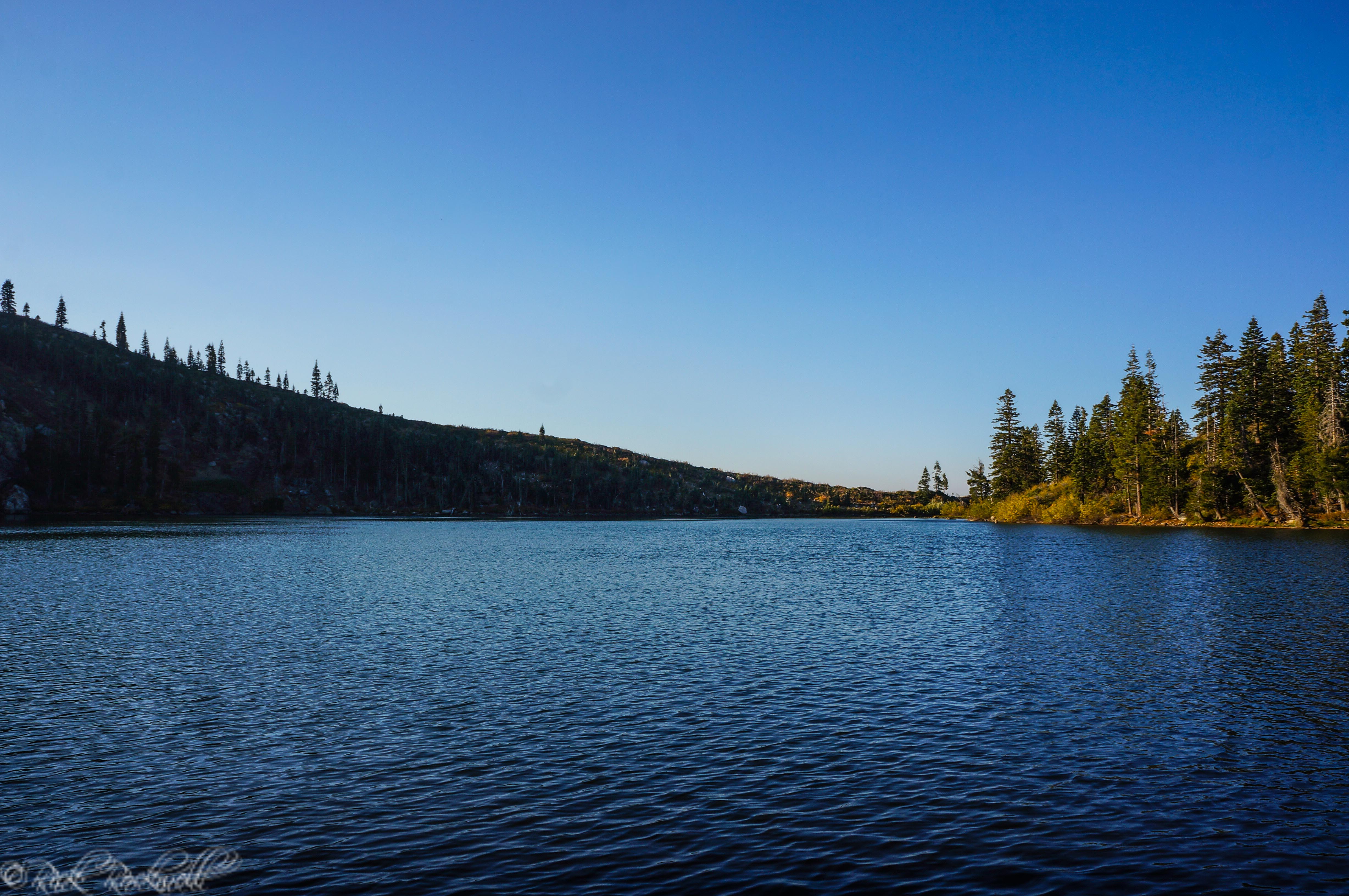
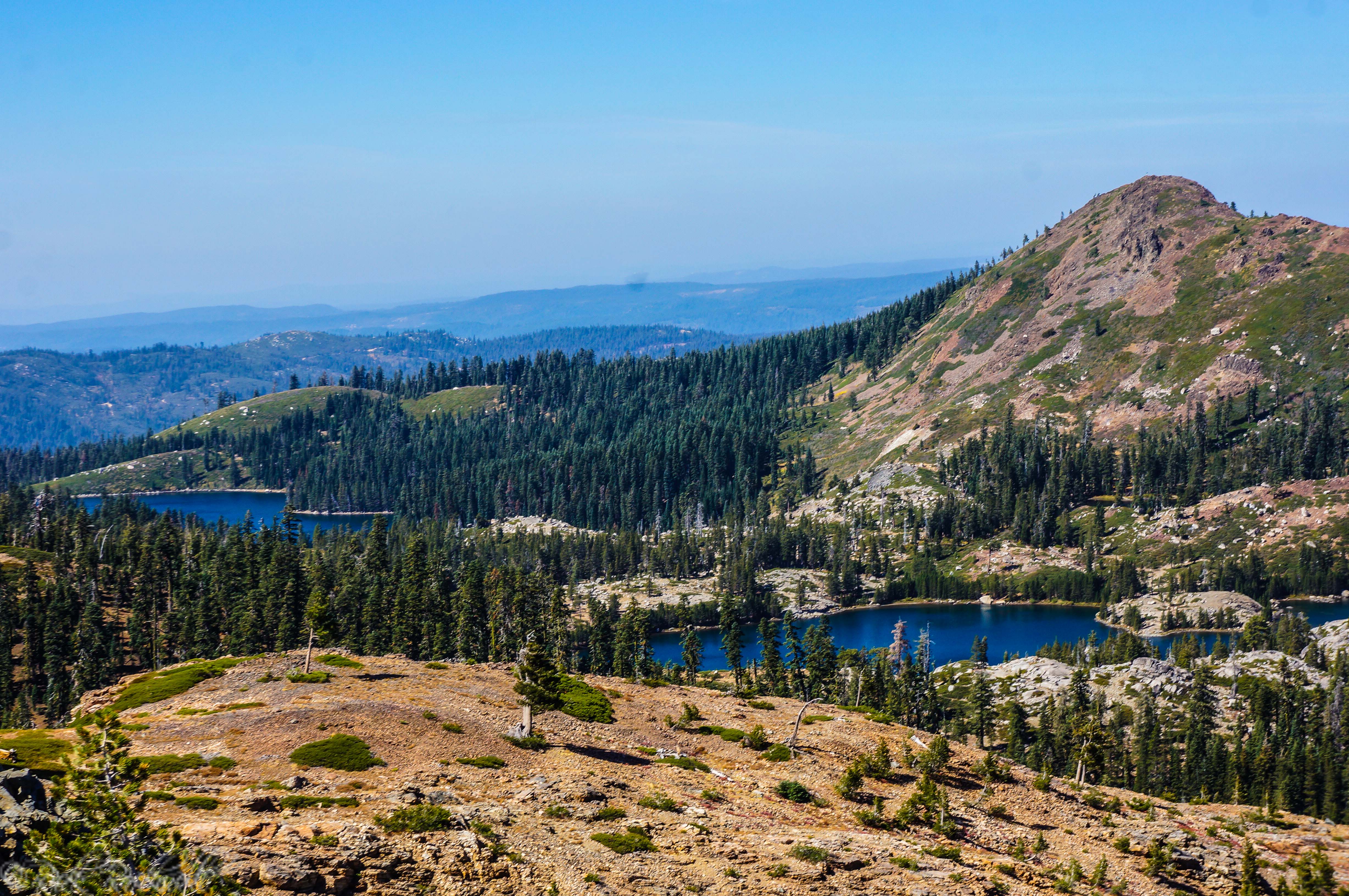
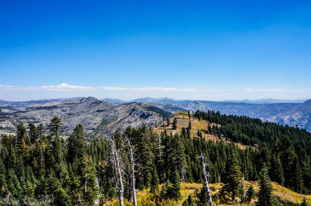
But once you are up on the ridge, the payoff is worth it: open Sierra views, granite, scattered pines, alpine lakes below the ridge, and access to some of the most interesting routes in the Grouse Lakes Area.
This guide covers how to get there, what to expect at the trailhead, staying overnight at Grouse Ridge Campground, a comparison to nearby Carr Lake Trailhead, and the main hikes that start from this rough but rewarding access point.
Quick Facts About Grouse Ridge Trailhead
- Location: Tahoe National Forest, north of Highway 20 near Bowman Lake Road.
- Access: Bowman Lake Road / FR 18 to Grouse Ridge Road / FR 14.
- Road: Final 6 miles are rough, unimproved dirt; a high-clearance vehicle is strongly recommended.
- Elevation: About 7,400 feet near Grouse Ridge Campground.
- Facilities: Vault toilet, 9 primitive campsites, bear boxes, no potable water, no trash service.
- Fees: No campground fee listed by the Forest Service.
- Best season: Summer into early fall, depending on snow and road conditions.
- Best for: Grouse Ridge Lookout, Glacier Lake, Sand Ridge, ridge views, and longer Grouse Lakes routes.
Where Is Grouse Ridge Trailhead?
Grouse Ridge Trailhead is in Tahoe National Forest, north of Highway 20, in the Yuba River Ranger District. It sits above the Grouse Lakes Area, near a cluster of primitive campgrounds, alpine lakes, granite ridges, and non-motorized trails.
How to Get to Grouse Ridge Trailhead
From the Nevada City side, the Forest Service directions route visitors east on Highway 20 toward Truckee for about 20 miles, then north on Bowman Lake Road / Forest Road 18. After about 5 miles on Bowman Lake Road, turn right on Grouse Ridge Road / Forest Road 14. From there, the road is unimproved dirt for about 6 miles to Grouse Ridge Campground.
From the I-80 side, take the Highway 20 cutoff west for about 5 miles, turn right on Bowman Lake Road / Forest Road 18, continue about 5 miles, then turn right on Grouse Ridge Road / Forest Road 14. The same rough 6-mile dirt-road approach leads to the campground/trail access area.
Road Conditions and Vehicle Advice
Grouse Ridge Campground sits at the end of a 6-mile unimproved dirt road, and the broader Bowman Road area includes rough, rocky driving. A high-clearance vehicle is strongly recommended, and 4WD may be useful depending on current conditions.
Road conditions can change with snowmelt, storms, washouts, rocks, and ruts, so do not rely only on map-app drive times. Check Tahoe National Forest alerts before going, avoid the road in bad weather, and turn around if the drive exceeds your vehicle or comfort level.
Grouse Ridge Trailhead Parking, Bathrooms, and Water
Grouse Ridge Trailhead is a primitive access point, so plan like you are heading into a remote forest road area, not a developed day-use lot.
Parking is informal and limited around the small campground and trail access area. Arrive early on summer weekends, park only where it is safe and appropriate, and do not block roads, campsites, gates, or emergency access.
A vault toilet is available at Grouse Ridge Campground, but potable water is not. Bring all water needed for hiking, camping, pets, cooking, and emergencies.
There is also no trash service. Pack out all food waste, wrappers, toilet paper, dog waste, and campground trash.
Camping at Grouse Ridge Campground
Grouse Ridge Campground is the small primitive campground tied to the trailhead area. The Forest Service lists 9 campsites, with tables, fire rings, bear boxes, and a vault toilet. Five campsites have space for small trailers.
There is no piped water and no trash service, so campers need to bring all drinking water and pack out everything they bring in. The Forest Service lists no fee for Grouse Ridge Campground.
The listed season of use is Memorial Day to mid-October, but normal campground operation is Memorial Day weekend to Labor Day weekend, and weather can change that. The campground is also often late opening because of snowbanks on the access road.
Before camping, check current Tahoe National Forest alerts and fire restrictions. Campfire rules can change quickly in summer and fall, and campfire permits are required for campfires, charcoal fires, or portable gas stoves outside designated recreation sites.
Food storage matters here, too. Use the bear boxes where available and keep food, scented items, and trash secured.
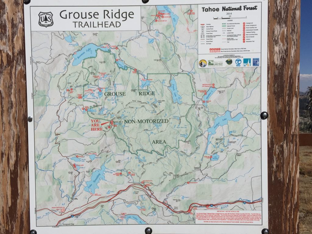
Grouse Ridge Trailhead map
Best Hikes from Grouse Ridge Trailhead
Grouse Ridge is less about one obvious hike and more about choosing the right route from a network of ridge paths, lake spurs, and longer backcountry connections. The trailhead works best when you know whether you want a quick view, a lake destination, or a longer route through the Grouse Lakes Area.
Route or destination | Best for | Trail note | Planning caution |
Grouse Ridge Lookout | Short payoff, views, photos | Near the Grouse Ridge access area | Verify current access and do not assume interior access |
Grouse Ridge Trail | Longer hiking and backpacking routes | Forest Service lists it as 8 1/8 miles from Eagle Lakes to Sawmill Lake | Official trail length is not the same as every route from the campground |
Glacier Lake Trail | Alpine lake destination, rugged feel | Forest Service lists Glacier Lake Trail as 2.3 miles one way from Grouse Ridge Trail to Glacier Lake | You cannot drive to this trail; access is by trail |
Sandridge Lake Trail | Ridge views and loop potential | Forest Service lists Sandridge Lake Trail as 2.6 miles along an open ridgeline | You cannot drive to this trail; access is from Grouse Ridge Trail or Round Lake Trail |
Glacier Lake / Sand Ridge loop | Stronger day hike or backpacking route | Forest Service recommends pairing Glacier Lake and Sandridge Lake Trail for a loop | Verify full mileage, junctions, and conditions before relying on a hiking app |
Longer Grouse Lakes routes | Backpackers and experienced hikers | The area connects multiple trails and lakes | Carry a map, check fire rules, and plan for exposed high-elevation terrain |
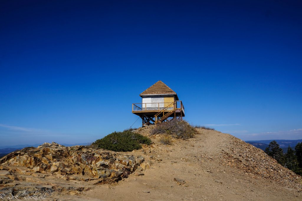
Grouse Ridge Lookout
Grouse Ridge Lookout is the quickest scenic payoff near the trailhead area. If you made the slow drive and want views without committing to a long lake route, this is the obvious first stop.
The Forest Fire Lookout Association lists Grouse Ridge as a standing Nevada County lookout and identifies it with National Historic Lookout Register listing numbers US 283 and CA 17. That gives the ridge a little more significance than just scenery; it also carries a piece of California fire-protection history.
The lookout gives the place a strong sense of destination. Even if you are not hiking far, the ridge views help explain why people put up with the road..
Grouse Ridge Trail
Grouse Ridge Trail is the main named trail in the area. The Forest Service lists it as 8 1/8 miles long, beginning at Eagle Lakes and ending at Sawmill Lake, and open for hiking and backpacking.
That official mileage is useful, but it can also be misleading if you are planning from the campground/trailhead area. Many hikers will not be walking the full official trail from end to end. Instead, they may use parts of Grouse Ridge Trail to reach other routes, loop options, lakes, or longer backcountry itineraries. Think of Grouse Ridge Trail as the backbone of the area rather than a single simple day hike.
Glacier Lake Trail
Glacier Lake Trail is one of the stronger destinations connected to the Grouse Ridge side of the trail network. The Forest Service lists the trail as 2.3 miles one way from Grouse Ridge Trail to Glacier Lake and describes it as moderate because of high elevation, continuous uphill grade, and loose granite rocks.
The key detail: you cannot drive directly to Glacier Lake Trail. You have to access it from Grouse Ridge Trail or Round Lakes Trail.
That makes Glacier Lake a better fit for hikers who are comfortable with route planning, trail junctions, and a more committed outing. It is not a casual drive-up lake stop.
Sandridge Lake Trail
Sandridge Lake Trail is a 2.6-mile route that follows the open Sand Ridge ridgeline. The appeal here is the view. The route looks toward Grouse Ridge Lookout, the Sierra Buttes, Black Buttes, and the lake basins around Five Lakes Basin and Grouse Ridge.
Like Glacier Lake Trail, this is not a drive-up trail. The Forest Service notes that hikers must access it from either Round Lake Trail or Grouse Ridge Trail.
Sandridge Lake Trail makes the most sense for hikers who want a higher, more scenic loop rather than a simple out-and-back. It can also feel more exposed than forested lake trails, so pay attention to weather, heat, wind, and afternoon storms.
Longer Backpacking Routes
Grouse Ridge also works as a jumping-off point for longer backpacking routes in the Grouse Lakes Area. Depending on your route, you may be connecting pieces of Grouse Ridge Trail, Glacier Lake Trail, Sandridge Lake Trail, Round Lake Trail, Crooked Lakes Trail, or other nearby lake routes.
Grouse Ridge Trailhead vs. Carr Lake Trailhead
The two trailheads overlap in the broader Grouse Lakes Area, but they answer different visitor questions. Use Grouse Ridge if you want the lookout, higher ridge views, Glacier Lake, Sand Ridge, a more rugged approach, and longer route combinations. Use Carr Lake if you want the simpler lake-hopping route.
Question | Choose Grouse Ridge Trailhead | Choose Carr Lake Trailhead |
Main goal | Lookout, ridge views, Glacier Lake, Sand Ridge, longer routes | Carr Lake, Feeley Lake, Island Lake, Round Lake, Long Lake, Milk Lake |
Road experience | Rougher high-ridge access with 6 miles of unimproved dirt road | Rough final 3 miles, but more direct for the lake chain |
Best for | Hikers and backpackers comfortable with rough access | Lake-hopping day hikers and overnighters |
Quick payoff | Grouse Ridge Lookout and high views | Carr/Feeley/Island Lake scenery |
Route style | Ridge-first, network-style, more planning needed | More obvious lake-to-lake progression |
Best article | This Grouse Ridge Trailhead guide | Carr Lake Trailhead guide |
Best Time to Visit Grouse Ridge Trailhead
The best time to visit Grouse Ridge Trailhead is usually summer into early fall, but snow controls the real calendar. The Forest Service lists Grouse Ridge Campground’s season of use as Memorial Day to mid-October, while also noting that the campground is often late opening because of snowbanks on the access road. Normal campground operation is Memorial Day weekend to Labor Day weekend, and weather can change that.
Before you go, check:
- Tahoe National Forest alerts
- Fire restrictions
- Road conditions
- Weather forecast
- Smoke forecast
- Current campground operation status
Is Grouse Ridge Trailhead Worth Visiting?
Grouse Ridge Trailhead is worth visiting if you want high Sierra views, a historic lookout, primitive camping, and trail options that feel more rugged than a quick lake walk like Carr Lake or even other recreation areas like the Crystal Basin and Wrights Lake.
It is a rewarding access point for hikers who like planning their own route and do not mind a slow, rough road before the hike even begins.
It is not the right fit for every visitor. If you have a low-clearance vehicle, limited time, or a main goal of reaching Island Lake or Round Lake by the simplest route, Carr Lake Trailhead is probably the better choice.
Grouse Ridge rewards the extra effort, but it asks for patience and preparation before the hike even starts.
FAQs About Grouse Ridge Trailhead
Is the road to Grouse Ridge Trailhead rough?
Yes. The final approach to Grouse Ridge Campground is about 6 miles of unimproved dirt road. The broader Bowman Road area includes rocky, rough unpaved sections. A high-clearance vehicle is strongly recommended, and 4WD may be useful depending on current conditions.
Do you need 4WD for Grouse Ridge Trailhead?
A high-clearance vehicle is strongly recommended, and 4WD may be useful depending on current road conditions. Check with Tahoe National Forest before going and avoid the drive if conditions exceed your vehicle or comfort level.
Is there a bathroom at Grouse Ridge Trailhead?
Yes. A vault toilet is available near Grouse Ridge Campground.
Is there water at Grouse Ridge Trailhead?
No. Potable water is not available at Grouse Ridge Campground. Bring all water needed for hiking, camping, pets, and emergencies.
Is there a fee to park or camp at Grouse Ridge?
The Forest Service lists no fee for Grouse Ridge Campground. Always verify current fee, pass, and operation details before visiting.
Can you hike to Grouse Ridge Lookout from the trailhead?
Yes, Grouse Ridge Lookout is one of the main nearby features from the Grouse Ridge access area. Check current conditions and access details before assuming the lookout interior is open.
Can you hike to Glacier Lake from Grouse Ridge Trailhead?
Yes, but Glacier Lake is not a drive-up destination. The Forest Service lists Glacier Lake Trail as a 2.3-mile one-way trail from Grouse Ridge Trail to Glacier Lake, so you need to account for the approach and return route when planning your full hike.
Can you hike Sand Ridge from Grouse Ridge Trailhead?
Yes, Sandridge Lake Trail can be accessed from Grouse Ridge Trail or Round Lake Trail. The Forest Service lists it as a 2.6-mile ridgeline route with views of Grouse Ridge Lookout, the Sierra Buttes, Black Buttes, and nearby lake basins.
When is Grouse Ridge Trailhead open?
The campground season of use is listed as Memorial Day to mid-October, but the area can open late because of snowbanks on the access road. Normal campground operation is Memorial Day weekend to Labor Day weekend, and weather can change that. Check Tahoe National Forest current conditions before visiting.
Sources
USDA Forest Service — Grouse Ridge Campground — https://www.fs.usda.gov/r05/tahoe/recreation/grouse-ridge-campground
USDA Forest Service — Bowman Road — https://www.fs.usda.gov/r05/tahoe/recreation/bowman-road
USDA Forest Service — Grouse Ridge Trail — https://www.fs.usda.gov/r05/tahoe/recreation/trails/grouse-ridge-trail
USDA Forest Service — Glacier Lake Trail — https://www.fs.usda.gov/r05/tahoe/recreation/trails/glacier-lake-trail
USDA Forest Service — Sandridge Lake Trail — https://www.fs.usda.gov/r05/tahoe/recreation/trails/sandridge-lake-trail
USDA Forest Service — Carr Lake Campground — https://www.fs.usda.gov/r05/tahoe/recreation/carr-lake-campground
USDA Forest Service — Tahoe National Forest Alerts — https://www.fs.usda.gov/r05/tahoe/alerts
USDA Forest Service — Tahoe National Forest Permits — https://www.fs.usda.gov/r05/tahoe/permits
USDA Forest Service — Tahoe National Forest Motor Vehicle Use Maps — https://www.fs.usda.gov/r05/tahoe/maps-guides/motor-vehicle-use
Bear Yuba Land Trust — BYLT Secures Protection of 857 Acres in Grouse Ridge — https://www.bylt.org/bylt-secures-protection-of-857-acres-in-grouse-ridge/
Forest Fire Lookout Association — California Lookouts — https://firelookout.org/lookouts/us/ca/ca-co