Auburn is one of the best waterfall areas near Sacramento, but the waterfalls here do not all fit into one convenient category. Some are developed park destinations with viewing decks. Some are natural waterfall hikes in the American River canyon. Some are roadside-style seasonal falls along old Gold Country roads. Others are obscure, rugged, or difficult to reach.
That variety is what makes waterfall chasing around Auburn a thrilling experience. You can plan an easy family-friendly outing at Hidden Falls, hike through the North Fork American River canyon to Codfish Falls, photograph the dramatic cascade at Lake Clementine / North Fork Dam, or explore rougher Yankee Jims Road waterfalls when access is open.
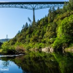
Auburn State Recreation Area, often shortened to ASRA, is the canyon landscape behind many of the best waterfall trips near Auburn. The park follows roughly 40 miles of the North and Middle Forks of the American River, stretching from Auburn toward Colfax, with hiking, river access, boating, fishing, camping, mountain biking, horseback riding, gold panning, OHV use, and whitewater recreation all part of the area’s draw.
That mix of river canyons, seasonal creeks, old roads, and rugged foothill terrain is why so many Auburn waterfalls feel different from one another. Some are easy park visits, some are canyon hikes, and others are rougher backroad stops tucked into the edges of ASRA.
Best Auburn Waterfalls at a Glance
Best For | Waterfall | Why |
Best first-time waterfall stop | Hidden Falls | Most developed, easiest to plan, and best for families or first-time visitors |
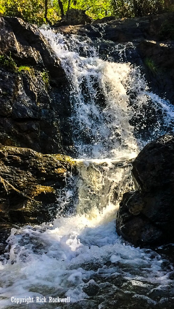
Best true waterfall hike | Codfish Falls | Natural waterfall payoff with North Fork American River scenery |
Best photo spot | Lake Clementine / North Fork Dam | Biggest waterfall-like cascade near Auburn, but man-made |
Easiest roadside-style waterfall, when access is open | Devils Falls | Roadside Yankee Jims Road waterfall |
Most unique Auburn-area waterfall | Bunch Canyon Falls | Rougher canyon setting with nearby wrecked cars and an unusual backroad feel |
Auburn Waterfall Safety Tips
Auburn waterfall hikes can look simple on a map, but foothill canyons, dirt roads, seasonal creeks, and heat can change the experience quickly. Check official park, road, and weather closures before leaving, especially for Hidden Falls, Lake Clementine, and Yankee Jims Road areas.
Hidden Falls requires parking reservations on weekends, peak-use days, and marked holidays, and permits are not sold at the park. Codfish Falls visitors should check Ponderosa Way conditions because the final road section is dirt, unmaintained, and better suited for high-clearance vehicles.
Lake Clementine / North Fork Dam hikers should understand that the dam-view hike, Upper Lake Clementine Day-use area, and Lower Lake Clementine boat-in camping area have different access rules. Dogs are not allowed at Lake Clementine.
Devils Falls, Mexican Gulch Falls, and Bunch Canyon Falls are affected by the Yankee Jims Road bridge project, so check current road closures before planning around those waterfalls.
Avoid waterfall hikes right after major storms, when creeks, rivers, dirt roads, and steep canyon trails can become dangerous. Do not climb around dams, wet rocks, closed areas, fast-moving water, or wrecked vehicles. Expect poison oak, ticks, snakes, heat, limited shade, and uneven footing on many Auburn-area trails.
Best Waterfalls in and Near Auburn, CA
Auburn’s waterfall scene ranges from easy park trails to rough canyon stops. Here’s how the best options compare.
Hidden Falls
Detail | Info |
Location | Hidden Falls Regional Park – 7587 Mears Pl, Auburn, CA 95603 |
Best for | Families, first-time visitors, easy waterfall planning |
Route distance | Hidden Falls Access Trail is a 3-mile loop; Seven Pools Loop is 4.5 miles; the park also has a quarter-mile paved ADA-accessible trail |
One-way or round trip? | Loop routes |
Difficulty | Easy to moderate, depending on route |
Dogs | Allowed on leash |
Parking | Reservation required on all weekends, peak-use days, and marked holidays |
Fee / reservation | Parking permit required on reservation days; permits are not sold at the park |
Best season | Winter through spring |
Hidden Falls is the best overall Auburn waterfall for most first-time visitors and families. It has the simplest planning setup, a real trail system, viewing decks, restrooms, picnic areas, and enough infrastructure to work for families, casual hikers, photographers, trail runners, and visitors who do not want to gamble on rough canyon roads.
The park is not one fixed hike; it has over 30 miles of native-surface multi-use trails, a quarter-mile concrete ADA-accessible trail, falls viewing decks, picnic areas, restrooms, open space, and horse trailer parking. Official sources list the Hidden Falls Access Trail as a 3-mile loop and the Seven Pools Loop as a 4.5-mile trail.
The biggest planning detail is parking. Reservations are required on all weekends and on listed 2026 high-use dates. Parking permits must be purchased before visiting and are not available at the park.
Hidden Falls is one of my favorite regional parks near Auburn because the layout, trail system, and amenities all work together so well. The viewing areas are easy to find, the trails can be adjusted for a shorter or longer outing, and the park feels much easier to plan than many of the rougher canyon waterfalls nearby. I highly recommend visiting in spring, when the water flow is stronger and the surrounding foothills are green, bright, and full of seasonal color.
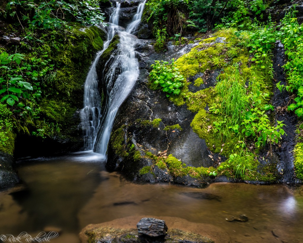
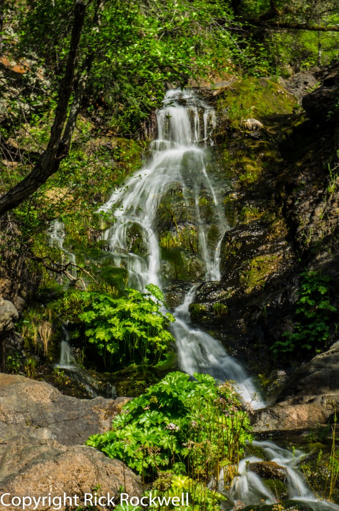
Codfish Falls
Detail | Info |
Location | Weimar / North Fork American River canyon |
Best for | Best true waterfall hike near Auburn |
Route distance | 1.7 miles one way to the falls; about 3.4 miles round trip |
One-way or round trip? | Out and back |
Difficulty | Easy trail, but road access is the bigger issue |
Dogs | Generally allowed in Auburn SRA areas outside Lake Clementine |
Parking | Ponderosa Way trailhead |
Road warning | Last 2.5 miles of Ponderosa Way are dirt and unmaintained; high-clearance vehicles recommended |
Fee / reservation | Auburn SRA day-use rules may apply |
Best season | Spring |
Codfish Falls feels more like a true canyon waterfall hike than some of the easier Auburn-area stops. The trail follows the North Fork American River canyon, with river views, narrow sections, spring greenery, and a 40-foot waterfall waiting at Codfish Creek.
I was surprised by the road getting there. The hike itself is not especially long, but the drive down Ponderosa Way makes the trip feel more remote before you even reach the trailhead. Once you start walking, the route feels like a real trek through the canyon landscape instead of a simple park trail.
The access road is the biggest thing to plan around. The final stretch of Ponderosa Way is dirt and unmaintained, so high-clearance vehicles are a better fit, especially after rain. In dry spring conditions, Codfish Falls is one of the best Auburn-area waterfall hikes. After heavy storms, the road can be a bigger issue than the trail, so check conditions before making the drive.
Lake Clementine / North Fork Dam
Detail | Info |
Location | Auburn State Recreation Area |
Best for | Big waterfall-like photo spot |
Route distance | Lake Clementine Trail is commonly listed at 1.9 miles to Lake Clementine Road; reaching the North Fork Dam viewing area adds extra distance, making the full hike about 4.6 miles round trip |
One-way or round trip? | Out and back |
Difficulty | Easy to moderate |
Dogs | Not allowed at Lake Clementine |
Parking | Limited Auburn SRA / Lake Clementine-area parking; do not confuse with Upper Lake Clementine day-use access |
Fee / reservation | State Parks day-use fees apply; Upper Lake Clementine has separate peak-season weekend reservation rules |
Best season | Winter through spring, when dam flow is stronger |
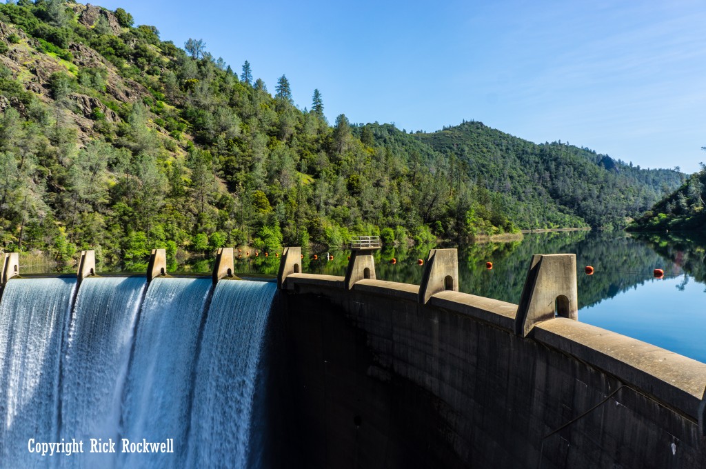
Lake Clementine / North Fork Dam is one of Auburn’s most photographed waterfall-like scenes, but it is not a natural waterfall. The cascade comes from water spilling over North Fork Dam, which creates the dramatic wall of water below Lake Clementine.
This is my favorite hike in Auburn and one of my favorite hikes near Sacramento. The route has river views, Clark’s Hole, canyon scenery, the dramatic Foresthill Bridge, and just enough climbing to feel like a real outing without turning into an all-day grind. In the heat, the hike can feel tiring, especially on the exposed sections, but the payoff at the dam is worth it.
When water is pouring over the dam, the scene feels bigger and louder than many of the smaller natural waterfalls around Auburn. The mist, rainbows, and echo of the water crashing down the concrete face make it one of the most memorable waterfall-style views in the area, no matter the season. Be careful climbing or walking on the rocks near the dam, as they are slippery.
This hike usually starts from the Confluence / Old Foresthill Road side and follows Lake Clementine Trail toward the North Fork Dam view. That is different from planning a day-use, swimming, boating, or launch visit to Upper Lake Clementine, which has separate access, parking, seasonal rules, and fee details.
For distance, plan on about 4.6 miles round trip from the Confluence / Old Foresthill Road side to the dam-view area and back. Lake Clementine Trail itself is commonly listed at 1.9 miles to Lake Clementine Road, but reaching the North Fork Dam view adds extra walking.
Dogs are not allowed at Lake Clementine, even though they are allowed in many other parts of Auburn State Recreation Area. For photographers, first-time Auburn visitors, and hikers who want the biggest visual payoff near Auburn, Lake Clementine / North Fork Dam is the best choice. It’s rugged beauty is unmatched by any other waterfall in or near Auburn.
Devils Falls
Detail | Info |
Location | Yankee Jims Road area, near Colfax / Auburn SRA |
Best for | Easiest roadside-style Auburn-area waterfall when access is open |
Route distance | Roadside-style stop when Yankee Jims Road access is open |
One-way or round trip? | Not a standard maintained hike |
Difficulty | Easy when road access is open, but current road closure changes access |
Dogs | Verify current road, trail, and Auburn SRA rules before going |
Parking | Roadside / limited area access when open |
Road warning | Yankee Jims Road is currently closed between Gillis Hill Road and Shirttail Canyon Road during bridge replacement |
Best season | Winter through spring |
Devils Falls is one of the easiest Auburn-area waterfalls to appreciate when Yankee Jims Road is open. It does not feel like a traditional hike as much as a rugged Gold Country roadside stop, with the waterfall dropping through the canyon right along the old road between the Colfax and Foresthill sides of Auburn State Recreation Area.
When I visited, the appeal was not just the waterfall itself, but the whole setting around it. Yankee Jims Road has that narrow, backroad canyon feel, and Devils Falls fits perfectly into that landscape. It feels tucked away, rough around the edges, and much more old-school than a developed park waterfall like Hidden Falls.
The falls are seasonal, so winter and spring are the best times to see real flow. In drier months, the canyon is still interesting, but the waterfall, which is 50 to 75 feet in height, can be much weaker or nearly gone.
The current road closure is the biggest planning issue. Currently, Yankee Jims Road is closed between Gillis Hill Road and Shirttail Canyon Road during the bridge replacement project, which began May 19, 2025 and is expected to require a three-year construction closure.
This means that you can’t visit the Yankee Jims Bridge or any waterfalls along the YJR until the construction has been completed. However, you can still visit the old Gold Rush town of Yankee Jims and also learn more about the urban legend of Yankee Jim Robinson, who the town, bridge and road are named after.
Bunch Canyon Falls
Detail | Info |
Location | Bunch Canyon / Yankee Jims Road area near Colfax |
Best for | Most unique Auburn-area waterfall |
Route distance | Short but difficult off-trail descent; roughly 1,000 feet from road to creek |
One-way or round trip? | Unofficial out-and-back route |
Difficulty | Difficult despite the short distance |
Dogs | Not recommended |
Parking | Small roadside area when access is open |
Road warning | Yankee Jims Road closure currently affects access |
Best season | Spring |
Bunch Canyon Falls is the strangest waterfall stop, and that is what makes it so memorable. It is not the easiest Auburn-area waterfall to access, and it is not the prettiest in a clean, postcard-style way. The appeal is the whole scene: the rough canyon, the seasonal waterfall, the old backroad feel, and the wrecked cars nearby that make the place feel eerie and forgotten.
When I visited, the route felt more like an off-trail scramble than a normal waterfall hike. There is no signed trail, no easy overlook, and no simple walk-up viewpoint. The distance from the road to the creek is about 1,000 feet, but the drop down to the creek is very steep and much more difficult than the distance suggests.
That strange setting is also the warning. Expect loose footing, brush, poison oak, and rough unofficial terrain. The wrecked cars add to the atmosphere, but they should be treated as hazards, not something to climb on or explore.
Bunch Canyon Falls is best for experienced hikers who are comfortable with route-finding, steep terrain, and turning around if conditions feel sketchy. It is not a good choice for families, casual visitors, dogs, or anyone expecting a maintained trail.
Yankee Jims Road access is also affected by the bridge replacement project, so check current closure updates before planning around Bunch Canyon Falls.
Mexican Gulch Falls
Detail | Info |
Location | Yankee Jims Road area, near Colfax / Auburn SRA |
Best for | Seasonal companion waterfall to Devils Falls |
Route distance | Short roadside-area waterfall stop when access is open |
One-way or round trip? | Not a standard maintained trail hike |
Difficulty | Easier than many off-trail Auburn-area waterfall hunts when road access is open |
Dogs | Verify current road, trail, and Auburn SRA rules before going |
Parking | Limited roadside-style access when open |
Road warning | Yankee Jims Road closure currently affects access |
Best season | Winter through spring |
Mexican Gulch Falls has that half-hidden Yankee Jims Road feel, where you round a bend and suddenly the canyon gives you something worth stopping for. It is a smaller seasonal fall, dropping in two modest tiers, but the setting gives it more character than the size suggests. The narrow road, rough canyon walls, and old backroad atmosphere make it feel like a classic Placer County roadside discovery rather than a planned waterfall hike.
When I visited, Mexican Gulch Falls felt like one of those easy-to-miss roadside surprises that makes exploring the Auburn and Colfax backroads so rewarding. The waterfall drops in two modest tiers, and while it is not as dramatic as Codfish Falls or Lake Clementine / North Fork Dam, it has a quieter charm that stands out in this YJR are like an oasis in the desert.
Timing matters here. Mexican Gulch Falls is at its best in winter or spring, when the creek has enough flow to make the stop worthwhile. In dry weather, it can fade quickly, so this is not a waterfall to build a whole day around by itself.
The biggest issue right now is access. Yankee Jims Road is closed between Gillis Hill Road and Shirttail Canyon Road during the bridge replacement project, so Mexican Gulch Falls will require patience before accessing this location.
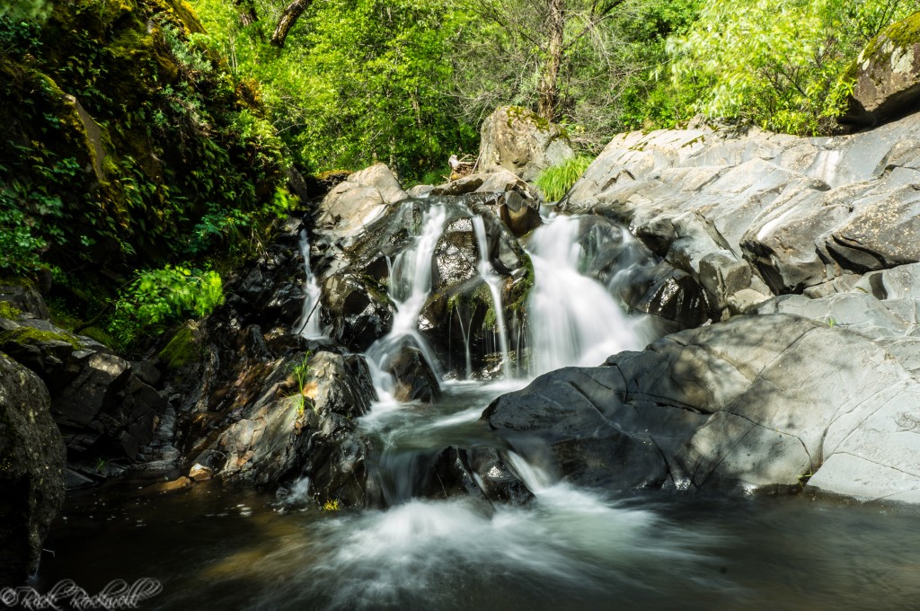
Black Hole of Calcutta Falls
Detail | Info |
Location | Auburn SRA / Confluence area |
Best for | Short Confluence-area Auburn waterfall hike |
Route distance | About 2.2 miles round trip |
One-way or round trip? | Out and back |
Difficulty | Easy |
Dogs | Generally allowed in Auburn SRA areas outside Lake Clementine; verify current leash rules |
Parking | Confluence-area parking / Auburn SRA access |
Fee / reservation | Auburn SRA day-use fees may apply |
Best season | Late winter through spring |
Black Hole of Calcutta Falls is more of a small canyon reward than a major waterfall destination, but that is part of its appeal. When I hiked it, the waterfall itself was not the only reason the route or itinerary worked.
The trail has that classic Auburn Confluence feel: river-canyon scenery, old railroad-grade walking, rocky slopes, and enough history around No Hands Bridge, also known as Mountain Quarries Railroad Bridge, to make the whole area feel worth exploring.
Like most waterfalls in the Auburn area, Calcutta Falls timing really matters. In late winter or spring, Black Hole of Calcutta Falls can feel like a fun destination. In summer or fall, the water may be weak or gone, so the hike becomes more about the bridge, the trail corridor, the American River Confluence, and the surrounding canyon views.
That makes it different from Codfish Falls or Hidden Falls. I would not plan an entire Auburn waterfall day around Black Hole of Calcutta Falls by itself, but it works well as a short Confluence-area hike, especially if you want to add No Hands Bridge, the Western States Trail, or a river stop before or after.
Best Time to See Waterfalls Near Auburn
Season can make or break an Auburn waterfall trip, especially for the smaller creek-fed falls. The best time to see Auburn waterfalls is usually late winter through spring, especially after steady rain and before the foothills turn hot and dry.
February through May are often the ideal months to target if the goal is actual waterfall flow instead of just a pleasant hike. Spring is especially strong because the hills are green, seasonal creeks are more likely to be running, wildflowers may be out, and temperatures are usually more comfortable than summer.
Auburn State Recreation Area can get hot, with summer temperatures commonly in the high 80s to mid-90s, while winters are wet and cooler.
Summer is better for river access, swimming holes, and early-morning hikes than waterfall flow. By late summer and fall, many smaller drainages around Auburn may be weak or dry unless early storms have arrived.

More Auburn-Area Waterfalls to Know
Beyond the main waterfall stops, the Auburn region has various-sized seasonal falls and harder-to-reach canyon cascades. These are worth knowing about, but most require better timing, more route research, or more caution than the top picks above.
Worth Knowing, But Not First Picks
These waterfalls are legitimate Auburn-area or nearby Placer County stops, but most visitors should treat them as secondary options:
- Mile Hill Creek Falls: A lesser-known Auburn waterfall, best treated as seasonal.
- Paradise Canyon Falls: Another obscure Auburn-area seasonal waterfall.
- Slug Gulch Falls: A real Auburn listing with a Gold Country-style name, but not a mainstream visitor stop.
- Jefferson Canyon Falls: A Weimar-area waterfall that fits naturally near Codfish Falls.
- Pennyweight Falls: A Colfax-area waterfall that works better as a nearby add-on to visiting the Iowa Hill bridges or a drive along the wild Iowa Hill Road up to the living ghost town of Iowa Hill.
Advanced or Obscure Waterfalls
Some Auburn-area waterfalls are better left to experienced hikers who are comfortable checking maps, access, terrain, and current conditions before going. These include Drivers Flat Falls, Lower Drivers Flat Falls, Clipper Creek Falls, Upper Clipper Creek Falls, Shirttail Canyon Falls, Stevens Creek Falls, Quail Trap Ravine Falls, and Slaughter Ravine Falls.
Which Auburn Waterfall Should You Visit?
Use this table to choose the Auburn waterfall that best fits your day, whether you want an easy park visit, a real canyon hike, a quick roadside stop, or a rougher backroad adventure.
Visitor Type | Best Pick | Why |
First-time visitor | Hidden Falls | Easiest developed waterfall park near Auburn |
Best true waterfall hike | Codfish Falls | Natural waterfall, river canyon, and spring scenery |
Best photo spot | Lake Clementine / North Fork Dam | Biggest waterfall-like view near Auburn |
Easiest roadside-style waterfall, when access is open | Devils Falls | Roadside Yankee Jims waterfall, but currently access-affected |
Best Yankee Jims companion waterfall | Mexican Gulch Falls | Seasonal waterfall near Devils Falls |
Most unique Auburn-area waterfall | Bunch Canyon Falls | Rugged canyon setting with nearby wrecked cars |
Short Confluence-area hike | Black Hole of Calcutta Falls | Easy Auburn SRA hike near No Hands Bridge |
Dog-friendly waterfall outing | Hidden Falls or Codfish Falls | Do not bring dogs to Lake Clementine |
Waterfall collector | Mile Hill Creek, Paradise Canyon, Slug Gulch, Jefferson Canyon | Good for long-tail research, not first picks |
Advanced hiker | Drivers Flat, Clipper Creek, Shirttail Canyon | Research-heavy and not casual |
Auburn Waterfall Itineraries and Day Trip Routes
Auburn’s waterfalls cluster around a few main areas: Hidden Falls, the Confluence, Lake Clementine / North Fork Dam, the North Fork American River canyon, and Yankee Jims Road. Use these routes to plan a half-day visit, a photo-focused outing, or a full day of waterfall chasing when road and trail conditions line up.
Easy Half-Day Waterfall Trip
Start with Hidden Falls Regional Park, then head into Auburn for lunch or a walk through Old Town. This is the easiest plan for families, first-time visitors, and anyone who wants a waterfall outing without rough roads or route-finding.
Auburn Confluence Waterfall and Bridge Trip
Start near the American River Confluence, hike toward Black Hole of Calcutta Falls, then add No Hands Bridge, also known as Mountain Quarries Railroad Bridge. This is a good spring plan if you want a short seasonal waterfall, river-canyon scenery, and one of Auburn’s most recognizable historic bridge landmarks. The bridge is part of the Canyon Creek Trail route to Calcutta Falls, with the trailhead near the Confluence.
Lake Clementine / North Fork Dam Photo Trip
Hike Lake Clementine Trail from the Confluence / Old Foresthill Road side toward the North Fork Dam view, then add Foresthill Bridge views or a stop near the Confluence. This is the best choice for the biggest waterfall-like photo payoff near Auburn. Visit Placer places the Lake Clementine Trail trailhead at the Confluence-area access near Old Foresthill Road.
Yankee Jims Road Waterfall Trip
When Yankee Jims Road access reopens, Devils Falls, Mexican Gulch Falls, and Bunch Canyon Falls make a strong backroad waterfall route near Auburn. Devils Falls is the easiest roadside-style stop, Mexican Gulch adds another seasonal waterfall nearby, and Bunch Canyon Falls gives the route its rough, unusual canyon character. For now, treat this as a future route to research because Yankee Jims Road is closed between Gillis Hill Road and Shirttail Canyon Road during the bridge replacement project.
North Fork American River Canyon Trip
Use Codfish Falls as the main hike, then add Ponderosa Bridge and a Colfax stop afterward if you still have time and energy. The trailhead sits off Ponderosa Way near Ponderosa Bridge, and the drive is part of what makes the outing feel remote. From my experience, the final stretch of road is rough, unpaved, and better suited for high-clearance vehicles, especially if there has been recent rain.
Full-Day Auburn Waterfall Chasing Route
For a full Auburn waterfall day, start with the most remote or road-dependent stop first, then make the day easier as you work back toward Auburn. That way you handle the roughest driving and hiking while you still have energy, then finish with easier canyon stops, a picnic, or Old Town Auburn.
Begin with Codfish Falls in the morning if Ponderosa Way is dry and your vehicle can handle the dirt road. This is the best true waterfall hike near Auburn, and it is the one most affected by road conditions, so it makes sense to do it before the day gets hot or crowded. After the hike, take a short break near the North Fork American River or Ponderosa Bridge before heading back toward Auburn.
From there, drive toward the Auburn Confluence for the middle of the day. This is the best place to slow down, eat lunch, or have a simple picnic near the river before choosing your next stop. If you want the biggest photo payoff, hike toward Lake Clementine / North Fork Dam. If you want something shorter and easier, choose Black Hole of Calcutta Falls and pair it with No Hands Bridge.
End the day with the easiest option left: a Foresthill Bridge viewpoint, a walk around the Confluence, or dinner in Old Town Auburn. If you reserved parking at Hidden Falls, that can also work as the easier second half of the day, but it is better as its own half-day trip for most visitors.
When Yankee Jims Road reopens, a more unusual full-day route could focus on Devils Falls, Mexican Gulch Falls, and Bunch Canyon Falls along with Yankee Jims Bridge and a nearby swimming hole. That day-trip would be rougher and more backroad-focused, with roadside cascades, seasonal water, and the strange wrecked-car setting near Bunch Canyon. Until the road closure changes, keep that as a future waterfall-chasing route rather than the main plan.
FAQ About Auburn Waterfalls
What is the best waterfall near Auburn, CA?
Hidden Falls is the best choice for most first-time visitors because it has developed trails, viewing areas, restrooms, and easier planning. Codfish Falls is the better pick for a true canyon waterfall hike, while Lake Clementine / North Fork Dam has the biggest waterfall-like photo opportunity.
Are there waterfalls in Auburn, CA?
Yes. The best-known waterfalls in and near Auburn include Hidden Falls, Codfish Falls, Lake Clementine / North Fork Dam, Devils Falls, Mexican Gulch Falls, Bunch Canyon Falls, and Black Hole of Calcutta Falls.
What is the best Auburn hike to a waterfall?
Codfish Falls is the best true waterfall hike near Auburn. Hidden Falls is the easiest developed waterfall outing, and Black Hole of Calcutta Falls is a short seasonal waterfall hike near the Auburn Confluence.
When is the best time to see Auburn waterfalls?
Late winter through spring is usually best. Smaller seasonal waterfalls flow strongest after rain, while summer and fall can bring low water or dry conditions.
How long are the main Auburn waterfall hikes?
Hidden Falls routes vary, but the Hidden Falls Access Trail is a 3-mile loop. Codfish Falls is about 3.4 miles round trip. Lake Clementine / North Fork Dam is about 4.6 miles round trip to the dam-view area. Black Hole of Calcutta Falls is about 2.2 miles round trip.
Are dogs allowed on Auburn waterfall hikes?
Dogs are allowed at Hidden Falls on leash and in many parts of Auburn State Recreation Area, but they are not allowed at Lake Clementine. Always check current park rules before bringing a dog.
Are Devils Falls, Mexican Gulch Falls, and Bunch Canyon Falls open?
Access is affected by the Yankee Jims Bridge replacement project. Yankee Jims Road remains closed between Gillis Hill Road and Shirttail Canyon Road, so check current road and park closure updates before planning a trip to those waterfalls.
Sources
California State Parks — Auburn State Recreation Area: https://www.parks.ca.gov/?page_id=502
California State Parks — Lake Clementine: https://www.parks.ca.gov/?page_id=1141
California State Parks — Lake Clementine Dog Restrictions Order: https://www.parks.ca.gov/pages/502/files/690-043-2026%20Dog%20Restrictions%20Lake%20Clementine%20-%20Auburn%20Sector.pdf
California State Parks — Yankee Jims Bridge Closure Order: https://www.parks.ca.gov/pages/502/files/690-055-2026%20Closure%20Yankee%20Jims%20Bridge.pdf
Placer County — Hidden Falls Regional Park: https://www.placer.ca.gov/hiddenfalls
Placer County — Hidden Falls Trails: https://www.placer.ca.gov/10017/Hidden-Falls-Trails
Placer County — Yankee Jims Bridge Replacement Progress: https://www.placer.ca.gov/10695/Yankee-Jims-Progress
Placer County — Historic Yankee Jims Bridge Project Set to Begin: https://www.placer.ca.gov/10266/Historic-Yankee-Jims-Bridge-project-set-
Yankee Jims Bridge Replacement Project: https://www.yankeejimsbridge.com/
Visit Placer — Codfish Falls Trail: https://www.visitplacer.com/discover/codfish-falls-trail/
Visit Placer — Lake Clementine Trail: https://www.visitplacer.com/discover/lake-clementine-trail/
Visit Placer — Grouse Falls Trail: https://www.visitplacer.com/discover/grouse-falls-trail/
World of Waterfalls — Devils Falls: https://www.world-of-waterfalls.com/waterfalls/california-devils-falls/
WaterfallsWest — Placer County Waterfalls: https://www.waterfallswest.com/page.php?id=placercounty