Black Hole of Calcutta Falls is one of Auburn’s easiest waterfall hikes, but its unique name gives this short trail more character than you might expect. The route starts near the American River Confluence, crosses the historic No Hands Bridge, follows part of the Western States Trail, and leads to a seasonal waterfall hidden in a small canyon pocket just beyond a wooden footbridge.
In dry months, it may be little more than a trickle. But after winter rain or during a good spring runoff, Black Hole of Calcutta Falls becomes a rewarding little destination with dark rock, canyon views, railroad history, and one of the more unforgettable names in Placer County. And, that’s saying a lot considering this Gold Rush region’s history of colorful names.
The hike is family-friendly and great for beginners, trail runners and as an add-on to any Auburn State Recreation Area adventure.
Quick Facts About Black Hole of Calcutta Falls
- Location: Auburn State Recreation Area near Auburn, California
- Trailhead Area: Near the American River Confluence / Gate 150 area
- Main Route: Western States Trail / Canyon Creek Trail
- Distance: About 2.1 to 2.2 miles round trip
- Elevation Gain: About 259 feet
- Trail Type: Out and back
- Difficulty: Easy, with some exposed and narrow sections
- Waterfall Height: About 40 feet
- Water Source: Unnamed seasonal drainage near the Canyon Creek / Western States Trail corridor
- Best Season: Late winter through spring
- Dogs: Allowed on leash
- Main Highlights: No Hands Bridge, North Fork American River, old railroad grade, seasonal waterfall
Where Is Black Hole of Calcutta Falls?
Black Hole of Calcutta Falls is located in Auburn State Recreation Area near Auburn, California. The hike begins close to the American River Confluence, where the North Fork and Middle Fork of the American River meet below the canyon walls near Highway 49 and Old Foresthill Road.
Location and Directions From Sacramento
The following directions are from Sacramento to Gate 150 on Highway 49 just south of the split:
From Sacramento, drive east on Interstate 80 for about 33 miles to Auburn, then take the exit for CA State Highway 49 south toward Placerville. Follow Highway 49 through Auburn as it leaves town and begins winding through the foothills along the North Fork of the American River. Continue for about 5 miles, then stay right at the split to remain on Highway 49 and cross the bridge. Once you cross the bridge, immediately pull into the small parking area on the right side of the road.
Why Is It Called Black Hole of Calcutta Falls?
“Black Hole of Calcutta Falls” is one of the coolest names that I have ever heard for a waterfall. The exact origin of the name is hard to confirm, but one local urban legend offers a possible explanation. Before the wooden footbridge was built near the falls, hikers and runners reportedly had to cross through Canyon Creek at this spot. That wet, shaded crossing may have become known as the “Black Hole,” and over time the name attached itself to the falls.
You may also see the waterfall referred to simply as Calcutta Falls. Because the naming history is not well documented, it is best to treat the “Black Hole” explanation as local lore rather than confirmed fact.
The name also echoes the historical phrase “Black Hole of Calcutta,” which refers to an 18th-century colonial-era event in Calcutta, now Kolkata, India. But I could not find a reliable source proving that the Auburn waterfall was named directly after that event.
For now, the most practical explanation is the local one: the “Black Hole” nickname likely came from the old wet crossing near the falls before the wooden footbridge was added.
That makes the name part history, part trail lore, and part mystery. For such a small seasonal waterfall, it leaves a surprisingly big impression.
Hiking to Black Hole of Calcutta Falls: Distance, Route, and What to Expect
The hike to Black Hole of Calcutta Falls is short, scenic, and fairly easy by ASRA standards. Most hikers describe it as about 2.1 to 2.2 miles round trip, depending on where they park and how much time they spend exploring around the falls.
Trail Detail | Information |
Distance | About 2.1 to 2.2 miles round trip |
Route Type | Out and back |
Elevation Gain | About 259 feet |
Difficulty | Easy |
Main Trail | Western States Trail / Canyon Creek Trail |
Trailhead Area | Near Gate 150 and the American River Confluence |
Main Landmark | No Hands Bridge |
Waterfall Height | About 40 feet |
Best Season | Late winter through spring for waterfall flow |
Estimated Time | Roughly 45 minutes to 1.5 hours, depending on pace and stops |
From the Gate 150 trailhead near the American River Confluence, follow the trail toward No Hands Bridge. Officially known as the Mountain Quarries Railroad Bridge, this historic crossing comes early in the hike and gives you one of the best views of the route, with the North Fork American River running through the canyon below.
After crossing No Hands Bridge, continue along the Western States Trail / Canyon Creek Trail route. The path follows an old railroad grade, which keeps the hike relatively gentle compared to many steeper Auburn State Recreation Area trails.
Instead of climbing hard up the canyon, the trail moves gradually along the hillside with river views, oak woodland, brushy slopes, and traces of the area’s old railroad past.
Along the way, the trail offers views of the North Fork American River, the concrete arches of No Hands Bridge, and traces of the old railroad grade. You’ll also pass oak woodland, brushy canyon slopes, seasonal wildflowers, a few narrow sections near former trestle areas, and the wooden footbridge that marks the approach to Black Hole of Calcutta Falls.
Black Hole of Calcutta Falls appears near that wooden bridge, where water drops through a dark, rocky chute into a small pool below. The falls are usually described as about 40 feet high.
In wet conditions, the waterfall can be a surprisingly photogenic little cascade. In dry weather, the flow may be weak or absent, so this is best treated as a late-winter or spring waterfall hike rather than a guaranteed summer waterfall destination.
Best Time to Visit Black Hole of Calcutta Falls
The best time to visit Black Hole of Calcutta Falls is late winter through spring, especially after a stretch of rain. That is when the canyon is greener, the weather is more comfortable, and the waterfall has the best chance of flowing well.
Winter can bring good water flow after storms, though the trail may be muddy in spots. Spring is usually the best overall season, with better waterfall flow, wildflowers, and comfortable hiking weather. Summer is often hot and crowded, with lower water, so go early and bring extra water. Fall can be pleasant for hiking, but the falls may be weak or dry unless early storms have arrived.
Before You Go: Trailhead Tips, Parking, and Safety
Black Hole of Calcutta Falls is a short and approachable hike, but the Auburn canyon can still be hot, busy, and rugged. The trail begins near the popular American River Confluence area, so arrive early on weekends and watch for posted parking signs. Roadside parking may be available near the trailhead, but developed Auburn SRA lots may require a day-use fee.
Dogs are allowed in Auburn State Recreation Area, but they must be leashed. This is a manageable dog-friendly hike because of the short distance, though summer heat can be rough on paws. Bring water for both people and pets.
A few simple tips make the hike easier:
- Start early in warm weather.
- Bring drinking water.
- Keep dogs leashed.
- Yield to horses and other trail users.
- Watch for poison oak and ticks.
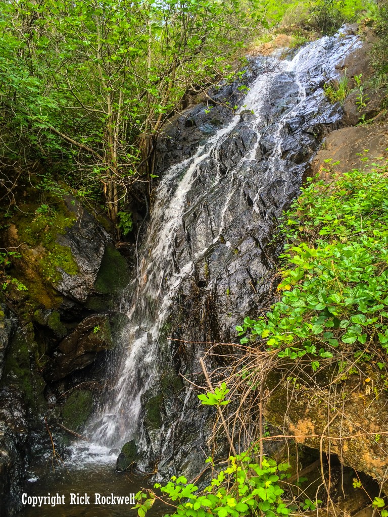
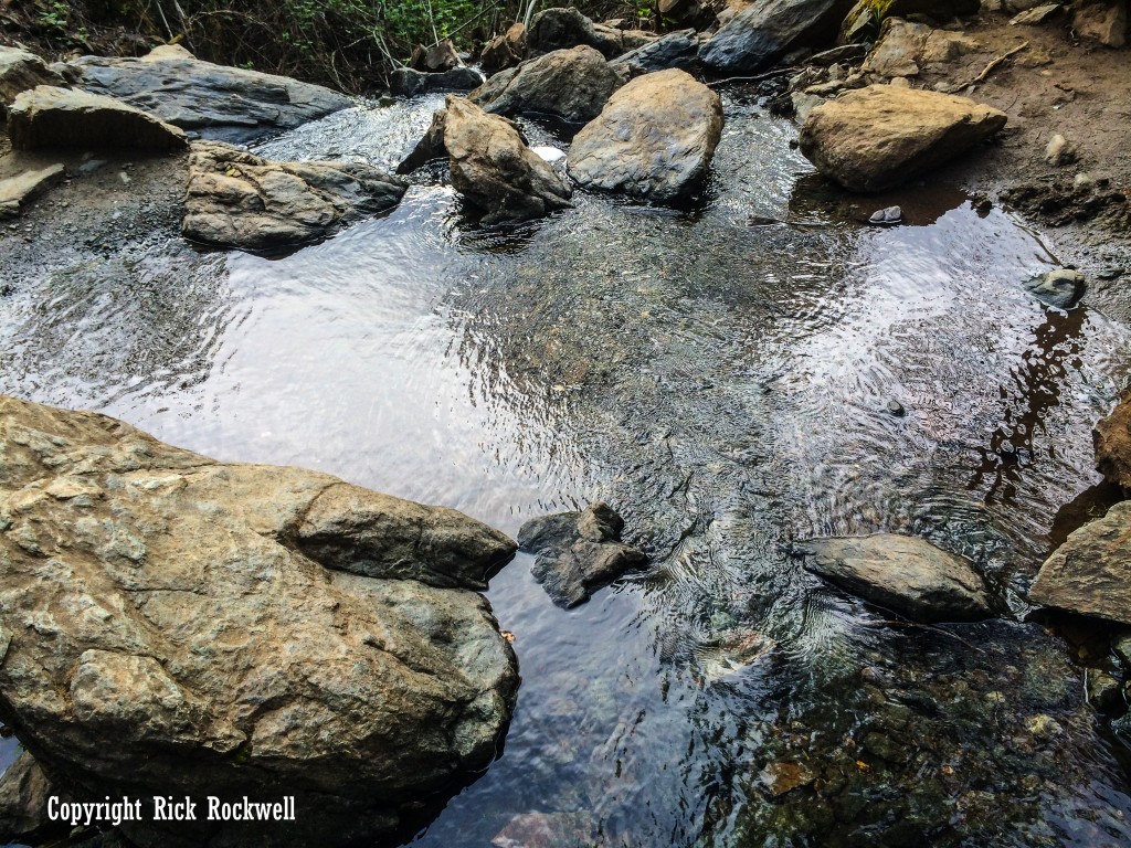
- Use caution near the waterfall and river.
- Check Auburn SRA alerts before visiting.
The hike is easy by Auburn standards, but the American River canyon should still be treated with respect. Summer heat, cold river water, and loose or uneven footing can turn a short outing into a rough one if you come unprepared.
The Railroad History Behind the Trail
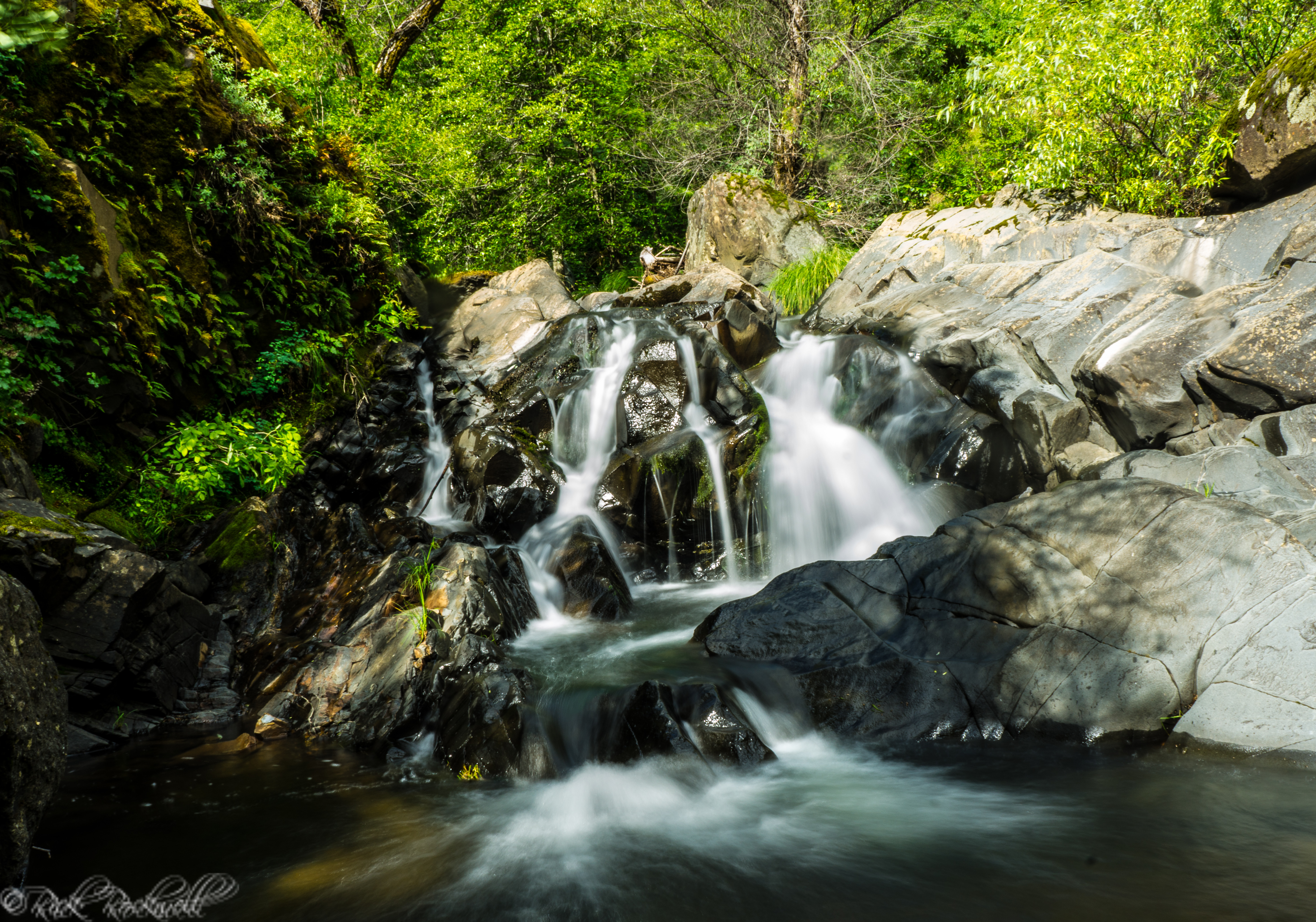
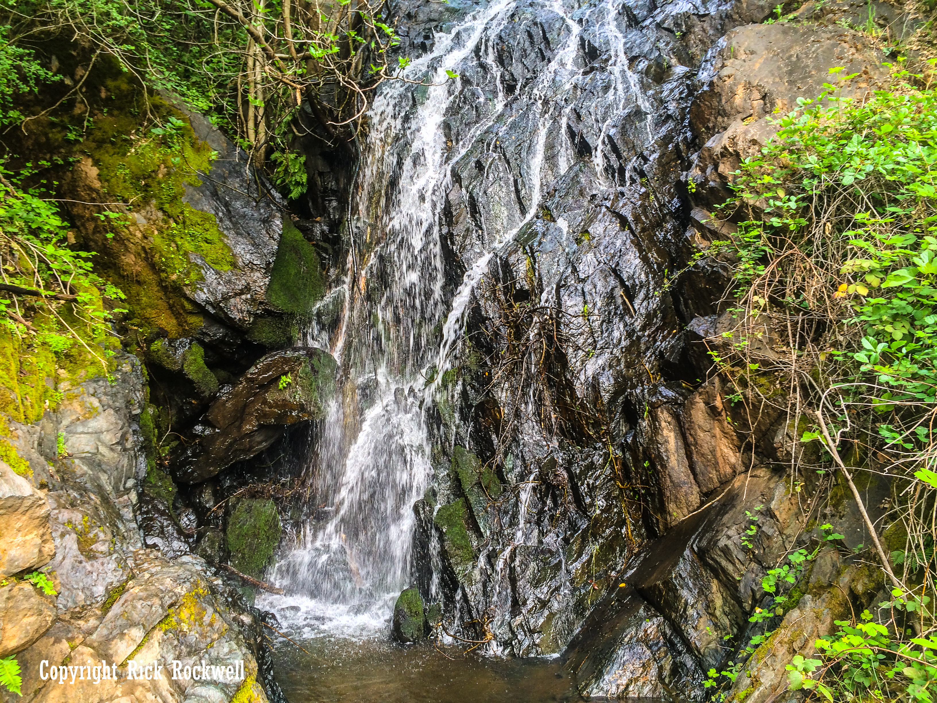
Black Hole of Calcutta Falls feels like an easy canyon walk today, but the route follows part of a much older industrial corridor. The Mountain Quarries Railroad once connected limestone quarry operations in the American River canyon with Auburn and the Southern Pacific Railroad, and that history still shapes the hike.
The gentle grade is one clue. This route was built for trains before it became a recreation trail, which helps explain why the walk to the falls feels easier than many steeper Auburn canyon hikes nearby.
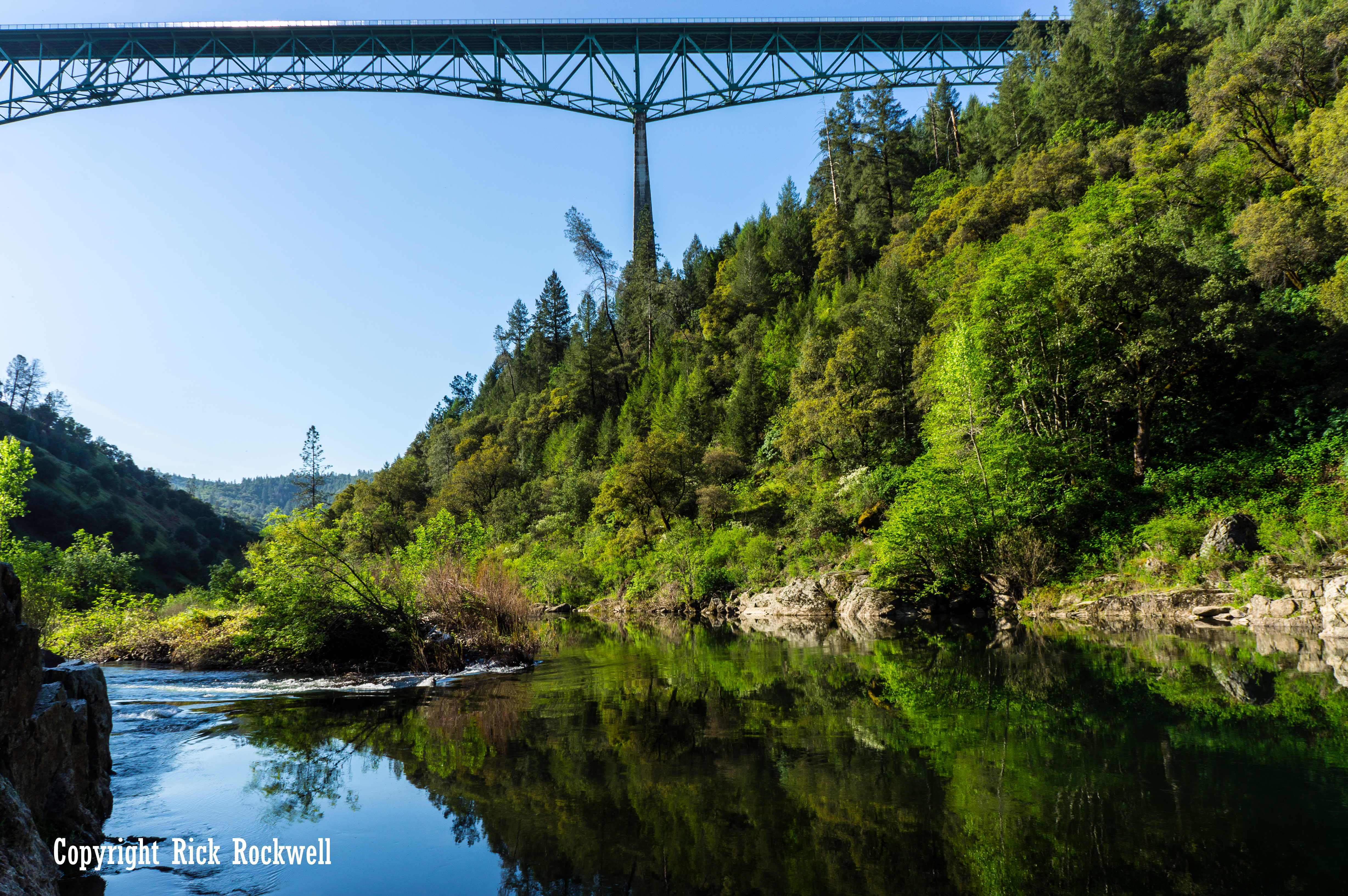
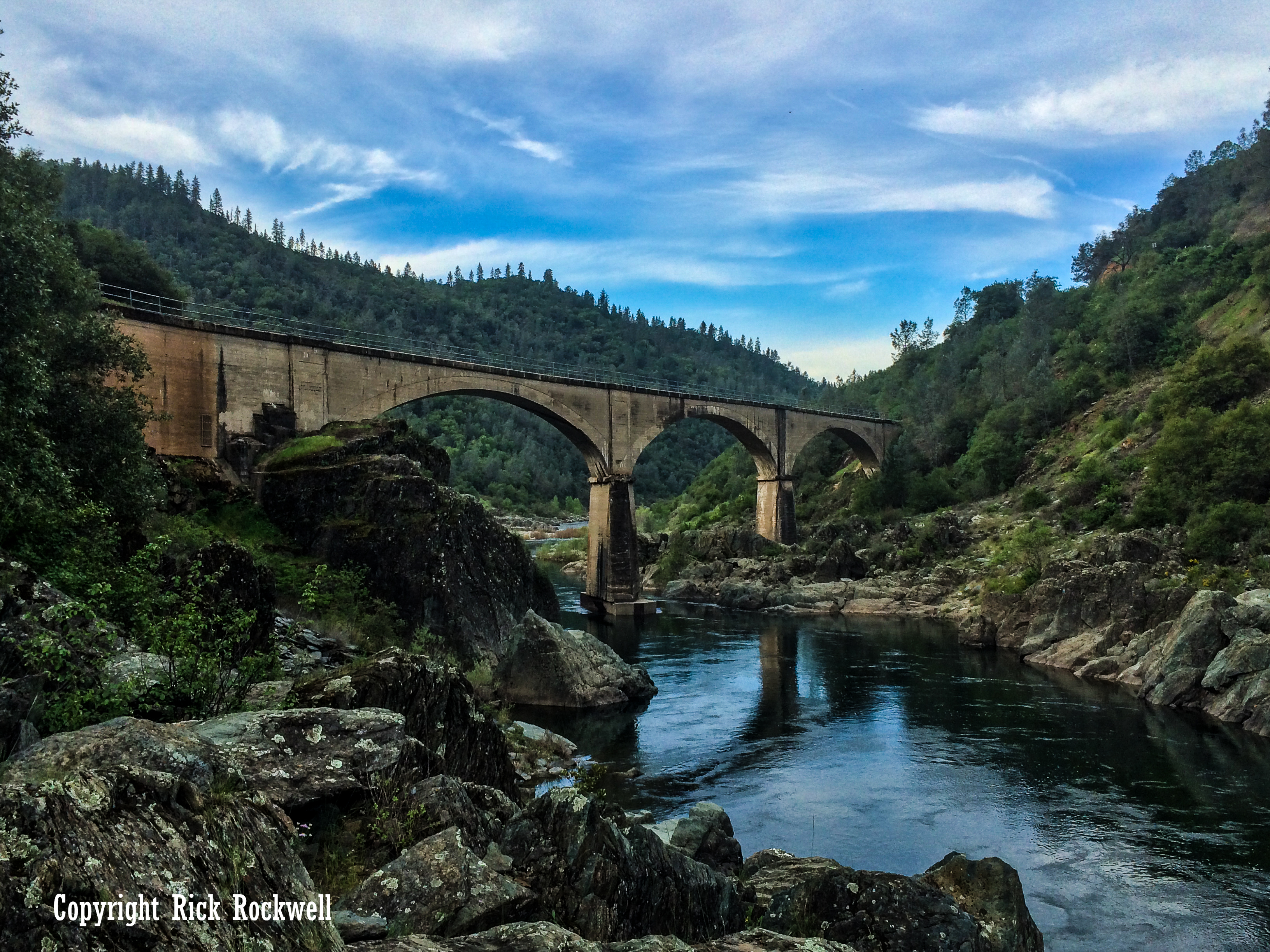
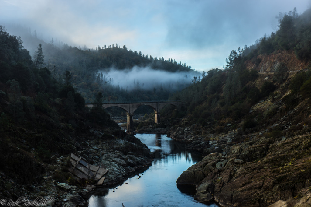
No Hands Bridge, officially known as the Mountain Quarries Railroad Bridge, is the most visible reminder of that past. Built in 1912 for the railroad, it now serves hikers, runners, horseback riders, and cyclists on the Western States Trail.
For the full story behind the bridge itself, including its construction, railroad use, flood survival, and famous nickname, read my full guide to No Hands Bridge.

No Hands Bridge in the Winter
Nearby Places to Visit
Black Hole of Calcutta Falls is easy to pair with other Auburn-area stops. If you want to turn the hike into a half-day or full-day outing, these nearby places fit well.
No Hands Bridge
No Hands Bridge is part of the hike itself, but it is worth treating as its own historic stop because of its railroad past, concrete arch design, and connection to the Western States Trail.
Lake Clementine Trail
The Lake Clementine Trail is one of Auburn’s best hikes, leading to the dramatic spillway at North Fork Dam and offering a longer canyon experience than Black Hole of Calcutta Falls.
Quarry Trail
The Quarry Trail follows the Middle Fork American River and gives visitors another easy-to-moderate Auburn SRA route with river scenery, mining history, and access to the deeper canyon corridor.
Clark’s Hole
Clark’s Hole is a popular American River swimming area near Auburn, though river conditions can be dangerous and should always be checked before entering the water.
Foresthill Bridge
The Foresthill Bridge is one of Placer County’s most recognizable landmarks and gives visitors a dramatic look across the American River canyon from high above the water.
Old Town Auburn
Old Town Auburn is a good post-hike stop for food, coffee, historic buildings, and a historic atmosphere.
Hidden Falls Regional Park
Hidden Falls Regional Park offers a more developed waterfall hiking experience near Auburn, with maintained trails, bridges, viewing areas, and a reservation system for parking.
Is Black Hole of Calcutta Falls Worth Visiting?
Yes, especially if you want a short Auburn hike with a little more character than the mileage suggests. Its appeal comes from the full package: the strange name, the easy trail, No Hands Bridge, American River canyon views, old railroad history, and a seasonal cascade emerging from a dark little pocket of rock.
I’ve been on this trail through all four seasons, but I prefer the winter and spring when the flow is greater and the gloomy, overcast days add a certain mystique to this area. However, that does require more careful hiking and caution for weather changes, water changes, and loose footing.
Ultimately, the Black Hole of Calcutta Falls is a great addition to any Auburn State Recreation Area visit, especially pairing it with other outdoor activities near the confluence like picnicking, rafting, hiking, and the Lake Clementine Trail.
Black Hole of Calcutta Falls FAQ
Where is Black Hole of Calcutta Falls?
Black Hole of Calcutta Falls is in Auburn State Recreation Area near Auburn, California. The hike starts near the American River Confluence and follows part of the Western States Trail / Canyon Creek Trail route.
How long is the Black Hole of Calcutta Falls hike?
The hike is about 2.2 miles round trip with an elevation gain of just under 260 feet.
How tall is Black Hole of Calcutta Falls?
Black Hole of Calcutta Falls is generally described as roughly 40 feet tall.
Is Black Hole of Calcutta Falls an easy hike?
Yes. It is generally considered an easy hike because the route is short and follows a relatively gentle old railroad grade.
When is the best time to see Black Hole of Calcutta Falls?
Late winter and spring are usually the best times to see the waterfall flowing. After storms or during spring runoff, the falls are much more impressive than they are in dry summer or fall conditions.
Do you cross No Hands Bridge on this hike?
Yes. The route to Black Hole of Calcutta Falls crosses No Hands Bridge, officially known as the Mountain Quarries Railroad Bridge. The bridge was built in 1912 and is now one of the signature landmarks in Auburn State Recreation Area.
Are dogs allowed on the Black Hole of Calcutta Falls trail?
Yes. Dogs are allowed, but they must be leashed.
Is there a parking fee?
There may be, depending on where you park. Roadside parking may be available near the trailhead, but the latter will require a $10 fee.
Can you swim at Black Hole of Calcutta Falls?
The pool at the falls is small and seasonal, so this is better treated as a scenic waterfall stop than a swimming destination.
Sources
California State Parks — Auburn State Recreation Area
https://www.parks.ca.gov/?page_id=502
California State Parks — Auburn SRA Trails
https://www.parks.ca.gov/?page_id=1345
California Office of Historic Preservation — Mountain Quarries Railroad Bridge
https://ohp.parks.ca.gov/ListedResources/Detail/1051
National Park Service / NRHP Documentation — Mountain Quarries Bridge
https://npgallery.nps.gov/NRHP/GetAsset/NRHP/04000014_text
AllTrails — Western States Trail to Calcutta Falls
https://www.alltrails.com/trail/us/california/western-states-trail-to-calcutta-falls
World Waterfall Database — Black Hole of Calcutta Falls
https://www.worldwaterfalldatabase.com/waterfall/Black-Hole-of-Calcutta-Falls-6727
WaterfallsWest — Black Hole of Calcutta Falls
https://www.waterfallswest.com/waterfall.php?id=black-hole-of-calcutta-falls-303
Inspired Imperfection — Canyon Creek Trail to Black Hole of Calcutta Falls
https://inspiredimperfection.com/adventures/canyon-creek-trail-black-hole-of-calcutta-falls/