Native American rock art refers to the images created by Indigenous peoples on rock surfaces. However, I would argue that “art” isn’t an accurate term for these fascinating drawings, paintings (pictographs), carvings (petroglyphs) and ground designs (geoglyphs).
Instead, I would categorize these rock arts as “timeless communications” that give us a small glimpse into the tribal cultures that made them.
With that in mind, California is home to many incredible rock art sites. The following is a list (in alphabetical order) of notable Native American Petroglyphs, Pictographs, and Geoglyphs found in California.
Types of California Native American Rock Art
The following is a quick overview of the different types of Native American rock art:
Geoglyphs: are large drawings made on the ground. They’re typically created by scraping or chiseling away at the hard, exterior surface to unveil a lighter colored surface beneath.
Petroglyphs: created by using tools made of stone to chisel, peck and scrape at the hard rock surfaces. Cupules are often classified as petroglyphs as they’re small man-made hollows into rock surfaces. However, they can serve a variety of purposes in addition to communication.
Pictographs: this form of rock art is typically found on cave walls where various natural items are used to create different colors for painting and drawing. They’re also rarer than the other types of rock art due to the increased deterioration from environmental elements.
Aiken’s Wash
Location: Mojave National Preserve, San Bernadino County
Access: Short hike from the Aiken’s Wash Trailhead
Protected: Added to NRHP in May 1982
Type: Petroglyphs
Associated Tribes: Mojave
Highlights: A dense concentration of petroglyphs etched into large desert boulders and canyon walls. These petroglyphic designs feature abstract shapes, human-like figures, and animal themes. It’s believed that many of these carvings reflect hunting rituals, ceremonial traditions, and spiritual beliefs of the Mojave people. The two most prominent groupings are at Milky Way Caves and Aiken’s Arch.
Barker Dam
Location: Joshua Tree National Park
Access: Short hike from Barker Dam Trailhead
Protected: Added to NRHP in October 1975
Type: Petroglyphs
Associated Tribes: Serrano, Cahuilla
Highlights: This desert rock art illustrates aspects of daily life for the Serrano and Cahuilla tribes. The carvings of animals, symbols and other figures further demonstrate the spiritual beliefs and ceremonial traditions of these tribes. Many of the petroglyphs are located near the dam and water sources, suggesting a powerful connection between the tribes and life-sustaining resources.
Black Mountain Rock Art District
Location: San Bernardino Mountains
Access: Short hike from Black Mountain Trailhead
Protected: Added to NRHP in September 2000
Type: Petroglyphs
Associated Tribes: Serrano
Highlights: The Black Mountain Rock Art District features a remarkable number of petroglyphs from the Serrano tribe. These carvings showcase humans, animals and other geometric shapes. The location of these petroglyphs, along with their designs, help illuminate the cultural and ritual life of the Serrano people.
Blythe Intaglios
Location: Near Blythe, Riverside County
Access: Best viewed from the air
Protected: Added to NRHP in August 1975
Type: Geoglyphs
Associated Tribes: Mojave, Quechan
Highlights: The Blythe Intaglios are a collection of large ground drawings that are best appreciated from the air due to their size. In fact, some geoglyphs measure over 100 feet long. The magnitude of these designs suggests a sophisticated planning and craftsmanship by the Mojhave and Quechan tribes. It’s assumed that these geoglyphs are linked to ceremonial rituals or astronomical occurrences.
Burro Flats Painted Cave
Location: Santa Susana Mountains
Access: Short hike from Burro Flats Trailhead
Protected: Added to NRHP in May 1976
Type: Pictographs
Associated Tribes: Chumash
Highlights: These ancient caves are associated with the Chumash tribe and the pictographs, which feature red, black and white colors of abstract symbols, are believed to represent ceremonial and spiritual practices. In fact, many of these symbols also blend into the tribe’s cosmology.
Chalfant Petroglyph Site
Location: Mono County
Access: Short hike from Chalfant Road
Protected: Added to NRHP in November 2000
Type: Petroglyphs
Associated Tribes: Shoshone
Highlights: Chalfant’s volcanic land features a compact array of Shoshone petroglyphs, which include human and animal shapes, along with spirals and other abstract symbols. The Shoshone language can be seen in the carvings along with the cultural expression from a tribe that dwelled in such challenging landscapes.
Chumash Painted Cave State Historic Park
Location: Near Santa Barbara
Access: Short hike; park hours vary
Protected: Added to NRHP in 1972, Became a State Park in 1976
Type: Pictographs
Associated Tribes: Chumash
Highlights: Similar to the Burro Flats Painted Cave, this small sandstone cave is another wonderful example of Chumash pictographs. However, instead of black, it boasts of green pigments. The figures and symbols are similar in concept, and are believed to have the same purpose. The cave has been well preserved and visitors can really enjoy this artistic expression of spirituality, community and cosmology.
Corn Springs
Location: Chuckwalla Mountains, Riverside County
Access: Graded dirt road; high-clearance vehicles recommended
Protected: Added to NRHP in October 1998
Type: Petroglyphs
Highlights: Large boulders covered in petroglyphs can be seen at Corn Springs in the Chuckwalla Mountains. These images demonstrate abstract symbols along with human and animal shapes. It’s believed that this site served as a location for spiritual rituals and ceremonial traditions.
Coso Rock Art District
Location: Mojave Desert, Coso Range
Access: Located within Naval Air Weapons Station China Lake; prior approval required
Protected: Added to NRHP in October 1999
Type: Petroglyphs
Associated Tribes: Coso people
Highlights: The Coso Rock Art District is one of the largest and most complex rock art sites in all of North America. With over 100,000 petroglyphs, this concentration of carvings presents a vast number of symbols and shapes that map a wonderful insight into the Coso people. The district is located on private land, so you can’t freely view these petroglyphs without permission from the US Navy.
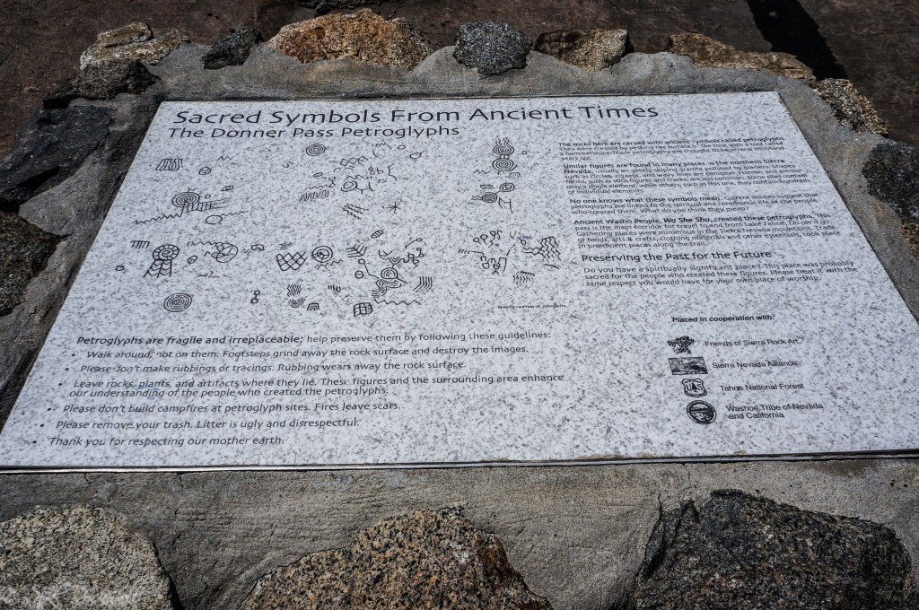
Donner Summit Petroglyphs
Location: Donner Pass, Nevada County
Access: Short hikes from trailheads near Old Highway 40 and Donner Pass Road
Type: Petroglyphs
Associated Tribes: Martis, possible ancestors to the Washoe
Highlights: The Donner Summit Petroglyphs are carved into granite slabs near the crest of the Sierra Nevada, the abandoned train tunnels, and China Wall. They’re easily accessible and estimated to be two to four thousand years old. Some of the symbols and shapes are believed to represent spiritual beliefs and season cycles. The location leads some scholars to think that these carvings were also maps or navigational details.
Fish Slough Petroglyphs
Location: Near Bishop, Mono County
Access: Short hike from Fish Slough Trailhead
Type: Petroglyphs
Associated Tribes: Paiute
Highlights: Located on volcanic formations, Fish Slough contains petroglyphs that are believed to represent spiritual customs, ceremonial practices, and ancient Paiute cosmology. Some scholars believe that these animal, human and other geometric shapes can also be a record of tribal events and history.
Hemet Maze Stone
Location: Riverside County
Access: Short hike from Hemet Maze Stone Trailhead
Protected: Added to CHL in 1956
Type: Petroglyph
Associated Tribes: Cahuilla
Highlights: A large slab of sandstone features petroglyphs that have a maze-like design. Scholars believe that these carvings are at least 500 years old and represent Cahuilla spiritual, ceremonial and cosmological beliefs. Others believe that it could be a map of some kind.
Lava Beds National Monument
Location: Near Tulelake, Siskiyou County
Access: Designated trails; some areas require short hikes
Protected: Became a Monument in 1925, Added to NRHP in 1991
Type: Petroglyphs and pictographs
Associated Tribes: Modoc
Highlights: This National Monument has a number of petroglyphs and pictographs throughout its borders. Petroglyph Point is a popular destination for rock art at this Monument, due to the large number of patterns and symbols found on the side of giant rock walls. Additionally, there are carvings and drawings found throughout caves and exposed lava rocks. It’s believed that these rock arts are connected to ancient Modoc traditions and rituals.
Meadow Lake Petroglyphs
Location: Nevada County
Protected: Added to NRHP in May 1971
Access: Short hike from Meadow Lake Campground
Type: Petroglyphs
Associated Tribes: Martis
Highlights: Meadow Lake features numerous petroglyphs etched into volcanic rocks. Animals, spirals and other shapes are prevalent in these carvings. It’s believed that they have spiritual and ceremonial importance to the Martis people just like at Donner Pass. Some scholars think that this collection of rock art could also be ritual markers or detailing of tribal events.
Painted Rock
Location: Carrizo Plain National Monument, San Luis Obispo County
Access: Short hike from Painted Rock Trailhead
Protected: Added as National Monument in January 2001
Type: Pictographs
Associated Tribes: Chumash, Salinan, Yokuts
Highlights: Painted Rock contains red, white, and black pictographs depicting humans, animals, and abstract forms. Scholars interpret the designs as ceremonial or symbolic, representing Chumash or other tribal cosmology, ancestral spirits, and seasonal cycles. The site provides important context for understanding the cultural and religious practices of Chumash communities in the Central Coast region.
Ring Mountain
Location: Marin County
Access: Short hike from Ring Mountain Open Space Preserve
Protected: Added as a Preserve in 1980s
Type: Petroglyphs
Associated Tribes: Coast Miwok
Highlights: Ring Mountain is home to various petroglyphs found on sandstone outcrops. They’re connect to the Coast Miwok people and include various abstract shapes, human figures, and handprints. It’s believed that these carvings are tied to Miwok ceremonies and spiritual traditions.
Sky Rock and 13 Moons
Location: Volcanic Tablelands, Bishop
Access: Short hike from Chalk Bluff Road
Type: Petroglyphs
Associated Tribes: Paiute and Shoshone
Highlights: Sky Rock and 13 Moons feature intricate carvings of lunar cycles, various figures, and symbols. Their duality of spiritual and astronomical purposes makes these petroglyphs even more fascinating. It’s a blend of art and science that demonstrates a high degree of sophistication for the Paiute and Shoshone tribes.
Tahquitz Canyon
Location: Palm Springs, Riverside County
Access: Guided tours; entry fee applies
Type: Petroglyphs
Associated Tribes: Agua Caliente Band of Cahuilla Indians
Highlights: Tahquitz Canyon contains petroglyphs that depict symbols, animals, and other figures that lead scholars to believe they’re meant to detail Cahuilla mythology, ancient traditions, ceremonial practices, and possibly even season cycles. What makes these carvings even more unique is the fact that they are located right near a 60-foot waterfall. Clearly giving this location even more spiritual and ceremonial significance.
Yellow Jacket Petroglyphs
Location: Eastern Sierra Nevada, Mono County
Access: Short hike from Yellow Jacket Mine Road
Protected: Added to NRHP in April 2000
Type: Petroglyphs
Associated Tribes: Shoshone
Highlights: Yellow Jacket Petroglyphs consist of volcanic-rock carvings that depict animal, human, and other abstract shapes. There are over 200 petroglyphs dating back thousands of years. They are believed to represent the ancient Shoshone language, ancestral teachings, and spiritual beliefs. Some of these carvings even point to the possibility of hunting rituals.
Sources:
Mojave Desert Archives. (n.d.). Aiken Wash: Aiken Cinder Cone & Lava Flow.
National Park Service. (n.d.). Barker Dam – Joshua Tree National Park.
Donner Summit Historical Society. (n.d.). Petroglyphs.
The Historical Marker Database. (2015). Donner Summit Canyon History Marker. Retrieved [Date], from HMDB website. HMDB
California Office of Historic Preservation. (n.d.). Black Canyon—Inscription Canyon—Black Mountain Rock Art District (N2101)
Bureau of Land Management. (n.d.). Blythe Intaglios.Wikipedia. (2025, [most recent update]). Coso Rock Art District.
California Register of Historical Resources (OHP). (n.d.). Burro Flats Painted Cave (Primary #19-000432).
Bureau of Land Management. (n.d.). Fish Slough Petroglyphs (Bishop Field Office)—directions & guidance.
California State Parks. (n.d.). Chumash Painted Cave State Historic Park.
Bureau of Land Management. (n.d.). Corn Springs Campground (with petroglyphs).
National Park Service. (n.d.). Coso Rock Art District (National Historic Landmark).
Bureau of Land Management. (n.d.). Fish Slough Petroglyphs.
Wikipedia. (2025, Jul.). Hemet Maze Stone.
National Park Service. (n.d.). Rock Art at Lava Beds (incl. Petroglyph Point Unit).
Wikipedia. (2023). Meadow Lake Petroglyphs.
Bureau of Land Management. (n.d.). Painted Rock (Carrizo Plain National Monument).
Marin County Parks. (n.d.). Ring Mountain Open Space Preserve.
Agua Caliente Tribal websites. (n.d.). Tahquitz Canyon.
Wikipedia. (2025, Aug.). Yellow Jacket Petroglyphs.