California Native American sacred sites are not just historic places on a map. They are living cultural places tied to creation stories, ceremonies, burial grounds, villages, trails, mountains, springs, lakes, caves, rock art, and the ongoing identity of California’s Indigenous communities.
Some Native American sacred sites in California are public parks or monuments where visitors can learn, hike, or view protected cultural resources from a distance. Others are sensitive, private, ceremonial, disputed, or only accessible through guided programs. That distinction matters. These places should not be treated like ordinary sightseeing stops.
This guide introduces some of the most important and publicly known sacred Native American sites in California, including Sáttítla, Mount Shasta, Chumash Painted Cave, Panhe, Sogorea Te’, Puvungna, Indian Canyon, Tomo-Kahni, Chaw’se, Coso, Tolay Lake, and Mount Konocti. It also explains what makes these places sacred, which sites have public access, and how visitors can approach them with more respect.
To better understand these places, it helps to start with the larger story of California Native Americans and the many tribes, regions, histories, and cultural connections that shape the state.
What Are Native American Sacred Sites?
Native American sacred sites can include many different kinds of places. A sacred site might be a mountain tied to creation stories, a spring used for healing, a village site, a burial ground, a ceremonial gathering place, a cave with rock paintings, an island, a lake, a petroglyph district, or a broader homeland where stories, songs, foodways, and traditions are rooted.
In California, these places are connected to many tribal nations and Indigenous communities. Some are still used for ceremonies, prayer, cultural education, and gatherings. Others are protected because of their archaeological, historical, or spiritual significance.
A sacred site does not have to look dramatic to be important. Some places are obvious landmarks, like Mount Shasta or Mount Konocti. Others may look like open fields, lakeshores, ridges, rock shelters, or quiet corners inside modern cities and college campuses. What makes them sacred is not how they appear to outsiders, but their connection to the people, ancestors, traditions, and living communities tied to that place.
That is why public access should never be confused with permission to treat a sacred place casually. If a site is open to visitors, stay in public areas, follow all rules, and remember that these places often carry meanings far deeper than what can be explained on an interpretive sign.
California’s map still carries many Indigenous names and names connected to Native leaders. That history shows up in towns, counties, lakes, mountains, rivers, and landmarks, which is why this guide to Native American place names in California is a useful companion to this article.
Before Visiting Native American Sacred Sites in California
Before visiting any Native American sacred site in California, remember that many of these places are active cultural spaces, not abandoned ruins or casual attractions.
Before You Visit | Why It Matters |
Stay in public areas or on designated trails | Protects cultural resources and avoids trespass |
Do not touch rock art, artifacts, mortars, burial areas, or cultural items | These are protected and culturally significant |
Do not take rocks, plants, objects, or anything from the land | Removing items can damage a sacred landscape |
Check whether photography is allowed | Some places restrict or discourage photography |
Leave drones at home unless explicitly allowed | Drones can disturb ceremonies, wildlife, and other visitors |
Respect ceremonies and gatherings | These are not performances or public entertainment |
Keep children and pets under control | Many sites are fragile and culturally sensitive |
Do not post precise locations of sensitive or hidden sites | Publicity can lead to vandalism or disturbance |
Pack out all trash | Leaving garbage behind is disrespectful and harmful |
Check current access rules before going | Legal status, tours, closures, and restrictions can change |
California has more than 100 federally recognized tribes, along with many other Indigenous communities with deep ties to the land. Some sacred places are well known and publicly interpreted. Others remain intentionally quiet to protect them from vandalism, looting, development, or casual misuse.
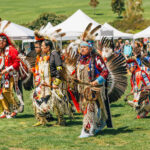
If your goal is to experience Native culture in a public community setting, California pow wows are usually a better fit than seeking out sensitive sacred places. Many pow wows welcome respectful visitors and offer a way to learn through dance, music, food, art, and community gathering.
Sacred Native American Sites in California
The following sacred Native American sites are some of the most notable and publicly known examples in California. This is not a complete list. Many sacred places are intentionally not publicized, and some should not be visited without direct permission or official guidance.
Sáttítla / Medicine Lake Highlands
Region/location: Northeastern California, around the Medicine Lake Highlands and Mount Hoffman area
Associated tribe/community: Pit River Tribe, Modoc Nation, and neighboring peoples
Type of site: Sacred volcanic highlands, traditional-use area, healing place, and protected cultural landscape
Public access: Public lands, but check current monument status, land-manager rules, and seasonal conditions before visiting
Respect note: Treat the area as a place of ongoing cultural meaning, not just a scenic recreation area
Sáttítla, also known as the Medicine Lake Highlands, is one of the most culturally significant sacred landscapes in far Northern California. The region is tied to the Pit River Tribe and neighboring peoples, who have long described the highlands as a place of healing, renewal, ceremony, and connection between the physical and spiritual worlds.
The landscape includes volcanic features, forests, highlands, water sources, and traditional-use areas. The effort to protect Sáttítla also followed decades of tribal opposition to geothermal development in the Medicine Lake Highlands, where energy leases and drilling proposals raised concerns about damage to a sacred volcanic landscape.
In January 2025, Sáttítla was designated as a national monument, giving the area heightened federal recognition and protection. Because monument management, access guidance, and land-use details can change, visitors should check current federal and land-manager information before relying on protection or access details.
This is not simply a natural wonder. For connected tribes, Sáttítla remains part of a living relationship between land, water, ceremony, and cultural survival. The Protect Sáttítla campaign provides more context on the cultural meaning of the Medicine Lake Highlands and the long effort to protect the area.
Sáttítla also fits into the larger story of Native American history in California national parks and monuments, where public lands overlap with Indigenous history, traditional homelands, and protected cultural landscapes. Farther north, Captain Jack’s Stronghold at Lava Beds National Monument adds more Modoc history to that same broader region.
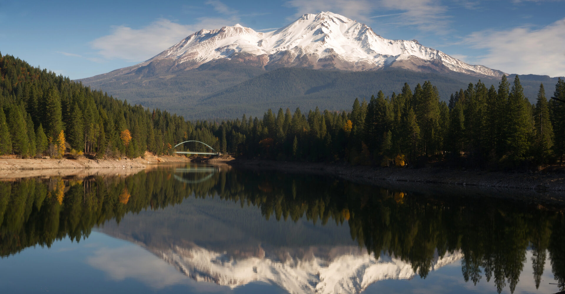
Mount Shasta
Region/location: Far Northern California, near Mount Shasta, CA 96067
Associated tribe/community: Karuk, Pit River, Shasta, Wintu, and other Native peoples
Type of site: Sacred mountain, creation-story landscape, ceremonial place, and living ancestor to some communities
Public access: Public mountain access, but visitors should respect ceremonial use, sensitive areas, and posted rules
Respect note: Do not treat the mountain’s sacred significance as a tourist novelty or personal spiritual playground
Mount Shasta is one of California’s most recognizable mountains, rising more than 14,000 feet above the far northern part of the state. For many visitors, it is a dramatic volcanic peak, a hiking destination, and a landmark seen from miles away.
For several Native communities, including the Karuk, Pit River, Shasta, Wintu, and others, Mount Shasta carries much deeper meaning. The mountain is tied to creation stories, ceremony, oral tradition, and ongoing cultural identity. Some tribal traditions describe the mountain not just as a place, but as a living presence.
Visitors can experience Mount Shasta through public roads, trails, viewpoints, and recreation areas, but respectful access matters. Stay on designated routes, follow all Forest Service and local rules, and be mindful that areas used for prayer or ceremony should never be disturbed.
Mount Shasta can inspire awe, but the more respectful lesson is humility. Long before it became a travel destination, this mountain was, and remains, sacred ground.
Other California lake and mountain landscapes carry similar layers of Native history, place names, and later settlement stories. In the Tahoe region, for example, Fallen Leaf Lake history shows how Native history and California landscape stories often overlap.
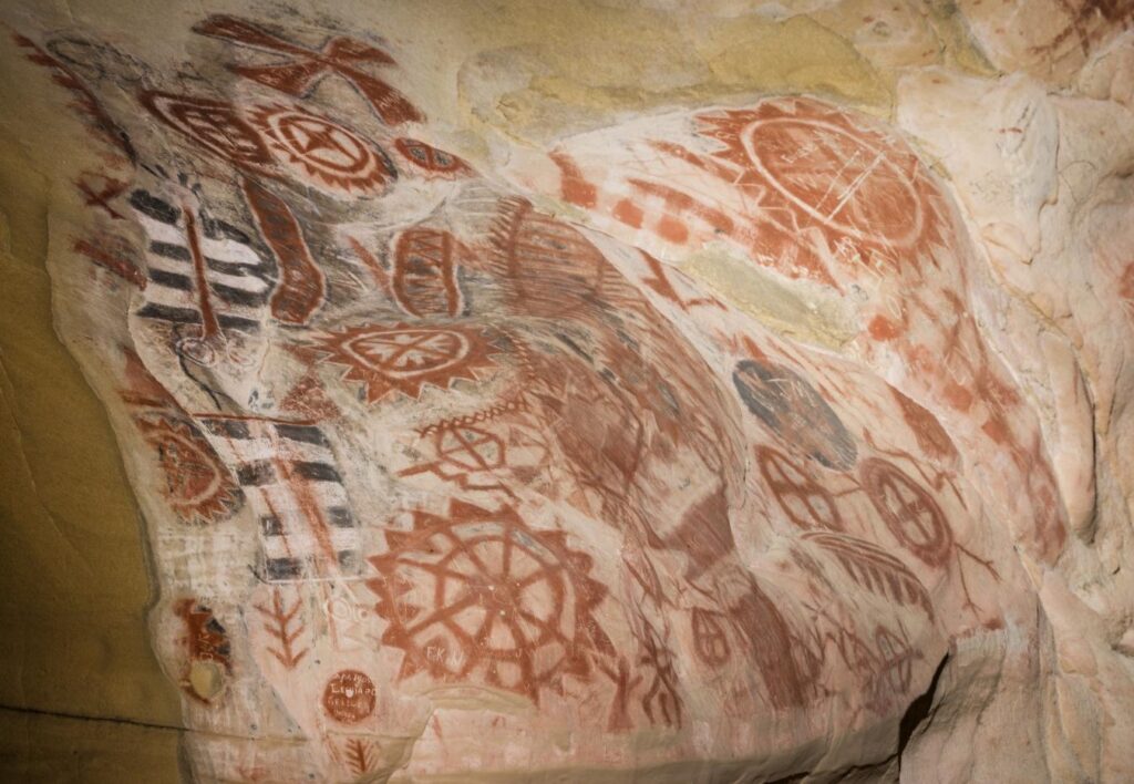
Chumash Painted Cave State Historic Park
Region/location: Santa Barbara County, along CA-154 above Santa Barbara
Associated tribe/community: Chumash
Type of site: Rock art cave and protected cultural site
Public access: Public state historic park; paintings are viewed from behind a protective gate
Respect note: Never touch, climb near, mark, or photograph rock art in ways that violate rules
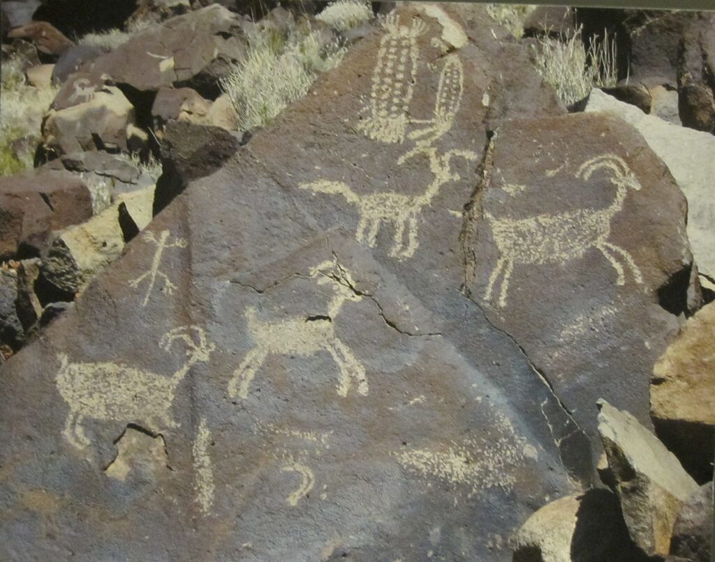
Located above Santa Barbara, Chumash Painted Cave State Historic Park protects one of California’s best-known examples of Chumash rock art. The small sandstone cave contains paintings that remain an important touchstone of Chumash culture and heritage.
The cave is protected because the paintings are fragile and culturally significant. Visitors can view the rock art from behind a gate, which helps prevent vandalism, touching, and environmental damage. Current visitor information is available through California State Parks.
The paintings are often discussed as expressions of spiritual belief, ceremony, and Chumash cosmology, though visitors should be cautious about overinterpreting them without tribal or scholarly context. Some sacred caves and rock art sites remain hidden or restricted to protect them from vandalism and misuse.
Chumash Painted Cave shows how public access and protection can work together. You can visit, learn, and appreciate the site, but only from a respectful distance.
California has several publicly known rock art sites, but all of them require care. This guide to California Native American petroglyphs and pictographs covers more places where visitors can learn about protected pictographs, petroglyphs, and geoglyphs without treating them like ordinary roadside attractions.
Panhe
Region/location: San Onofre State Beach / San Clemente area, near Beach Club Road
Associated tribe/community: Acjachemen / Juaneño people
Type of site: Ancient village, burial, ceremonial, and cultural site
Public access: Located within San Onofre State Beach; visitors should stay in public areas and respect sensitive cultural zones
Respect note: Remember that Panhe is not just an archaeological site. It remains sacred to Acjachemen people today
Panhe is an ancient Native American village and sacred site located within San Onofre State Beach. California State Parks describes Panhe as a large village and burial site of the Acjachemen people dating back more than 8,000 years. Many Acjachemen people trace their lineage to Panhe, and the site continues to hold ceremonial and cultural importance.
Panhe is also historically significant because it is associated with early contact between Spanish explorers, Catholic missionaries, and the Acjachemen people during the 1769 Portolá expedition. It has also been documented as the site of the first baptism in California’s colonial period.
In the 2000s, Panhe became the focus of one of California’s most visible sacred-site preservation battles. A proposed toll road near San Onofre raised concerns about impacts to the ancient village, burial areas, wetlands, public recreation, and nearby cultural resources. Tribal members, environmental groups, park advocates, surfers, and preservation supporters all became part of the fight to protect the area.
Today, Panhe remains an ancestral and ceremonial place. Visitors to San Onofre should avoid treating the area like an ordinary beach stop. Stay in designated public areas, follow California State Parks rules, and recognize that this is a place of ancestry, ceremony, and memory.
Sogorea Te’ / Glen Cove
Region/location: Vallejo, along the Carquinez Strait in the Glen Cove area
Associated tribe/community: Karkin Ohlone and Ohlone communities
Type of site: Ancient village, burial ground, ceremonial place, and preservation site
Public access: Sensitive area; follow current local access rules and tribal/land-trust guidance
Respect note: Avoid disturbing the landscape, posting sensitive location details, or treating burial grounds as recreation space
Sogorea Te’, also known as Glen Cove, is a 3,500-year-old Karkin Ohlone village and burial site located along the Carquinez Strait near Vallejo. Archaeological records and tribal advocacy have long identified this area as a deeply important cultural and sacred place.
The site became widely known through a preservation struggle over proposed development and park construction plans. In 2011, Native activists and supporters maintained a ceremonial presence at the site for more than 100 days, drawing wider attention to Ohlone efforts to protect burial grounds and sacred places in the Bay Area. The Sogorea Te’ Land Trust takes its name from this sacred place and the broader struggle to protect it from desecration.
Because Sogorea Te’ is tied to burial grounds and ceremonial significance, it should be approached with particular care. This is not a standard park-history stop. It is a place connected to ancestors, cultural survival, land return efforts, and the ongoing work of Indigenous stewardship.
If you visit the Glen Cove area, stay in public areas, avoid disturbing the ground, and follow the guidance of local Native-led organizations and posted rules.
The Bay Area’s Native history reaches well beyond one place. The story of Chief Marin adds Coast Miwok context to Marin County, Marin City, and the Marin Headlands, while Quintin’s story connects another Coast Miwok figure to the history behind San Quentin.
Puvungna
Region/location: Long Beach, on or near the California State University Long Beach campus
Associated tribe/community: Tongva, Acjachemen, and other Indigenous communities
Type of site: Ancient village, ceremonial site, creation-story landscape, and active sacred site
Public access: Located on/near the California State University Long Beach campus; access and preservation issues remain sensitive
Respect note: Do not treat the site as vacant campus land. It continues to hold ceremonial and cultural importance
Puvungna is an ancient village and sacred site associated with the Tongva, Acjachemen, and other Indigenous communities. It remains an active sacred place connected to ceremony, gathering, and creation stories.
Located within the modern urban setting of California State University Long Beach, Puvungna is a powerful example of how sacred Indigenous places can persist inside heavily developed areas. CSULB notes that the site is listed on the National Register of Historic Places and the California Native American Heritage Commission’s Sacred Lands Inventory, and that it continues to be significant to a number of tribal groups.
The site has also been at the center of preservation disputes. In 2019, construction soil and debris placed on Puvungna led to protests and legal action. A 2021 settlement restricted dumping, construction, equipment use, pesticides, and other activities that could interfere with cultural, ceremonial, or religious use of the land. Stewardship and implementation questions have continued, so visitors should be careful not to treat the area as ordinary campus open space.
Puvungna is often translated as “the place of the gathering” or “in the ball,” depending on the source. Its survival within a dense urban campus setting makes it one of California’s most important reminders that sacred sites are not always remote, scenic, or obviously marked.
Indian Canyon
Region/location: Near Hollister, along Indian Canyon Road in the Gabilan Range
Associated tribe/community: Indian Canyon Mutsun Band of Costanoan-Ohlone
Type of site: Private sacred land, ceremonial sanctuary, cultural education place, and intertribal gathering area
Public access: Private/sacred land; check directly with Indian Canyon sources and do not assume open access
Respect note: This is a living ceremonial place, not a public park or casual roadside attraction
Indian Canyon is a sacred Native American place near Hollister, stewarded by the Indian Canyon Mutsun Band of Costanoan-Ohlone. It is described by Indian Canyon sources as a sanctuary in the Gabilan mountain range south of Hollister.
Historically, Indian Canyon served as a refuge for Native people seeking safety from the violence and forced disruptions of the Mission period. Today, it remains a place where Indigenous communities can hold ceremonies, gatherings, cultural programs, and educational events on private sacred land.
Indian Canyon is especially meaningful because it provides space for ceremony and cultural revitalization in a region where many Native communities endured displacement, missionization, and loss of access to ancestral lands.
Visitors should not assume that Indian Canyon is open for casual visitation. Check directly with Indian Canyon before planning a visit, event, or educational request.
Tomo-Kahni State Historic Park
Region/location: Tehachapi / Kern County
Associated tribe/community: Kawaiisu
Type of site: Seasonal village, rock art site, cultural landscape, and state historic park
Public access: Guided tours only through California State Parks; reservation details and meeting information are provided through the official tour process
Respect note: Stay with the guide, do not touch rock art or artifacts, and follow all tour restrictions
Tomo-Kahni State Historic Park protects a sacred Kawaiisu settlement in the Tehachapi Mountains. The name is commonly translated as “winter home” or “winter village,” reflecting the site’s role as a seasonal home within a larger network of movement, trade, food gathering, and ceremony across the southern Sierra and desert regions.
The park contains sensitive rock art, cultural resources, and ancestral places. Because of that sensitivity, Tomo-Kahni is not open for casual wandering. Access is by guided tour only through California State Parks.
State Parks notes that tours require reservations and are limited. Visitors should use the official State Parks or ReserveCalifornia process for current tour dates, meeting instructions, fees, and requirements.
The guided-tour model helps protect Tomo-Kahni while still allowing visitors to learn from the landscape. It is one of the clearest examples in California of access being possible only because that access is carefully controlled.
Chaw’se / Indian Grinding Rock State Historic Park
Region/location: Amador County / Sierra Nevada foothills, near Pine Grove
Associated tribe/community: Miwok and other Sierra Nevada Native communities
Type of site: Bedrock mortar site, ceremonial roundhouse, museum, and cultural landscape
Public access: Public state historic park
Respect note: View cultural features respectfully and do not touch or climb on grinding rocks, petroglyphs, or ceremonial areas
Chaw’se, also known as Indian Grinding Rock State Historic Park, is one of California’s most important public places for learning about Sierra Native culture. “Chaw’se” means “grinding rock” in Miwok and refers to the bedrock mortars used to process acorns.
California State Parks describes the park as home to North America’s largest collection of bedrock mortars and California’s largest roundhouse still used by Native Americans. The site connects food, ceremony, song, gathering, and cultural continuity.
The grinding rock is not simply an artifact. It reflects a sophisticated acorn-processing system and a way of life deeply connected to oak woodlands, seasonal knowledge, and community practice. The park also includes the Chaw’se Regional Indian Museum, exhibits created with Native American partners, and a ceremonial roundhouse. Current visitor details are available through California State Parks and the Chaw’se Association.
Located east of Jackson in the Sierra Nevada foothills, Chaw’se is one of the easier sacred Native American sites in California to visit responsibly. It is also a place where visitors need to be especially mindful. Stay on paths and viewing areas, respect ceremonial spaces, and avoid treating cultural features like ordinary rocks.
Coso Hot Springs and Coso Rock Art District
Region/location: Inyo County / Coso Range, within Naval Air Weapons Station China Lake
Associated tribe/community: Indigenous peoples connected to the Coso Range and desert-side Sierra landscapes
Type of site: Petroglyph district, mineral springs, sacred landscape, and restricted military-area cultural resource
Public access: Controlled by Naval Air Weapons Station China Lake; public petroglyph tours are currently paused
Respect note: Do not attempt unauthorized access. Only visit if official tours resume and you are approved through the proper process
The Coso Range holds one of North America’s most significant concentrations of petroglyphs, along with mineral springs long associated with healing and ceremony. The rock art includes bighorn sheep, human-like figures, geometric designs, and other images connected to deep Indigenous history in the desert-side Sierra region.
The Coso Rock Art District is located within Naval Air Weapons Station China Lake, which means access is highly restricted. In the past, limited guided tours were offered through the Maturango Museum and Navy channels. However, the Maturango Museum currently states that China Lake is not allowing petroglyph tours at this time. If tours resume, they are expected to be posted through official channels.
This section should be treated as cultural and historical context, not a visitor recommendation. Do not try to access the area independently. Unauthorized access is illegal, unsafe, and disrespectful to the sacred landscape.
For a public Sierra Nevada rock art site with a separate visitor experience, the Donner Pass Petroglyphs show how even accessible rock art should be viewed carefully and never touched.
Tolay Lake
Region/location: Sonoma County / Petaluma area, at Tolay Lake Regional Park
Associated tribe/community: Federated Indians of Graton Rancheria, including Coast Miwok and Southern Pomo communities
Type of site: Lake, healing landscape, cultural park, and regional park under tribal co-stewardship
Public access: Public regional park with trails and current Sonoma County park rules
Respect note: Stay on designated trails and recognize that the park is also a cultural and ceremonial place, not just open space
Tolay Lake sits within a broad basin outside Petaluma and has long been connected to Native American habitation, ceremony, and healing. Although the lake is often dry at the surface, the surrounding landscape remains culturally important.
For the Federated Indians of Graton Rancheria, which includes Coast Miwok and Southern Pomo communities, Tolay Lake is a spiritual center and cultural landscape. Sonoma County Regional Parks and the Federated Indians of Graton Rancheria entered into a 20-year co-management agreement for the park, reflecting the importance of tribal stewardship in caring for its cultural, natural, and historical resources.
Today, Tolay Lake Regional Park offers public trails, open grasslands, ridges, and views of the surrounding region. But visitors should not see it only as a hiking area. The lake and surrounding hills are part of a much deeper story of ceremony, healing, land care, and Native presence in Sonoma County.
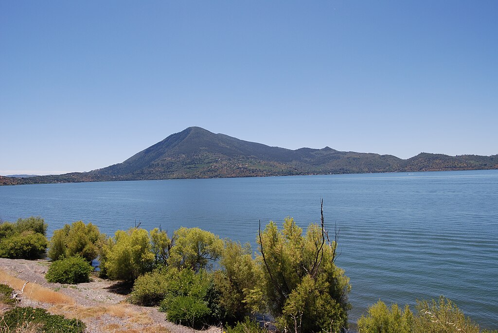
Mount Konocti and Rattlesnake Island
Region/location: Lake County / Clear Lake region
Associated tribe/community: Pomo peoples, including the Elem Indian Colony
Type of site: Sacred mountain, island, lake, ceremonial landscape, and ancestral homeland
Public access: Mixed public, private, and sensitive access depending on location
Respect note: Islands, shorelines, and mountain landscapes around Clear Lake are not empty recreation spaces; many remain culturally significant
Clear Lake is one of California’s oldest and most culturally important lake landscapes. For Pomo peoples, the lake, surrounding shorelines, islands, and mountains are tied to long histories of habitation, ceremony, and story.
Mount Konocti is one of the most prominent landmarks in the Clear Lake region and is widely connected to Pomo history and sacred geography. Rattlesnake Island has also been described in local histories and reporting as deeply important to the Elem Pomo, but access, ownership, and cultural sensitivity make it a place that should be discussed carefully.
Together, Mount Konocti, Clear Lake, and the surrounding shorelines point to a larger ancestral landscape rather than a single stop on a map. Visitors should approach the area with care. Some places around Clear Lake are public, some are private, and some are culturally sensitive. Do not assume that an island, shoreline, or hillside is open for exploration simply because it appears undeveloped.
Other Publicly Known Native American Sacred Places in California
The places above are the main sacred sites covered in this guide, but they are not the only publicly known Native American sacred places in California. Other landscapes, mountains, rock formations, waterfalls, and village sites also carry deep cultural meaning, including places such as Morro Rock / Lisamu’, Mount Diablo / Tuyshtak, Lassen Peak / Kohm Yah-Mah-Yee, McArthur-Burney Falls, and the West Berkeley Shellmound.
Some of these places are public parks or landmarks, while others are sensitive cultural or burial sites that should not be treated as casual attractions. Rather than expanding this guide into every known site, the focus here is on a select group where public access, cultural context, preservation history, and visitor behavior can be explained more carefully.
Quick Comparison of Native American Sacred Sites in California
After reading through the individual sites, this quick comparison can help you see which places are public parks, which require guided access, and which should be approached mainly as sensitive cultural landscapes rather than casual sightseeing stops.
Site | Region | Associated Community | Type of Site | Public Access |
Sáttítla / Medicine Lake Highlands | Northeastern California | Pit River Tribe, Modoc Nation, and neighboring peoples | Sacred volcanic highlands and cultural landscape | Public lands; check current monument status and land-manager rules |
Mount Shasta | Far Northern California | Karuk, Pit River, Shasta, Wintu, and others | Sacred mountain and creation-story landscape | Public mountain access, but respect ceremonial use |
Chumash Painted Cave | Santa Barbara County | Chumash | Rock art cave and cultural site | Public state historic park; view paintings from behind protection |
Panhe | San Onofre / San Clemente area | Acjachemen / Juaneño people | Ancient village, burial, ceremonial, and cultural site | Within San Onofre State Beach; respect sensitive areas |
Sogorea Te’ / Glen Cove | Vallejo | Karkin Ohlone / Ohlone communities | Village, burial, and ceremonial site | Sensitive site; follow current local and Native-led guidance |
Puvungna | Long Beach | Tongva, Acjachemen, and other Indigenous communities | Village and ceremonial site | On/near CSULB; active sacred site with preservation concerns |
Indian Canyon | Near Hollister | Indian Canyon Mutsun Band of Costanoan-Ohlone | Ceremonial sanctuary and cultural land | Private/sacred land; do not assume open access |
Tomo-Kahni | Tehachapi | Kawaiisu | Seasonal village, rock art, and cultural landscape | Guided tours only through California State Parks |
Chaw’se / Indian Grinding Rock | Amador County | Miwok and other Sierra Native communities | Bedrock mortars, roundhouse, museum, ceremonial landscape | Public state historic park |
Coso Rock Art District | Inyo County / China Lake | Indigenous peoples of the Coso Range | Petroglyph district and sacred landscape | Access controlled by Navy; tours currently paused |
Tolay Lake | Sonoma County | Federated Indians of Graton Rancheria, Coast Miwok, Southern Pomo | Lake, healing landscape, cultural park | Public regional park with tribal co-stewardship |
Mount Konocti & Rattlesnake Island | Lake County | Pomo peoples, including Elem Indian Colony | Sacred mountain, island, lake, and ceremonial landscape | Mixed public/private/sensitive access; check before visiting |
Why Respectful Access Matters
Native American sacred sites in California are part of a much larger story of Indigenous survival, land stewardship, cultural continuity, and ongoing protection. Many of these places endured missionization, colonization, development pressure, vandalism, looting, road projects, legal battles, university expansion, and public misunderstanding.
That is why this guide does not treat sacred sites as a simple bucket list. Some places can be visited through public parks, guided tours, or designated trails. Others should be understood from a distance, through tribal sources, museums, official pages, or cultural education programs.
California’s Native history also lives through people whose names remain attached to counties, towns, rivers, and regions. Stories of figures like Chief Marin, Chief Truckee, and Chief Solano show how Native leaders became connected to different parts of California history, even when those stories are complicated by colonization, translation, and later retellings.
Public memorials and monuments can add another layer to that discussion. This guide to California’s Native American statues looks at how Native people and leaders have been remembered in public spaces across the state.
Native American history is woven into California’s places, names, landscapes, and communities. You cannot fully understand the state without understanding the Indigenous histories that came first and continue today.
FAQ: Native American Sacred Sites in California
Can you visit Native American sacred sites in California?
Some Native American sacred sites in California are open to the public through state parks, regional parks, monuments, or guided tours. Others are private, restricted, ceremonial, or sensitive. Always check the official land manager, tribal source, or park page before visiting.
Are Native American sacred sites the same as archaeological sites?
Not always. Some sacred sites include archaeological features like rock art, village remains, mortars, or burial grounds. But sacred sites are not just “old sites.” Many are active cultural places connected to ceremony, identity, stories, and ongoing tribal stewardship.
Why are some sacred sites not publicly identified?
Some sacred sites are kept quiet to protect them from vandalism, looting, trespass, and disturbance. Publicizing precise locations can harm the very places people claim to appreciate.
Is it okay to photograph Native American sacred sites?
It depends on the site. Some public parks allow general photography, while some ceremonial, rock art, or culturally sensitive places may restrict or discourage it. Always check posted rules and avoid photographing ceremonies, people, or restricted areas without permission.
Can you touch rock art or grinding stones?
No. Never touch rock art, grinding stones, mortars, artifacts, burial areas, or cultural items. Oils from hands, pressure, climbing, and repeated contact can damage fragile cultural resources. It is also deeply disrespectful.
Which Native American sacred sites in California are easiest to visit?
Chaw’se / Indian Grinding Rock State Historic Park and Chumash Painted Cave State Historic Park are among the easier public sites to visit responsibly, though both still require respectful behavior and protection of cultural resources. Tomo-Kahni is accessible only through guided State Parks tours.
Are all sacred sites listed here tourist attractions?
No. This article includes some public parks and some sensitive cultural places. Several places should be approached as educational or historical context rather than casual travel stops.
Sources
Official, Tribal, and Land-Trust Sources
U.S. Forest Service – Sáttítla Highlands National Monument
https://www.fs.usda.gov/visit/national-monuments/sattitla-highlands-national-monument
Federal Register – Establishment of the Sáttítla Highlands National Monument
https://www.federalregister.gov/documents/2025/01/17/2025-01443/establishment-of-the-stttla-highlands-national-monument
Protect Sáttítla – Medicine Lake Highlands
https://www.protectsattitla.org/
California Native American Heritage Commission – Acjachemen Sacred Site Panhe Saved
https://nahc.ca.gov/2008/
California Native American Heritage Commission – Puvungna Notice of Investigation
https://nahc.ca.gov/2021/08/nahc-notice-of-investigation-into-csulbs-actions-regarding-puvungna/
Sogorea Te’ Land Trust – Our History
https://sogoreate-landtrust.org/history/
Indian Canyon / Costanoan Indian Research
https://www.costanoan.org/
Indian Canyon Life
Judicial Branch of California – California Tribal Communities
https://courts.ca.gov/programs-initiatives/tribalstate-programs/california-tribal-communities
Park, Museum, University, and Public-Land Sources
California State Parks – Chumash Painted Cave State Historic Park
https://www.parks.ca.gov/?page_id=602
California State Parks – San Onofre State Beach / Panhe
https://www.parks.ca.gov/?page_id=647
California State Parks – Tomo-Kahni State Historic Park
https://www.parks.ca.gov/tomokahni
California State Parks – Tomo-Kahni Tour Information
https://www.parks.ca.gov/?page_id=24580
California State Parks – Indian Grinding Rock State Historic Park
https://www.parks.ca.gov/?page_id=553
Chaw’se Association – Indian Grinding Rock State Historic Park
California State University Long Beach – Puvungna
https://www.csulb.edu/puvungna
California State University Long Beach – Puvungna Protections and Conservation
https://www.csulb.edu/puvungna/protections-conservation
Maturango Museum – Coso Petroglyphs
Santa Barbara Museum of Natural History – Cave Painting
https://www.sbnature.org/collections-research/anthropology/chumash-life/cave-painting
Sonoma County Regional Parks – Tolay Lake Regional Park
https://parks.sonomacounty.ca.gov/visit/find-a-park/tolay-lake-regional-park
Sonoma County Regional Parks – County and Federated Indians of Graton Rancheria Sign Co-Management Agreement
https://parks.sonomacounty.ca.gov/county-federated-indians-of-graton-rancheria-sign-co-management-agreement-of-tolay-lake-regional-park
Advisory Council on Historic Preservation – Mount Shasta
https://www.achp.gov/success-stories/mount-shasta
Advisory Council on Historic Preservation – Mount Shasta PDF
https://www.achp.gov/sites/default/files/2018-07/Mount%20Shasta.pdf
Lake County – History of Lake County California / Mount Konocti
Legal, Preservation, and Historical Context Sources
Stanford Law School – ELC’s Ninth Circuit Win Protects Pit River Tribe’s Sacred Medicine Lake Highlands
Stanford Law School – The Sacred Place That Is Sáttítla
SMW Law – Settlement Reached with CSU-Long Beach Over Puvungna Sacred Tribal Land
Friends of Puvungna – History
https://www.friendsofpuvungna.org/history
Lake County News – Rattlesnake Island, the Deep Home Place of the Elem Pomo
https://lakeconews.com/news/14582-tuleyome-tales-rattlesnake-island-the-deep-home-place-of-the-elem-pomo-
News and Archive Sources
Los Angeles Times – Tribes, geothermal development, and Medicine Lake Highlands
https://www.latimes.com/archives/la-xpm-2002-jul-17-me-medicine17-story.html
Los Angeles Times – Toll Road Fight and Panhe
https://www.latimes.com/archives/la-xpm-2007-aug-20-me-toll20-story.html
Los Angeles Times – Coastal Commission Rejects Toll Road
https://www.latimes.com/archives/la-xpm-2008-feb-07-me-tollroad7-story.html
Los Angeles Times – Panhe Editorial
https://www.latimes.com/opinion/editorials/la-ed-panhe27-2008dec27-story.html
East Bay Express – Protecting Ohlone Heritage
Long Beach Post – Dumping Dirt on Puvungna
https://lbpost.com/news/dumping-dirt-puvungna-native-american-csulb/
Long Beach Post – Tribal Leaders, CSULB Reach Settlement Over Puvungna
https://lbpost.com/news/puvungna-csulb-settlement/
Signal Tribune – Puvungna Preservation / CSULB Coverage
Northern California Public Media – Tolay Lake Co-Management Agreement
https://norcalpublicmedia.org/2022100881747/news-feed/groundbreaking-agreement-made-official-for-tribal-authority-at-holy-lake